
Finger millet is an annual herbaceous plant widely grown as a cereal crop in the arid and semiarid areas in Africa and Asia. It is a tetraploid and self-pollinating species probably evolved from its wild relative Eleusine africana.

Slash-and-burn agriculture is a farming method that involves the cutting and burning of plants in a forest or woodland to create a field called a swidden. The method begins by cutting down the trees and woody plants in an area. The downed vegetation, or "slash", is then left to dry, usually right before the rainiest part of the year. Then, the biomass is burned, resulting in a nutrient-rich layer of ash which makes the soil fertile, as well as temporarily eliminating weed and pest species. After about three to five years, the plot's productivity decreases due to depletion of nutrients along with weed and pest invasion, causing the farmers to abandon the field and move to a new area. The time it takes for a swidden to recover depends on the location and can be as little as five years to more than twenty years, after which the plot can be slashed and burned again, repeating the cycle. In Bangladesh and India, the practice is known as jhum or jhoom.

In agriculture, a terrace is a piece of sloped plane that has been cut into a series of successively receding flat surfaces or platforms, which resemble steps, for the purposes of more effective farming. This type of landscaping is therefore called terracing. Graduated terrace steps are commonly used to farm on hilly or mountainous terrain. Terraced fields decrease both erosion and surface runoff, and may be used to support growing crops that require irrigation, such as rice. The Rice Terraces of the Philippine Cordilleras have been designated as a UNESCO World Heritage Site because of the significance of this technique.

Ruvuma Region is one of Tanzania's 31 administrative regions. The region covers a land area of 63,669 km2 (24,583 sq mi), comparable in size to the nation state of Latvia. The region is also bordered to the north by the Morogoro Region, to the northeast by the Lindi Region, to the east by the Mtwara Region,the west by Lake Nyasa with Malawi and to the northwest by the Njombe Region. The regional capital is the municipality of Songea.

Ugali, also known as posho, nsima, papa, pap, sadza, isitshwala, akume, amawe, ewokple, akple, and other names, is a type of corn meal made from maize or corn flour in several African countries: Kenya, Uganda, Tanzania, Zimbabwe, Zambia, Lesotho, Eswatini, Angola, Mozambique, Namibia, DRC, Malawi, Botswana and South Africa, and in West Africa by the Ewes of Togo, Ghana, Benin, Nigeria and Cote D'Ivoire. It is cooked in boiling water or milk until it reaches a stiff or firm dough-like consistency. In 2017, the dish was added to the UNESCO Representative List of the Intangible Cultural Heritage of Humanity, one of a few foods in the list.

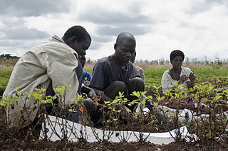
The Matengo are an ethnic and linguistic group based in Mbinga District, Ruvuma Region in southern Tanzania. In 1957, the population estimate was 57,000, while in 2010, the Matengo population was estimated to number 284,000. Their religious affiliation is to Christianity. Their Affinity Bloc is Sub-Saharan African. Their main language is Matengo, which is one of the Bantu languages.
The main economic products of Malawi are tobacco, tea, cotton, groundnuts, sugar and coffee. These have been among the main cash crops for the last century, but tobacco has become increasingly predominant in the last quarter-century, with a production in 2011 of 175,000 tonnes. Over the last century, tea and groundnuts have increased in relative importance while cotton has decreased. The main food crops are maize, cassava, sweet potatoes, sorghum, bananas, rice, and Irish potatoes and cattle, sheep and goats are raised. The main industries deal with agricultural processing of tobacco, tea and sugar and timber products. The industrial production growth rate is estimated at 10% (2009).

Agriculture employs the majority of Madagascar's population. Mainly involving smallholders, agriculture has seen different levels of state organisation, shifting from state control to a liberalized sector.

Chitemene, from the ciBemba word meaning “place where branches have been cut for a garden”, is a system of slash and burn agriculture practiced throughout northern Zambia. It involves coppicing or pollarding of standing trees in a primary or secondary growth Miombo woodland, stacking of the cut biomass, and eventual burning of the cut biomass in order to create a thicker layer of ash than would be possible with in situ burning. Crops such as maize, finger millet, sorghum, or cassava are then planted in the burned area.
Indigenous horticulture is practised in various ways across all inhabited continents. Indigenous refers to the native peoples of a given area and horticulture is the practice of small-scale intercropping.
The Matengo Highlands are located in the western part of the mountainous area of Mbinga District, Ruvuma Region in southern Tanzania. They are home to the Matengo people. Kindimba is the historical center of the highlands. It is located on highland's western side, approximately 15 km west of Mbinga. Its subvillages include Kindimba, Kitanda, Mkanya, Mutugu, Ndembo, Torongi, Walarzi. In 2006, the total Kindimba population was 2440. Other towns and villages include Litembo and Lipumba.
Lipumba is a village in Mbinga district in the Iringa Region of the Tanzanian Southern Highlands. It is located in the Matengo Highlands and is inhabited by the Matengo people. Lipumba is located to the northeast of the town of Mbinga and lies off the A19 road which connects it to Songea in the east.

Farming systems in India are strategically utilized, according to the locations where they are most suitable. The farming systems that significantly contribute to the agriculture of India are subsistence farming, organic farming, industrial farming. Regions throughout India differ in types of farming they use; some are based on horticulture, ley farming, agroforestry, and many more. Due to India's geographical location, certain parts experience different climates, thus affecting each region's agricultural productivity differently. India is very dependent on its monsoon cycle for large crop yields. India's agriculture has an extensive background which goes back to at least 9 thousand years. In India, in the alluvial plains of the Indus River in Pakistan, the old cities of Mohenjo-Daro and Harappa experienced an apparent establishment of an organized farming urban culture. That society, known as the Harappan or Indus civilization, flourished until shortly after 4000 BP; it was much more comprehensive than those of Egypt or Babylonia and appeared earlier than analogous societies in northern China. Currently, the country holds the second position in agricultural production in the world. In 2007, agriculture and other industries made up more than 16% of India's GDP. Despite the steady decline in agriculture's contribution to the country's GDP, agriculture is the biggest industry in the country and plays a key role in the socio-economic growth of the country. India is the second-largest producer of wheat, rice, cotton, sugarcane, silk, groundnuts, and dozens more. It is also the second biggest harvester of vegetables and fruit, representing 8.6% and 10.9% of overall production, respectively. The major fruits produced by India are mangoes, papayas, sapota, and bananas. India also has the biggest number of livestock in the world, holding 281 million. In 2008, the country housed the second largest number of cattle in the world with 175 million.

Coffee production in Tanzania is a significant aspect of its economy as it is Tanzania's largest export crop. Tanzanian coffee production averages between 30,000 and 40,000 metric tons annually of which approximately 70% is Arabica and 30% is Robusta.

The agricultural practices of the Native Americans inhabiting the American Southwest, which includes the states of Arizona and New Mexico plus portions of surrounding states and neighboring Mexico, are influenced by the low levels of precipitation in the region. Irrigation and several techniques of water harvesting and conservation were essential for successful agriculture. To take advantage of limited water, the southwestern Native Americans utilized irrigation canals, terraces (trincheras), rock mulches, and floodplain cultivation. Success in agriculture enabled some Native Americans to live in communities which numbered in the thousands as compared to their former lives as hunter-gatherers in which their bands numbered only a few dozen.
Buberuka Highlands is one of the 12 major agroecological zones in northeast Rwanda and covers an area of 600 square kilometres (230 sq mi), which is nearly one third area in the Ruhengeri Prefecture. Located near the border with Uganda, the highlands include parts of the Byumba and Ruhengeri provinces located to the south of the equator.

Agriculture is the main part of Tanzania's economy. As of 2016, Tanzania had over 44 million hectares of arable land with only 33 percent of this amount in cultivation. Almost 70 percent of the rich population live in rural areas, and almost all of them are involved in the farming sector. Land is a vital asset in ensuring food security, and among the nine main food crops in Tanzania are maize, sorghum, millet, rice, wheat, beans, cassava, potatoes, and bananas. The agricultural industry makes a large contribution to the country's foreign exchange earnings, with more than US$1 billion in earnings from cash crop exports.

Buhigwe District is one of the eight districts of the Kigoma Region of Tanzania. It is one of the 20 new districts that were formed in Tanzania since 2010; it was split off from Kasulu Rural District. Buhigwe District is bordered to the north by Burundi, to the east by Kasulu Rural District and Kasulu Urban District, and to the west by Kigoma Rural District. Its administrative seat is the town of Buhigwe.
The Nyasaland famine of 1949 was a famine that occurred in the Shire Highlands in the Southern Province of Nyasaland and also in a part of the Central Province in 1949: its effects extended into the early part of 1950. The immediate cause was severe droughts in December 1948 to January 1949 and in March 1949 that destroyed much of the maize crop on which the people of the affected areas relied during its main growing season. This followed two years of erratic rainfall and poor harvests which had depleted the reserves in farmers’ granaries. The effect of crop failure was intensified by the failure of the colonial government to maintain a suitably large emergency grain reserve, delays in importing sufficient relief supplies and its requirement that most of the relief provided was paid for by its recipients. The official death toll from starvation was some 200 people, which may be an underestimate, and it excludes those dying of diseases exacerbated by malnutrition.
The Mueda Plateau, also known as the Maconde Plateau, is a plateau in Cabo Delgado Province of northeastern Mozambique.
