
The Denmark Strait or Greenland Strait is an oceanic strait between Greenland to its northwest and Iceland to its southeast. The Norwegian island of Jan Mayen lies northeast of the strait.

The Greenland Sea is a body of water that borders Greenland to the west, the Svalbard archipelago to the east, Fram Strait and the Arctic Ocean to the north, and the Norwegian Sea and Iceland to the south. The Greenland Sea is often defined as part of the Arctic Ocean, sometimes as part of the Atlantic Ocean. However, definitions of the Arctic Ocean and its seas tend to be imprecise or arbitrary. In general usage the term "Arctic Ocean" would exclude the Greenland Sea. In oceanographic studies the Greenland Sea is considered part of the Nordic Seas, along with the Norwegian Sea. The Nordic Seas are the main connection between the Arctic and Atlantic oceans and, as such, could be of great significance in a possible shutdown of thermohaline circulation. In oceanography the Arctic Ocean and Nordic Seas are often referred to collectively as the "Arctic Mediterranean Sea", a marginal sea of the Atlantic.
Tasiilap Karra or Cape Gustav Holm is a headland in eastern Greenland, Sermersooq municipality.
Sokongen is an island in the Sermersooq municipality, in eastern Greenland.

The borders of the oceans are the limits of Earth's oceanic waters. The definition and number of oceans can vary depending on the adopted criteria. The principal divisions of the five oceans are the Pacific Ocean, Atlantic Ocean, Indian Ocean, Southern (Antarctic) Ocean, and Arctic Ocean. Smaller regions of the oceans are called seas, gulfs, bays, straits, and other terms. Geologically, an ocean is an area of oceanic crust covered by water.
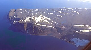
Cape Brewster is a headland in the Greenland Sea, east Greenland, Sermersooq municipality.
Cape J.A.D. Jensen is a headland in the North Atlantic Ocean, east Greenland, Sermersooq municipality. This cape is named after J. A. D. Jensen, an officer of the Danish Navy and Arctic explorer.

Cape Bridgman is a headland in the Wandel Sea, Arctic Ocean, northeast Greenland.

Cape Steen Bille or Kap Bille, also known as Kangeq, is a headland in the North Atlantic Ocean, southeast Greenland, Kujalleq municipality.

Cape Washington is a headland in North Greenland. Administratively it belongs to the Northeast Greenland National Park.
Cape Cannon is a headland in the Lincoln Sea, Arctic Ocean, North Greenland. Administratively it is part of the Northeast Greenland National Park.

Cape James Hill is a headland in the Wandel Sea, Arctic Ocean, northeast Greenland.
Cape Brown is a headland in the Greenland Sea, east Greenland, Sermersooq municipality.
Cape Biot is a headland in the Greenland Sea, Northeast Greenland, Sermersooq municipality.
Cape Simpson is a headland in the Greenland Sea, Northeast Greenland. Administratively it is part of the Northeast Greenland National Park.
Nansen Land is a peninsula in far northwestern Greenland. It is a part of the Northeast Greenland National Park.
Cape Bismarck is a headland in King Frederick VIII Land, Northeast Greenland. Administratively it is part of the Northeast Greenland National Park.
Cape John Flagler is a headland in the Wandel Sea, Arctic Ocean, northeast Greenland. Administratively it is part of the Northeast Greenland National Park.

Cape Henry Parish is a broad headland in the Wandel Sea, Arctic Ocean, northernmost Greenland. Administratively it is part of the Northeast Greenland National Park.
Cape Eiler Rasmussen is a broad headland in the Wandel Sea, Arctic Ocean, northernmost Greenland. Administratively it is part of the Northeast Greenland National Park.

