Labrador Sea Water

Last updated
Map of Labrador Current LabradorCurrentus-coastguard.jpg
Map of Labrador Current

Labrador Sea Water is an intermediate water mass characterized by cold water, relatively low salinity compared to other intermediate water masses, [1] and high concentrations of both oxygen and anthropogenic tracers. [2] It is formed by convective processes in the Labrador Sea [3] located between Greenland and the northeast coast of the Labrador Peninsula. Deep convection in the Labrador Sea allows colder water to sink forming this water mass, which is a contributor to the upper layer of North Atlantic Deep Water. North Atlantic Deep Water flowing southward is integral to the Atlantic Meridional Overturning Circulation. [4] The Labrador Sea experiences a net heat loss to the atmosphere annually.

Contents

Formation

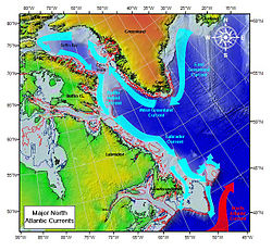
Convection in the Labrador Sea is the result of a combination of cyclonic oceanographic circulation of the sea currents and cyclonic atmospheric forcing. At the southern tip of Greenland, water enters the West Greenland Current from the East Greenland Current, continues to flow northwest around the Baffin Bay, and then southeast into the Baffin Island Current continuing in the same direction in the Labrador Current. Sea ice in the winter months inhibits surface flow into Baffin Bay. The Labrador Current and the Western Greenland Current flow in opposite directions resulting in a cyclonic eddy. During winter months low pressure dominates in this region, [5] and in years with a positive North Atlantic Oscillation deeper convection is observed. [6]

Spreading

Labrador Sea Water spreads through the North Atlantic Ocean by three routes: northeast directly into the Irminger Sea, into the eastern North Atlantic by means of the deep North Atlantic current, and meridionally via the Deep Western Boundary Current. [2] Oceanographer Robert Pickart, in a paper published in 2002, presented data that suggest that the Labrador Sea is not the only formation site for Labrador Sea Water. They observed similar convective processes in the Irminger Sea and noted that transit times for Labrador Sea Water into Irminger Sea were unusually fast, suggesting that there is another source in the Irminger Sea.

Variability

Labrador Sea Water properties experience seasonal and interannual variations. In late spring and summer, large amounts of cold freshwater accumulate from melting ice and are mixed downward during convection. The source for heat in the Labrador Sea is modified North Atlantic Current water after circulating the subpolar gyre. [7] In winter the sea becomes more saline as freshwater freezes to form sea ice. The greatest seasonal variability is largely confined to the surface waters, however an annual cycle of convective mixing and re-stratification is observed throughout the water column. Warming and increased salinity in the lower level and freshening at the surface is associated with re-stratification (May–December), whereas a convective mixing period (January–April) leads to cooling and a decrease in salt content in intermediate and deep waters and an increase in salt content at the surface. Interannual variations in the intermediate Labrador Sea Water are due largely to changes in convection throughout these periods. Weak convective periods are associated with more heat in the water column and deep convective periods are characterized by cold water. In the early 1990s, several consecutive severe winters contributed towards deep convection in the Labrador Sea. These winters were also associated with strong positive fluctuations in the North Atlantic Oscillation. Labrador Sea Water became very cold, fresh, and dense during this period, and the layer extended to depths of 2300m in the spring of 1994. [3] Due to weakened convection, Labrador Sea Water began warming significantly and increased in salinity over the following decade. This trend continued through 2010 and 2011 when weak convection was observed in relation with negative North Atlantic Oscillation. Deep convection was observed again in 2012 with the Labrador Sea Water reaching 1400m, corresponding with a positive North Atlantic Oscillation similar to those seen in the early 1990s.

See also

Related Research Articles

<span class="mw-page-title-main">Atlantic Ocean</span> Ocean between Europe, Africa and the Americas

The Atlantic Ocean is the second-largest of the world's five oceans, with an area of about 85,133,000 km2 (32,870,000 sq mi). It covers approximately 17% of Earth's surface and about 24% of its water surface area. During the Age of Discovery, It was known for separating the "Old World" from the "New World".

<span class="mw-page-title-main">North Atlantic Current</span> Current of the Atlantic Ocean

The North Atlantic Current (NAC), also known as North Atlantic Drift and North Atlantic Sea Movement, is a powerful warm western boundary current within the Atlantic Ocean that extends the Gulf Stream northeastward.

<span class="mw-page-title-main">North Atlantic Deep Water</span> Deep water mass formed in the North Atlantic Ocean

North Atlantic Deep Water (NADW) is a deep water mass formed in the North Atlantic Ocean. Thermohaline circulation of the world's oceans involves the flow of warm surface waters from the southern hemisphere into the North Atlantic. Water flowing northward becomes modified through evaporation and mixing with other water masses, leading to increased salinity. When this water reaches the North Atlantic it cools and sinks through convection, due to its decreased temperature and increased salinity resulting in increased density. NADW is the outflow of this thick deep layer, which can be detected by its high salinity, high oxygen content, nutrient minima, high 14C/12C, and chlorofluorocarbons (CFCs).

<span class="mw-page-title-main">Downwelling</span> Process of accumulation and sinking of higher density material beneath lower density material

Downwelling is the downward movement of a fluid parcel and its properties within a larger fluid. It is closely related to upwelling, the upward movement of fluid.

<span class="mw-page-title-main">Ocean current</span> Directional mass flow of oceanic water generated by external or internal forces

An ocean current is a continuous, directed movement of seawater generated by a number of forces acting upon the water, including wind, the Coriolis effect, breaking waves, cabbeling, and temperature and salinity differences. Depth contours, shoreline configurations, and interactions with other currents influence a current's direction and strength. Ocean currents are primarily horizontal water movements.

<span class="mw-page-title-main">Thermohaline circulation</span> Part of large-scale ocean circulation

Thermohaline circulation (THC) is a part of the large-scale ocean circulation that is driven by global density gradients created by surface heat and freshwater fluxes. The adjective thermohaline derives from thermo- referring to temperature and -haline referring to salt content, factors which together determine the density of sea water. Wind-driven surface currents travel polewards from the equatorial Atlantic Ocean, cooling en route, and eventually sinking at high latitudes. This dense water then flows into the ocean basins. While the bulk of it upwells in the Southern Ocean, the oldest waters upwell in the North Pacific. Extensive mixing therefore takes place between the ocean basins, reducing differences between them and making the Earth's oceans a global system. The water in these circuits transport both energy and mass around the globe. As such, the state of the circulation has a large impact on the climate of the Earth.

<span class="mw-page-title-main">Ocean gyre</span> Any large system of circulating ocean surface currents

In oceanography, a gyre is any large system of circulating ocean surface currents, particularly those involved with large wind movements. Gyres are caused by the Coriolis effect; planetary vorticity, horizontal friction and vertical friction determine the circulatory patterns from the wind stress curl (torque).

<span class="mw-page-title-main">East Greenland Current</span> Current from Fram Strait to Cape Farewell off the eastern coat of Greenland

The East Greenland Current (EGC) is a cold, low-salinity current that extends from Fram Strait (~80N) to Cape Farewell (~60N). The current is located off the eastern coast of Greenland along the Greenland continental margin. The current cuts through the Nordic Seas and through the Denmark Strait. The current is of major importance because it directly connects the Arctic to the Northern Atlantic, it is a major contributor to sea ice export out of the Arctic, and it is a major freshwater sink for the Arctic.

<span class="mw-page-title-main">Labrador Current</span> Cold current in the Atlantic ocean along the coasts of Labrador, Newfoundland and Nova Scotia

The Labrador Current is a cold current in the North Atlantic Ocean which flows from the Arctic Ocean south along the coast of Labrador and passes around Newfoundland, continuing south along the east coast of Canada near Nova Scotia. Near Nova Scotia, this cold water current meets the warm northward moving Gulf Stream. The combination of these two currents produces heavy fogs and has also created one of the richest fishing grounds in the world.

<span class="mw-page-title-main">Atlantic meridional overturning circulation</span> System of surface and deep currents in the Atlantic Ocean

The Atlantic meridional overturning circulation (AMOC) is the "main current system in the South and North Atlantic Oceans". As such, it is a component of Earth's oceanic circulation system and plays an important role in the climate system. If the strength of the AMOC changes this could have impacts on some elements of the climate system. The AMOC includes currents at the surface as well as at great depths in the Atlantic Ocean. These currents are driven by changes in the atmospheric weather as well as by changes in temperature and salinity. They collectively make up one half of the global thermohaline circulation that encompasses the flow of major ocean currents. The other half is the Southern Ocean overturning circulation.

The Irminger Current is a north Atlantic ocean current setting westward off the southwest coast of Iceland. It is composed of relatively warm and saline waters from the eastern North Atlantic that are fed by the North Atlantic Drift. The Irminger Current is part of the North Atlantic subpolar gyre. The current is named after Danish vice-admiral Carl Ludvig Christian Irminger (1802–1888).

<span class="mw-page-title-main">Arctic Ocean</span> Ocean in the north polar region

The Arctic Ocean is the smallest and shallowest of the world's five major oceans. It spans an area of approximately 14,060,000 km2 (5,430,000 sq mi) and is known as one of the coldest of oceans. The International Hydrographic Organization (IHO) recognizes it as an ocean, although some oceanographers call it the Arctic Mediterranean Sea. It has also been described as an estuary of the Atlantic Ocean. It is also seen as the northernmost part of the all-encompassing World Ocean.

The Great Salinity Anomaly (GSA) originally referred to an event in the late 1960s to early 1970s where a large influx of freshwater from the Arctic Ocean led to a salinity anomaly in the northern North Atlantic Ocean, which affected the Atlantic meridional overturning circulation. Since then, the term "Great Salinity Anomaly" has been applied to successive occurrences of the same phenomenon, including the Great Salinity Anomaly of the 1980s and the Great Salinity Anomaly of the 1990s. The Great Salinity Anomalies were advective events, propagating to different sea basins and areas of the North Atlantic, and is on the decadal-scale for the anomalies in the 1970s, 1980s, and 1990s.

<span class="mw-page-title-main">Mode water</span> Type of water mass which is nearly vertically homogeneous

Mode water is defined as a particular type of water mass, which is nearly vertically homogeneous. Its vertical homogeneity is caused by the deep vertical convection in winter. The first term to describe this phenomenon is 18° water, which was used by Valentine Worthington to describe the isothermal layer in the northern Sargasso Sea cool to a temperature of about 18 °C each winter. Then Masuzawa introduced the subtropical mode water concept to describe the thick layer of temperature 16–18 °C in the northwestern North Pacific subtropical gyre, on the southern side of the Kuroshio Extension. The terminology mode water was extended to the thick near-surface layer north of the Subantarctic Front by McCartney, who identified and mapped the properties of the Subantarctic mode water (SAMW). After that, McCartney and Talley then applied the term subpolar mode water (SPMW) to the thick near-surface mixed layers in the North Atlantic’s subpolar gyre.

<span class="mw-page-title-main">Denmark Strait overflow</span> Underwater waterfall in the Atlantic

The Denmark Strait overflow is an undersea overflow located in the Denmark Strait between Greenland and Iceland. The overflow transports around 3.2 million m3 (110 million cu ft) of water per second, greatly eclipsing the discharge of the Amazon River into the Atlantic Ocean and the flow rate of the former Guaíra Falls. The descending column of water is approximately 200 m (660 ft) wide and 200 m (660 ft) thick and descends over a length of around 1,000 km (620 mi). It is formed by the density difference of the water masses either side of the Denmark Strait; the southward-flowing water originating from the Nordic Seas is colder and consequently more dense than the Irminger Sea to the south of the strait. At the Greenland–Iceland Rise – an elevated ridge forming the overflow's apex – the colder water cascades along the seafloor to a depth of around 3,000 m (10,000 ft). Due to the Coriolis effect, the downward flow of water is deflected to the right, resulting in the descending water on the Greenland side of the channel being roughly 1 km (0.62 mi) higher than the opposite side of the channel.

<span class="mw-page-title-main">Overturning in the Subpolar North Atlantic Program</span> International research project

The Overturning in the Subpolar North Atlantic Program (OSNAP) is an international project designed to study the mechanistic link between water mass transformation at high latitudes and the meridional overturning circulation in the North Atlantic (AMOC) on interannual time scales. Though this linkage is evident in climate models on decadal time scales, to date there has been no clear demonstration of AMOC variability in response to changes in deep water formation on interannual and decadal time scales. OSNAP intends to fill that gap by providing a continuous record of the trans-basin fluxes of heat, mass and freshwater for a comparison to records of convective activity and water mass transformation at high latitudes in the North Atlantic.

<span class="mw-page-title-main">Nordic Seas</span>

The Nordic Seas are located north of Iceland and south of Svalbard. They have also been defined as the region located north of the Greenland-Scotland Ridge and south of the Fram Strait-Spitsbergen-Norway intersection. Known to connect the North Pacific and the North Atlantic waters, this region is also known as having some of the densest waters, creating the densest region found in the North Atlantic Deep Water. The deepest waters of the Arctic Ocean are connected to the worlds other oceans through Nordic Seas and Fram Strait. There are three seas within the Nordic Sea: Greenland Sea, Norwegian Sea, and Iceland Sea. The Nordic Seas only make up about 0.75% of the World's Oceans. This region is known as having diverse features in such a small topographic area, such as the mid oceanic ridge systems. Some locations have shallow shelves, while others have deep slopes and basins. This region, because of the atmosphere-ocean transfer of energy and gases, has varying seasonal climate. During the winter, sea ice is formed in the western and northern regions of the Nordic Seas, whereas during the summer months, the majority of the region remains free of ice.

Open ocean convection is a process in which the mesoscale ocean circulation and large, strong winds mix layers of water at different depths. Fresher water lying over the saltier or warmer over the colder leads to the stratification of water, or its separation into layers. Strong winds cause evaporation, so the ocean surface cools, weakening the stratification. As a result, the surface waters are overturned and sink while the "warmer" waters rise to the surface, starting the process of convection. This process has a crucial role in the formation of both bottom and intermediate water and in the large-scale thermohaline circulation, which largely determines global climate. It is also an important phenomena that controls the intensity of the Atlantic Meridional Overturning Circulation (AMOC).

<span class="mw-page-title-main">Faroe-Bank Channel overflow</span> Overflow current from Nordic Seas towards North Atlantic Ocean

Cold and dense water from the Nordic Seas is transported southwards as Faroe-Bank Channel overflow. This water flows from the Arctic Ocean into the North Atlantic through the Faroe-Bank Channel between the Faroe Islands and Scotland. The overflow transport is estimated to contribute to one-third of the total overflow over the Greenland-Scotland Ridge. The remaining two-third of overflow water passes through Denmark Strait, the Wyville Thomson Ridge (0.3 Sv), and the Iceland-Faroe Ridge (1.1 Sv).

<span class="mw-page-title-main">Irminger Rings</span> Ocean eddies in Labrador Sea which influence deep convection

Irminger Rings (IRs) are mesoscale ocean eddies that are formed off the West coast of Greenland and travel southwestwards through the Labrador Sea. Most IRs are anti-cyclonic. There is considerable interest in researching IRs, because they have been hypothesized to influence deep convection in the Labrador sea, and therefore the formation of deep water.

References

  1. Talley, Lynne D., et al. Descriptive Physical Oceanography. Academic Press, 2011, p. 497
  2. 1 2 Pickart, Robert S., et al. "Is Labrador Sea Water formed in the Irminger basin?" Deep-Sea Research Part I: Oceanographic Research Papers 50.1 (2003): 23-52
  3. 1 2 Yashayaev, I.M., et al. "Recent Decline of the Labrador Sea Water." Bedford Institute of Oceanography, 2000
  4. Shcmittner, Andreas, et al. "Introduction: The Ocean's Meridional Overturning Circulation" 2013 http://people.oregonstate.edu/~schmita2/pdf/S/schmittner07agu_intro.pdf
  5. Wallace, John M. and Peter V. Hobbs. Atmospheric Science An Introductory Survey. Academic Press, 2006, p. 17.
  6. IPCC North Atlantic Subpolar Gyre, Laabrador Sea and Nordic Seas 2007 http://www.ipcc.ch/publications_and_data/ar4/wg1/en/ch5s5-3-2-1.html
  7. Straneo, F. "Heat and Freshwater Transport through the Central Labrador Sea." Journal of Physical Oceanography 36 (2005)