Ioah Guyot

Last updated
Ioah Guyot
Micronesia and Marshall islands bathymetry, Ioah (IOAN; Fedorov) Guyot.png
Oceania laea location map.svg
Red triangle with thick white border.svg
Ioah
Location in the Pacific Ocean

Ioah Guyot is a seamount in the Pacific Ocean, close to the Marshall Islands. [1] Part of the Magellan Seamounts, it is a shield volcano that has erupted alkali basalt and hawaiite 87 million years ago, but may have continued erupting into the Miocene. During the Cretaceous, reefs developed on the guyot.

Contents

Geography and geomorphology

The guyot belongs to the Magellan Seamounts [2] which stretch from the Mariana Trench to Ita Mai Tai seamount. [3] It is also known as Fedorov and Ioan/ [4] IOAN, which stands for "Institute of Oceanology of the Academy of Sciences of the USSR". [5] Ita Mai Tai guyot lies south-southeast of Ioah and Pallada guyot north-northwest, [6] other seamounts in the area east of Ioah are Changpogo, Gramberg, Zatonskii and Arirang. [7] There are about 1000 seamounts in the central western Pacific. [3]

Ioah Guyot is a shield volcano [8] [9] with an arcuate shape; the two halves that make it up have dimensions of 110 by 66 kilometres (68 mi × 41 mi) and 83 by 65 kilometres (52 mi × 40 mi). [1] The guyot rises 4.5 kilometres (2.8 mi) from the seafloor to 1,420 metres (4,660 ft) [5] 1,380 metres (4,530 ft) depth, forming a summit plateau with a surface area of 1,380 square kilometres (530 sq mi) [10] that is covered by 25–75-metre (82–246 ft) high hills. [1] The rim of the summit plateau is formed by volcanic rocks on the eastern part of the seamount and by reefal limestones on the western; [11] the reef deposits form a sometimes 5 kilometres (3.1 mi) wide [12] and in total about 200 kilometres (120 mi) long ring around the summit platform of Ioah Guyot [13] and cover an area of about 315 square kilometres (122 sq mi), making it the largest limestone outcrop of the Magellan Seamounts. [14] The lower slopes are gentle but steepen between 1,700–2,000-metre (5,600–6,600 ft) depth. Only the lower slopes are covered with thick sediment layers; the upper slopes have sediment accumulations only in sheltered areas [5] and also feature step-like structures. [1] A number of volcanic cones grew on Ioah and form morphostructures, with a density of about 11.1 vents per 1,000 square kilometres (390 sq mi). [15] [16] Some of these vents form alignments and Ioah lies at the intersection of two strike-slip faults. [17] [9] The seamount rises from the East Mariana Basin over Jurassic seafloor, between the two Ogasawara Fracture Zones. [18] [19] [20]

Composition

Volcanic rocks found on Ioah Guyot include alkali basalt, tholeiite and hawaiite, plus ankaramite, phonolite and trachybasalt; [21] [22] [23] as well as zeolites formed by hydrothermal processes. [21] Breccia and sandstones cover the exposed rocks [5] and formed through the breakup of basaltic rocks. [24] Reef limestones and other carbonates were emplaced on the seamount, followed during the Eocene-Pleistocene by pelagic sediments. [25] Clay deposits on the slopes and turbidites have also been reported. [26]

Ferromanganese crusts on the seamount contain apatite, asbolane, buserite, calcite, clay, feldspar, ferrihydrite, feroxyhyte, goethite, hematite, quartz and todorokite [27] and reach thicknesses of 10 centimetres (3.9 in), [5] although they only cover small sectors of Ioah Guyot. [28] Phosphate-containing minerals were deposited over time on Ioah; presently the guyot contains about 150,000,000–200,000,000 tonnes (150,000,000–200,000,000 long tons; 170,000,000–220,000,000 short tons) of phosphorite ore. [29] Some of these ferromanganese deposits form nodules encased within limestones. [30] Spherules of cosmic origin have been found. [31]

History

The seamount developed about 87 million years ago on the Pacific Plate and is now extinct; [4] its estimated age is placed in a range between 88.5 and 86.2 million years. It was located in the Southern Hemisphere as it formed. [19] [8] Some secondary volcanic cones may be much younger, of Miocene age. [32] The formation of Ioah and the other Magellan Seamounts has been explained by a hotspot that would now be located close to the Rarotonga hotspot, Samoa hotspot and Society hotspot were it still active. [22] [33] [34] Compositionally, volcanic rocks from Ioah resemble these of the Rarotonga hotspot. [35]

During the Aptian-Cenomanian, limestones and volcanic rocks formed sediments on Ioah Guyot which developed a reef system. [36] A secondary reefal phase occurred during Santonian to Maastrichtian times [21] and a third one during the Eocene. [37] Ioah developed the largest reefs of the Magellan Seamounts, [2] with coral material accumulating to thicknesses of 200–300 metres (660–980 ft). [23] During the Eocene, tuffs were emplaced on the seamount. [38] Ferromanganese crusts developed later during the Paleogene [39] and Miocene-Pleistocene, [40] and up to 150 metres (490 ft) sediments accumulated on the summit plateau. [11]

Biology

Species that lived on Ioah Guyot during the Cretaceous include ammonoids, belemnites, [41] bivalves, bryozoans, cephalopods, corals, crinoids, foraminifera, gastropods, rudists, sea pens, [23] [42] [43] sea urchins [5] and sponges. [23] Presently, a rich fauna has been identified on Ioah Guyot, including scleractinian corals without zooxanthelles such as Fungiacyathus pliciseptus and Peponocyathus australiensis which is usually found in much shallower waters. [18] [25] [44]

See also

Related Research Articles

<span class="mw-page-title-main">Macdonald hotspot</span> Volcanic hotspot in the southern Pacific Ocean

The Macdonald hotspot is a volcanic hotspot in the southern Pacific Ocean. The hotspot was responsible for the formation of the Macdonald Seamount, and possibly the Austral-Cook Islands chain. It probably did not generate all of the volcanism in the Austral and Cook Islands as age data imply that several additional hotspots were needed to generate some volcanoes.

<span class="mw-page-title-main">Arago hotspot</span> Hotspot in the Pacific Ocean

Arago hotspot is a hotspot in the Pacific Ocean, presently located below the Arago seamount close to the island of Rurutu, French Polynesia.

Magellan Rise is an oceanic plateau in the Pacific Ocean, which covers a surface area of 500,000 square kilometres (190,000 sq mi). There is another "Magellan Rise" west from the Marshall Islands as well.

<span class="mw-page-title-main">Wōdejebato</span> Guyot in the Marshall Islands northwest of the smaller Pikinni Atoll

Wōdejebato is a Cretaceous guyot or tablemount in the northern Marshall Islands, Pacific Ocean. Wōdejebato is probably a shield volcano and is connected through a submarine ridge to the smaller Pikinni Atoll 74 kilometres (46 mi) southeast of the guyot; unlike Wōdejebato, Pikinni rises above sea level. The seamount rises for 4,420 metres (14,500 ft) to 1,335 metres (4,380 ft) depth and is formed by basaltic rocks. The name Wōdejebato refers to a sea god of Pikinni.

<span class="mw-page-title-main">Limalok</span> Cretaceous-Paleocene guyot in the Marshall Islands

Limalok is a Cretaceous-Paleocene guyot/tablemount in the southeastern Marshall Islands, one of a number of seamounts in the Pacific Ocean. It was probably formed by a volcanic hotspot in present-day French Polynesia. Limalok lies southeast of Mili Atoll and Knox Atoll, which rise above sea level, and is joined to each of them through a volcanic ridge. It is located at a depth of 1,255 metres (4,117 ft) and has a summit platform with an area of 636 square kilometres (246 sq mi).

<span class="mw-page-title-main">Lo-En</span> Albian–Campanian guyot in the Marshall Islands in the Pacific Ocean

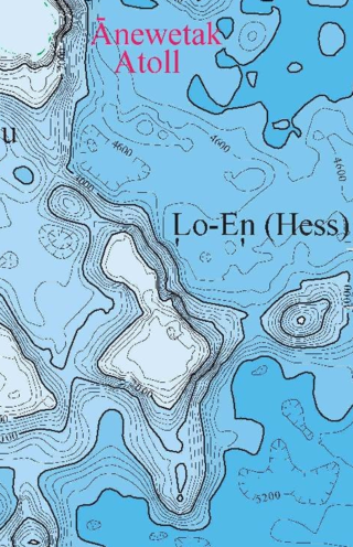
Lo-En or Hess is an Albian–Campanian guyot in the Marshall Islands. One among a number of seamounts in the Pacific Ocean, it was probably formed by a hotspot in what is present-day French Polynesia. Lo-En lies southeast of Eniwetok which rises above sea level, and Lo-En is almost connected to it through a ridge.

<span class="mw-page-title-main">Ruwitūn̄tūn̄</span> Guyot in the Marshall Islands in the Pacific Ocean

Ruwitūn̄tūn̄ is a guyot in the Pacific Ocean which reaches a depth of 1,215 metres (3,986 ft) below sea level. It is capped off with a summit platform covered in sediments and some volcanic pinnacles with craters. Basaltic rocks have been found on Ruwitūn̄tūn̄.

MIT Guyot is a guyot in the Pacific Ocean that rises to a depth of 1,323 metres (4,341 ft). It has a 20-kilometre-long (12 mi) summit platform and formed during the Cretaceous in the region of present-day French Polynesia through volcanic eruptions.

<span class="mw-page-title-main">Pako Guyot</span> Guyot in the Pacific Ocean

Pako Guyot is a guyot in the Pacific Ocean.

<span class="mw-page-title-main">Ita Mai Tai</span>

Ita Mai Tai is a Cretaceous-early Cenozoic seamount northwest of the Marshall Islands and north of Micronesia. One among a number of seamounts in the Pacific Ocean, it is part of the Magellan Seamounts which may have a hotspot origin although Ita Mai Tai itself may not have formed on a hotspot.

<span class="mw-page-title-main">Rarotonga hotspot</span> Volcanic hotspot in the southern Pacific Ocean

The Rarotonga hotspot is a volcanic hotspot in the southern Pacific Ocean. The hotspot was responsible for the formation of Rarotonga and some volcanics of Aitutaki.

<span class="mw-page-title-main">Resolution Guyot</span> Underwater tablemount in the Pacific Ocean

Resolution Guyot is a guyot (tablemount) in the underwater Mid-Pacific Mountains in the Pacific Ocean. It is a circular flat mountain, rising 500 metres (1,600 ft) above the seafloor to a depth of about 1,320 metres (4,330 ft), with a 35 kilometres (22 mi) wide summit platform. The Mid-Pacific Mountains lie west of Hawaii and northeast of the Marshall Islands, but at the time of its formation the guyot was located in the Southern Hemisphere.

<span class="mw-page-title-main">Horizon Guyot</span> Tablemount in the Pacific Ocean

Horizon Guyot is a presumably Cretaceous guyot (tablemount) in the Mid-Pacific Mountains, Pacific Ocean. It is an elongated ridge, over 300 kilometres (190 mi) long and 4.3 kilometres (2.7 mi) high, that stretches in a northeast-southwest direction and has two flat tops; it rises to a minimum depth of 1,443 metres (4,730 ft). The Mid-Pacific Mountains lie west of Hawaii and northeast of the Line Islands.

Allison Guyot is a tablemount (guyot) in the underwater Mid-Pacific Mountains of the Pacific Ocean. It is a trapezoidal flat mountain rising 1,500 metres above the seafloor to a depth of less than 1,500 m, with a summit platform 35 by 70 kilometres wide. The Mid-Pacific Mountains lie west of Hawaii and northeast of the Marshall Islands, but at the time of their formation were located in the Southern Hemisphere.

<span class="mw-page-title-main">Ujlān volcanic complex</span>

Ujlān volcanic complex is a group of seamounts in the Marshall Islands. The complex consists of the seamounts Ļajutōkwa, Ļalibjet, Likelep, Ļotāb and Ujlān which with a minimum depth of 1,250 metres (4,100 ft) is the shallowest part of the complex; sometimes Ujelang Atoll is also considered to be a part of the complex; Eniwetok atoll and Lo-En seamount form a cluster together with this volcanic complex.

Vlinder Guyot is a guyot in the Western Pacific Ocean. It rises to a depth of 1,500 metres (4,900 ft) and has a flat top covering an area of 40 by 50 kilometres. On top of this flat top lie some volcanic cones, one of which rises to a depth of 551 metres (1,808 ft) below sea level. Vlinder Guyot has noticeable rift zones, including an older and lower volcano to the northwest and Oma Vlinder seamount south.

<span class="mw-page-title-main">Vailuluʻu</span> Volcanic seamount in the Samoa Islands

Vailuluʻu is a volcanic seamount discovered in 1975. It rises from the sea floor to a depth of 593 m (1,946 ft) and is located between Taʻu and Rose islands at the eastern end of the Samoa hotspot chain. The basaltic seamount is considered to mark the current location of the Samoa hotspot. The summit of Vailuluʻu contains a 2 km wide, 400 m deep oval-shaped caldera. Two principal rift zones extend east and west from the summit, parallel to the trend of the Samoan hotspot. A third less prominent rift extends southeast of the summit.

Tropic Seamount is a Cretaceous seamount, part of the Canary Islands Seamount Province. It is located west of the Western Sahara's coastline and southwest of the Canary Islands, north of Cape Verde. It is one of a number of seamounts in this part of the Atlantic Ocean, probably formed by volcanic processes triggered by the proximity to the African continent. Tropic Seamount is located at a depth of 970 metres (3,180 ft) and has a summit platform with an area of 120 square kilometres (46 sq mi).

<span class="mw-page-title-main">Capricorn Seamount</span>

Capricorn Seamount is a seamount in Tonga. It rises 4 kilometres (2.5 mi) to a depth of about 360 m (1,180 ft) and is capped off by a 15 km (9.3 mi) wide summit platform. It appears to be a submerged volcano of Miocene age that may be part of a volcanic chain with Niue. Capricorn Seamount is located on the eastern flank of the Tonga Trench and is in the process of breaking up; in turn the trench has been altered by the interaction with the downgoing seamount.

References

  1. 1 2 3 4 Mel'nikov, Pletnev & Basov 2006, p. 4.
  2. 1 2 Mel'nikov, Tugolesov & Pletnev 2010, p. 589.
  3. 1 2 Mel'nikov, Pletnev & Basov 2006, p. 3.
  4. 1 2 "Ioah Seamount". Seamount Catalog. Retrieved 13 September 2018.
  5. 1 2 3 4 5 6 Bogdanov et al. 1987, p. 971.
  6. Asavin, A. M.; Kubrakova, I. V.; Mel’nikov, M. E.; Tyutyunnik, O. A.; Chesalova, E. I. (May 2010). "Geochemical zoning in ferromanganese crusts of Ita-MaiTai guyot". Geochemistry International. 48 (5): 425. doi:10.1134/s0016702910050010. ISSN   0016-7029. S2CID   129118428.
  7. Mel'nikov et al. 2016, p. 4.
  8. 1 2 Glasby et al. 2007, p. 317.
  9. 1 2 Utkin, V. P. (June 2006). "Role of strike-slip faulting of the oceanic lithosphere in the formation of pacific volcanic belts". Doklady Earth Sciences. 409 (1): 693. Bibcode:2006DokES.409..692U. doi:10.1134/S1028334X06050023. S2CID   128625849.
  10. Okamoto, Nobuyuki; Usui, Akira (4 March 2014). "Regional Distribution of Co-Rich Ferromanganese Crusts and Evolution of the Seamounts in the Northwestern Pacific". Marine Georesources & Geotechnology. 32 (3): 194. doi:10.1080/1064119x.2013.877110. ISSN   1064-119X. S2CID   128677808.
  11. 1 2 Mel'nikov, Pletnev & Basov 2006, p. 5.
  12. Pletnev 2021, p. 75.
  13. Pletnev 2019, p. 438.
  14. Pletnev 2021, p. 72.
  15. Mel'nikov, Tugolesov & Pletnev 2010, p. 586.
  16. Mel'nikov et al. 2016, p. 437.
  17. Mel'nikov et al. 2016, p. 441.
  18. 1 2 Keller & Shcherba 2006, p. 240.
  19. 1 2 Glasby et al. 2007, p. 316.
  20. Koppers et al. 1998, p. 56.
  21. 1 2 3 Zakharov et al. 2012, p. 147.
  22. 1 2 Koppers et al. 1998, p. 55.
  23. 1 2 3 4 Mel'nikov, Pletnev & Basov 2006, p. 6.
  24. Bogdanov et al. 1987, p. 977.
  25. 1 2 Keller & Shcherba 2006, p. 238.
  26. Pletnev 2019, p. 443.
  27. Glasby et al. 2007, p. 320.
  28. Bogdanov et al. 1987, p. 976.
  29. Glasby et al. 2007, p. 319.
  30. Mel'nikov et al. 2016, p. 5.
  31. Savelyev, D. P.; Khanchuk, A. I.; Savelyeva, O. L.; Moskaleva, S. V.; Mikhailik, P. E. (1 April 2020). "First Find of Platinum in Cosmogenic Spherules of Ferromanganese Crusts (Fedorov Guyot, Magellan Seamounts, Pacific Ocean)". Doklady Earth Sciences. 491 (2): 199. Bibcode:2020DokES.491..199S. doi:10.1134/S1028334X20040157. ISSN   1531-8354. S2CID   219638248.
  32. Mel'nikov et al. 2016, p. 439.
  33. Koppers et al. 2003, p. 19.
  34. Koppers et al. 1998, p. 66.
  35. Koppers et al. 2003, p. 25.
  36. Zakharov et al. 2012, p. 146.
  37. Pletnev 2021, p. 81.
  38. Pletnev 2021, p. 80.
  39. Bogdanov et al. 1987, p. 982.
  40. Bogdanov et al. 1987, p. 981.
  41. Zakharov et al. 2012, p. 145.
  42. Zakharov et al. 2012, pp. 146–147.
  43. Reich, Mike; Kutscher, Manfred (2015). "Sea pens (Octocorallia: Pennatulacea) from the Late Cretaceous of northern Germany". Journal of Paleontology. 85 (6): 1043. doi:10.1666/10-109.1. ISSN   0022-3360. S2CID   130123892.
  44. Keller & Shcherba 2006, p. 239.

Sources