Coral Patch Seamount

Last updated • 6 min readFrom Wikipedia, The Free Encyclopedia

Coral Patch Seamount
Coral Patch Seamount, bathymetric map.PNG
Bathymetric map of Coral Patch Seamount
Location
Location Atlantic Ocean
Coordinates 34°56′N11°57′W / 34.933°N 11.950°W / 34.933; -11.950 [1]

Coral Patch Seamount is a seamount (underwater mountain) between Madeira and mainland Portugal in the North Atlantic Ocean. It is an elongated 120 kilometres (75 mi) long and 70 kilometres (43 mi) wide mountain that rises to a depth of about 645 metres (2,116 ft), with nine volcanic cones on its summit. It has steeper southern slopes and a gentle northern slope. To its west lies Ampére Seamount, and together with several neighbouring seamounts it is one of the Horseshoe Seamounts.

Contents

The seamount was probably formed by the Madeira hotspot in the Miocene, together with buckling processes in the oceanic crust. It was initially probably an island. There is evidence of submarine landslides and active faults which constitute a tsunami hazard; the 1755 Lisbon earthquake may have occurred north of the seamount.

The name Coral Patch Seamount refers to the presence of cold water corals on the seamount. Their occurrence there was reported first in 1878, five years before the actual discovery of the seamount. They are only sparse on Coral Patch Seamount, probably due to lack of nutrients. A number of other submarine animals including fish have been observed.

Research history and name

An expedition by the CS Dacia laying a deep sea cable between the Canary Islands and Cadiz discovered the seamount on October 12, 1883. The name is a reference to cold water corals dredged from the seamount; their occurrence was reported in 1878. The seamount was originally named "Coral Patch shoal": the term seamount was not yet in use at that time. [2] [3] It is only poorly explored. [4]

Geography and geomorphology

Seamounts of the north-east Atlantic Ocean SMT of the NE Atlantic-Ocean.svg
Seamounts of the north-east Atlantic Ocean

A number of seamounts exist in the northeastern Atlantic around the Azores, the Canary Islands and Madeira. They rise between abyssal plains from a seafloor at 4,000–4,800 metres (13,100–15,700 ft) to depths of usually a few hundred meters below sea level. [2] They are known as the Horseshoe Seamounts. [5]

Together with Ampére Seamount farther west Coral Patch Seamount forms the Ampére bank: [2] a 3,400 metres (11,200 ft) deep valley separates the two. [6] To the northeast lies Coral Patch Ridge [7] and north Gorringe Ridge, across the Horseshoe Abyssal Plain. The Seine Hills are located east of Coral Patch Seamount. [8]

Coral Patch Seamount has an elliptical outline, 120 kilometres (75 mi) long and 70 kilometres (43 mi) wide and trending east-northeast. [2] The shallowest point lies at a depth of about 645 metres (2,116 ft). [9] It consists of nine volcanic cones that overlie a sedimentary structural high; the cones and the structural high make up the seamount. The 8 kilometres (5.0 mi) wide 'Vince volcano' is the largest volcanic cone and forms a solitary northeasterly summit; the other eight are clustered in the southwest and one of these forms the shallowest point of the seamount. [2] [7] The southern slopes are steep and feature canyon-like features, the northern slopes are more gentle. [9] Two faults, the North Coral Patch Ridge fault and the South Coral Patch Ridge fault, run northeastward away from Coral Patch Seamount. [10] Both have offset Holocene deposits and thus appear to be active. [11] Thrust faults separate Coral Patch Seamount from the Horseshoe Abyssal Plain. [12]

The surface of the seamount is formed mainly by outcropping basaltic bedrock while sediment deposits are of secondary importance. Outcropping rocks are weathered and often altered by biological activity: sediments occur mainly in depressions [13] and are largely absent on the upper part of the seamount. [14] Most of the sediments appear to originate locally, either from biological activity or as carbonates. [15] Antiforms, gullies and scarps occur on the seamount, the latter are evidence of past submarine landslides or mass wasting phenomena. [7]

Geology

The Madeira hotspot is considered to be responsible for the formation of a 700 kilometres (430 mi) long chain of seamounts going from the 72 million years old Serra de Monchique in Iberia to the 14-0 million years old Porto Santo and Madeira, [16] including Coral Patch Seamount. [12] The plate motion history of the region is complicated and some seamounts formed off-track through pulsations of the mantle plume or through lithospheric anomalies. [16] Buckling of the crust due to plate convergence is also responsible for the uplift of Coral Patch Seamount [17] and has pushed it over the Horseshoes Abyssal Plain. [12]

A depiction of the Great Lisbon Earthquake of 1 November 1755, the epicentre of which may have been located between Coral Patch Seamount and Gorringe Bank Earthquake at Lisbon.jpg
A depiction of the Great Lisbon Earthquake of 1 November 1755, the epicentre of which may have been located between Coral Patch Seamount and Gorringe Bank

Efforts at radiometric dating on Coral Patch Seamount have been unsuccessful, but fossil remains indicate that the seamount was volcanically active in the early Miocene together with the neighbouring Ampére Seamount, [18] and a date of 31.2 ± 0.2 million years ago has been obtained for the Ampére-Coral Patch ridge. [19] Both seamounts were probably islands in the past. [20] The volcanic growth of the seamount was influenced by the wider tectonic regime, resulting in the east-northeast trending structure of the seamount. The tectonic regime would have favoured the ascent of magma from the Madeira hotspot away from its usual track. [21]

In the present-day, the region of Coral Patch Seamount is a potential source for tsunamis including a transatlantic tsunami on March 31, 1761: [22] an earthquake was recorded close to the seamount on July 11, 1915. [23] In addition, the most common hypotheses for the source of the 1755 Lisbon earthquake localize it in the area between Coral Patch Seamount and Gorringe Bank. [24]

Dredging has recovered volcanic rocks from the seamount, including volcanic breccia, hyaloclastites, and lavas, [16] which occur both in the form of slabs [25] and pillow lavas. [3] The volcanic rocks are alkali basalts, [26] basalts and hawaiites containing clinopyroxene, diopside and olivine phenocrysts and are heavily altered [27] with the formation of palagonite and zeolites. [26] Their geochemistry indicates that the magma forming them was influenced by crustal components. [19] Nonvolcanic rocks include pelagic carbonates, [3] biogenic carbonates generated by animal skeletons and foraminifera, [28] limestones and iron-manganese oxides. [18]

Life

Examples of fauna observed at Coral Patch Seamount Animals from Coral Patch Seamount.png
Examples of fauna observed at Coral Patch Seamount

Many seamounts are biodiversity hotspots, as they interact with ocean currents enhancing the biological productivity around them. In the case of the northeast Atlantic seamounts, deep ocean currents are diverted at the seamount inducing upwelling. Outcropping rocks permit the settlement of species that would not find suitable substrates on sediment covered seafloor. [2]

Underwater video has identified a number of animals living on Coral Patch Seamount, but in general animals are rare and corals do not form large colonies. [13] These include actinians, anemones, asteroids, barnacles, bivalves, [lower-alpha 1] brachiopods, dendrophylliid corals, [30] Eguchipsammia , [31] Lophelia pertusa and Madrepora oculata corals, crinoids, echinoids, octocorals, and sponges, most of which are attached to bedrock. [30] Crinoids and hydrozoans settle on corals. [25] Mobile animals include annelid serpulids, the crab Mediterranean geryon, the fish Atlantic wreckfish, blackbellied angler, rattails and silver roughy, gastropods and shrimps. [30] Most animals on Coral Patch Seamount appear to be suspension feeders. [4]

The seamount is heavily fished. Underwater observations have found numerous fishing lines and other debris from human activity on Coral Patch Seamount. [32] Fishing may be the reason why there are few animals on the seamount; a lack of nutrients may be another reason. [33] Rocks dredged from Coral Patch Seamount feature evidence of endolithic microorganisms, i.e., microorganisms that live within the rock. [34] This evidence may yield cues about the identification of past life on Mars, as the basaltic rocks could be a suitable environment. [35]

Notes

  1. A number of bivalve species have been first discovered on Coral Patch Seamount, including Ancistrobasis lavaleyei, Basilissopsis vanheugteni, Chrysallida intorta, Fusceulima coralensis, Fusceulima victorhensenae and Papuliscala lydiae. [29]

Related Research Articles

Adams Seamount is a submarine volcano above the Pitcairn hotspot in the central Pacific Ocean about 100 kilometres (62 mi) southwest of Pitcairn Island.

<span class="mw-page-title-main">Anton Dohrn Seamount</span> Guyot in the Rockall Trough in the northeast Atlantic

The Anton Dohrn Seamount is a guyot in the Rockall Trough in the northeast Atlantic. It is 1.8 kilometres (1.1 mi) high and is topped with pinnacles, one of which reaches a depth of 530 metres (1,740 ft). Away from the flat top upon which the pinnacles rest, the slopes fall off steeply into the Rockall Trough and a moat in the sediment that surrounds the seamount.

The Azores–Gibraltar Transform Fault (AGFZ), also called a fault zone and a fracture zone, is a major seismic zone in the Eastern Atlantic Ocean between the Azores and the Strait of Gibraltar. It is the product of the complex interaction between the African, Eurasian, and Iberian plates. The AGFZ produced these large-magnitude earthquakes and, consequently, a number of large tsunamis: 1755 Lisbon, 1761 Lisbon, 1816 North Atlantic, 1941 Gloria Fault earthquake, 1969 Horseshoe and 1975.

Foundation Seamounts are a series of seamounts in the southern Pacific Ocean. Discovered in 1992, these seamounts form a 1,350 kilometres (840 mi) long chain which starts from the Pacific-Antarctic Ridge. Some of these seamounts may have once emerged from the ocean.

Macdonald seamount is a seamount in Polynesia, southeast of the Austral Islands and in the neighbourhood of a system of seamounts that include the Ngatemato seamounts and the Taukina seamounts. It rises 4,200 metres (13,800 ft) from the seafloor to a depth of about 40 metres (130 ft) and has a flat top, but the height of its top appears to vary with volcanic activity. There are some subsidiary cones such as Macdocald seamount. The seamount was discovered in 1967 and has been periodically active with gas release and seismic activity since then. There is hydrothermal activity on Macdonald, and the vents are populated by hyperthermophilic bacteria.

The Discovery Seamounts are a chain of seamounts in the Southern Atlantic Ocean, including Discovery Seamount. The seamounts are 850 kilometres (530 mi) east of Gough Island and once formed islands. Various volcanic rocks as well as glacial dropstones and sediments have been dredged from the Discovery Seamounts.

<span class="mw-page-title-main">Vema Seamount</span> Seamount in the South Atlantic east of Cape Town

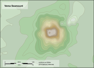
Vema Seamount is a seamount in the South Atlantic Ocean. Discovered in 1959 by a ship with the same name, it lies 1,600 kilometres (1,000 mi) from Tristan da Cunha and 1,000 kilometres (620 mi) northwest of Cape Town. The seamount has a flat top at a mean depth of 73 metres which was eroded into the seamount at a time when sea levels were lower; the shallowest point lies at 26 metres depth. The seamount was formed between 15-11 million years ago, possibly by a hotspot.

<span class="mw-page-title-main">Noronha hotspot</span>

Noronha hotspot is a hypothesized hotspot in the Atlantic Ocean. It has been proposed as the candidate source for volcanism in the Fernando de Noronha archipelago of Brazil, as well as of other volcanoes also in Brazil and even the Bahamas and the Central Atlantic Magmatic Province.

<span class="mw-page-title-main">Wōdejebato</span> Guyot in the Marshall Islands northwest of the smaller Pikinni Atoll

Wōdejebato is a Cretaceous guyot or tablemount in the northern Marshall Islands, Pacific Ocean. Wōdejebato is probably a shield volcano and is connected through a submarine ridge to the smaller Pikinni Atoll 74 kilometres (46 mi) southeast of the guyot; unlike Wōdejebato, Pikinni rises above sea level. The seamount rises for 4,420 metres (14,500 ft) to 1,335 metres (4,380 ft) depth and is formed by basaltic rocks. The name Wōdejebato refers to a sea god of Pikinni.

<span class="mw-page-title-main">Limalok</span> Cretaceous-Paleocene guyot in the Marshall Islands

Limalok is a Cretaceous-Paleocene guyot/tablemount in the southeastern Marshall Islands, one of a number of seamounts in the Pacific Ocean. It was probably formed by a volcanic hotspot in present-day French Polynesia. Limalok lies southeast of Mili Atoll and Knox Atoll, which rise above sea level, and is joined to each of them through a volcanic ridge. It is located at a depth of 1,255 metres (4,117 ft) and has a summit platform with an area of 636 square kilometres (246 sq mi).

<span class="mw-page-title-main">Lo-En</span> Albian–Campanian guyot in the Marshall Islands in the Pacific Ocean

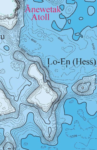
Lo-En or Hess is an Albian–Campanian guyot in the Marshall Islands. One among a number of seamounts in the Pacific Ocean, it was probably formed by a hotspot in what is present-day French Polynesia. Lo-En lies southeast of Eniwetok which rises above sea level, and Lo-En is almost connected to it through a ridge.

MIT Guyot is a guyot in the Pacific Ocean that rises to a depth of 1,323 metres (4,341 ft). It has a 20-kilometre-long (12 mi) summit platform and formed during the Cretaceous in the region of present-day French Polynesia through volcanic eruptions.

<span class="mw-page-title-main">Ioah Guyot</span> Seamount in the Pacific Ocean

Ioah Guyot is a seamount in the Pacific Ocean, close to the Marshall Islands. Part of the Magellan Seamounts, it is a shield volcano that has erupted alkali basalt and hawaiite 87 million years ago, but may have continued erupting into the Miocene. During the Cretaceous, reefs developed on the guyot.

<span class="mw-page-title-main">Vesteris Seamount</span> Seamount in the North Atlantic Ocean

Vesteris Seamount, also known as Vesteris Bank, is a seamount in the Greenland Sea of the North Atlantic Ocean between Greenland and Norway. It lies north of Jan Mayen and rises from 41–43 million years old ocean crust. The reasons for the volcanic activity at Vesteris are unclear and may involve lithospheric processes.

<span class="mw-page-title-main">Ita Mai Tai</span> Seamount in the Pacific Ocean

Ita Mai Tai is a Cretaceous-early Cenozoic seamount northwest of the Marshall Islands and north of Micronesia. One among a number of seamounts in the Pacific Ocean, it is part of the Magellan Seamounts which may have a hotspot origin although Ita Mai Tai itself may not have formed on a hotspot.

Echo Bank is an underwater mountain, part of the Canary Islands Seamount Province and located southwest of the Canary Islands. Of uncertain geologic origin, it is part of a larger cluster of submarine mountains and rises to a depth of 255 metres (837 ft) below sea level. It has a flat top, indicating that it formerly might have emerged from the sea.

Tropic Seamount is a Cretaceous seamount, part of the Canary Islands Seamount Province. It is located west of the Western Sahara's coastline and southwest of the Canary Islands, north of Cape Verde. It is one of a number of seamounts in this part of the Atlantic Ocean, probably formed by volcanic processes triggered by the proximity to the African continent. Tropic Seamount is located at a depth of 970 metres (3,180 ft) and has a summit platform with an area of 120 square kilometres (46 sq mi).

Researcher Ridge is an underwater ridge in the Northern Atlantic Ocean. It appears to be a chain of seamounts named Gollum Seamount, Vayda Seamount, Bilbo Seamount, Gandalf Seamount, The Shire Seamount, Pippin Seamount, Merry Seamount, Molodezhnaya Seamount, Frodo Seamount, Sam Seamount and Mount Doom Seamount that were likely formed by a hotspot.

<span class="mw-page-title-main">Krylov Seamount</span> Seamount in the Atlantic Ocean

Krylov Seamount is a volcanic seamount in the Atlantic Ocean, west of the Cape Verde islands. It is formed by one seamount and one ridge which are separated by a 5 kilometres (3.1 mi) wide depression, and it rises to a minimum depth of 1,240 metres (4,070 ft); formerly the depression was interpreted to be a caldera. The seamount probably formed no later than 70-75 million years ago before sinking to its current depth.

South Arch volcanic field is an underwater volcanic field south of Hawaiʻi Island. It was active during the last 10,000 years, and covers an area of 35 by 50 kilometres at a depth of 4,950 metres (16,240 ft).

References

  1. "Seamounts Catalog". Earthref, a National Science Foundation project. Retrieved December 28, 2009.
  2. 1 2 3 4 5 6 Wienberg et al. 2013, p. 3422.
  3. 1 2 3 Hoffman & Freiwald 2017, p. 61.
  4. 1 2 Morato, T.; Kvile, K. Ø; Taranto, G. H.; Tempera, F.; Narayanaswamy, B. E.; Hebbeln, D.; Menezes, G. M.; Wienberg, C.; Santos, R. S.; Pitcher, T. J. (May 6, 2013). "Seamount physiography and biology in the north-east Atlantic and Mediterranean Sea". Biogeosciences. 10 (5): 3048. Bibcode:2013BGeo...10.3039M. doi: 10.5194/bg-10-3039-2013 . ISSN   1726-4170.
  5. Wienberg et al. 2013, p. 3423.
  6. Christiansen, Bernd; Vieira, Rui P.; Christiansen, Sabine; Denda, Anneke; Oliveira, Frederico; Gonçalves, Jorge M. S. (October 2, 2014). "The fish fauna of Ampère Seamount (NE Atlantic) and the adjacent abyssal plain". Helgoland Marine Research. 69 (1): 13. doi: 10.1007/s10152-014-0413-4 .
  7. 1 2 3 D'Oriano et al. 2010, p. 496.
  8. Martínez-Loriente et al. 2013, p. 2209.
  9. 1 2 Wienberg et al. 2013, p. 3435.
  10. Martínez-Loriente et al. 2013, p. 2211.
  11. Figueiredo, Paula M.; Cabral, João; Rockwell, Thomas K. (February 21, 2014). "Recognition of Pleistocene marine terraces in the southwest of Portugal (Iberian Peninsula): evidences of regional Quaternary uplift". Annals of Geophysics. 56 (6): 3. doi: 10.4401/ag-6276 . ISSN   2037-416X.
  12. 1 2 3 Vazquez, J. T.; Alonso, B.; Fernandez-Puga, M. C.; Gomez-Ballesteros, M.; Iglesias, J.; Palomino, D.; Roque, C.; Ercilla, G.; Diaz-del-Rio, V. (2015). "Seamounts along the Iberian continental margins". Boletin Geologico y Minero. 126 (2–3): 502 via ResearchGate.
  13. 1 2 Wienberg et al. 2013, p. 3433.
  14. Hebbeln et al. 2008, p. 9.
  15. Wienberg et al. 2013, p. 3437.
  16. 1 2 3 D'Oriano et al. 2010, p. 494.
  17. Sartori, R.; Torelli, L.; Zitellini, N.; Peis, D.; Lodolo, E. (June 1, 1994). "Eastern segment of the Azores-Gibraltar line (central-eastern Atlantic) : An oceanic plate boundary with diffuse compressional deformation". Geology. 22 (6): 557. Bibcode:1994Geo....22..555S. doi:10.1130/0091-7613(1994)022<0555:ESOTAG>2.3.CO;2. ISSN   0091-7613.
  18. 1 2 D'Oriano et al. 2010, p. 498.
  19. 1 2 Merle, Renaud; Schärer, Urs; Girardeau, Jacques; Cornen, Guy (October 1, 2006). "Cretaceous seamounts along the continent–ocean transition of the Iberian margin: U–Pb ages and Pb–Sr–Hf isotopes". Geochimica et Cosmochimica Acta. 70 (19): 4953. Bibcode:2006GeCoA..70.4950M. doi:10.1016/j.gca.2006.07.004. ISSN   0016-7037.
  20. Geldmacher, Jörg; van den Bogaard, Paul; Hoernle, Kaj; Schmincke, Hans-Ulrich (February 2000). "The Ar/ Ar age dating of the Madeira Archipelago and hotspot track (eastern North Atlantic)" (PDF). Geochemistry, Geophysics, Geosystems. 1 (2): 21. doi:10.1029/1999GC000018. S2CID   56278515.
  21. D'Oriano et al. 2010, p. 499.
  22. Wronna, Baptista & Miranda 2019, p. 337.
  23. Wronna, Baptista & Miranda 2019, p. 340.
  24. Grandin, Raphaël; Borges, José Fernando; Bezzeghoud, Mourad; Caldeira, Bento; Carrilho, Fernando (November 1, 2007). "Simulations of strong ground motion in SW Iberia for the 1969 February 28 (Ms = 8.0) and the 1755 November 1 (M~ 8.5) earthquakes - II. Strong ground motion simulations". Geophysical Journal International. 171 (2): 816. Bibcode:2007GeoJI.171..807G. doi: 10.1111/j.1365-246X.2007.03571.x . ISSN   0956-540X.
  25. 1 2 Hebbeln et al. 2008, p. 54.
  26. 1 2 Cavalazzi, Westall & Barbieri 2008, p. 178.
  27. D'Oriano et al. 2010, p. 497.
  28. Hoffman & Freiwald 2017, p. 63.
  29. Hoffman & Freiwald 2017, pp. 63–68.
  30. 1 2 3 Wienberg et al. 2013, p. 3429,3431.
  31. Tempera, F.; Carreiro-Silva, M.; Jakobsen, K.; Porteiro, F. M.; Braga-Henriques, A.; Jakobsen, J. (March 1, 2015). "An Eguchipsammia (Dendrophylliidae) topping on the cone". Marine Biodiversity. 45 (1): 3. Bibcode:2015MarBd..45....3T. doi:10.1007/s12526-014-0220-9. ISSN   1867-1624. S2CID   45455733.
  32. Wienberg et al. 2013, p. 3434.
  33. Wienberg et al. 2013, p. 3439.
  34. Cavalazzi, Westall & Barbieri 2008, p. 181.
  35. Allen, Carlton; Beaty, David W. (February 13–15, 2012). BIOSIGNATURES IN VESCICULAR BASALTS. Conference on Life Detection in Extraterrestrial Samples. San Diego, California: Lunar and Planetary Institute.

Sources