Brunei is a country in Southeast Asia, bordering the South China Sea and East Malaysia. Its geographical coordinates are 4°30′N114°40′E. The country is small with a total size of 5,765 km2 (2,226 sq mi). It is larger in size than Trinidad and Tobago. It is close to vital sea lanes through the South China Sea linking the Indian and Pacific Oceans. The country has two parts physically separated by Malaysia, making it almost an enclave within Malaysia.
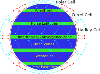
The horse latitudes are the latitudes about 30 degrees north and south of the Equator. They are characterized by sunny skies, calm winds, and very little precipitation. They are also known as subtropical ridges or highs. It is a high-pressure area at the divergence of trade winds and the westerlies.

Upwelling is an oceanographic phenomenon that involves wind-driven motion of dense, cooler, and usually nutrient-rich water from deep water towards the ocean surface. It replaces the warmer and usually nutrient-depleted surface water. The nutrient-rich upwelled water stimulates the growth and reproduction of primary producers such as phytoplankton. The biomass of phytoplankton and the presence of cool water in those regions allow upwelling zones to be identified by cool sea surface temperatures (SST) and high concentrations of chlorophyll a.

An anticyclone is a weather phenomenon defined as a large-scale circulation of winds around a central region of high atmospheric pressure, clockwise in the Northern Hemisphere and counterclockwise in the Southern Hemisphere as viewed from above. Effects of surface-based anticyclones include clearing skies as well as cooler, drier air. Fog can also form overnight within a region of higher pressure.

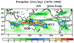
The Intertropical Convergence Zone, known by sailors as the doldrums or the calms because of its monotonous windless weather, is the area where the northeast and the southeast trade winds converge. It encircles Earth near the thermal equator though its specific position varies seasonally. When it lies near the geographic Equator, it is called the near-equatorial trough. Where the ITCZ is drawn into and merges with a monsoonal circulation, it is sometimes referred to as a monsoon trough.

In meteorology, a low-pressure area, low area or low is a region where the atmospheric pressure is lower than that of surrounding locations. Low-pressure areas are commonly associated with inclement weather, while high-pressure areas are associated with lighter winds and clear skies. Winds circle anti-clockwise around lows in the northern hemisphere, and clockwise in the southern hemisphere, due to opposing Coriolis forces. Low-pressure systems form under areas of wind divergence that occur in the upper levels of the atmosphere (aloft). The formation process of a low-pressure area is known as cyclogenesis. In meteorology, atmospheric divergence aloft occurs in two kinds of places:

The trade winds or easterlies are permanent east-to-west prevailing winds that flow in the Earth's equatorial region. The trade winds blow mainly from the northeast in the Northern Hemisphere and from the southeast in the Southern Hemisphere, strengthening during the winter and when the Arctic oscillation is in its warm phase. Trade winds have been used by captains of sailing ships to cross the world's oceans for centuries. They enabled European colonization of the Americas, and trade routes to become established across the Atlantic Ocean and the Pacific Ocean.

A pressure system is a peak or lull in the sea level pressure distribution. The surface pressure at sea level varies minimally, with the lowest value measured 87 kilopascals (26 inHg) and the highest recorded 108.57 kilopascals (32.06 inHg). High- and low-pressure systems evolve due to interactions of temperature differentials in the atmosphere, temperature differences between the atmosphere and water within oceans and lakes, the influence of upper-level disturbances, as well as the amount of solar heating or radiationized cooling an area receives. Pressure systems cause weather to be experienced locally. Low-pressure systems are associated with clouds and precipitation that minimize temperature changes throughout the day, whereas high-pressure systems normally associate with dry weather and mostly clear skies with larger diurnal temperature changes due to greater radiation at night and greater sunshine during the day. Pressure systems are analyzed by those in the field of meteorology within surface weather maps.
The South Pacific Convergence Zone (SPCZ), a reverse-oriented monsoon trough, is a band of low-level convergence, cloudiness and precipitation extending from the Western Pacific Warm Pool at the maritime continent south-eastwards towards French Polynesia and as far as the Cook Islands. The SPCZ is a portion of the Intertropical Convergence Zone (ITCZ) which lies in a band extending east–west near the Equator but can be more extratropical in nature, especially east of the International Date Line. It is considered the largest and most important piece of the ITCZ, and has the least dependence upon heating from a nearby landmass during the summer than any other portion of the monsoon trough. The SPCZ can affect the precipitation on Polynesian islands in the southwest Pacific Ocean, so it is important to understand how the SPCZ behaves with large-scale, global climate phenomenon, such as the ITCZ, El Niño–Southern Oscillation, and the Interdecadal Pacific oscillation (IPO), a portion of the Pacific decadal oscillation.
This is a list of meteorology topics. The terms relate to meteorology, the interdisciplinary scientific study of the atmosphere that focuses on weather processes and forecasting.

A mesoscale convective system (MCS) is a complex of thunderstorms that becomes organized on a scale larger than the individual thunderstorms but smaller than extratropical cyclones, and normally persists for several hours or more. A mesoscale convective system's overall cloud and precipitation pattern may be round or linear in shape, and include weather systems such as tropical cyclones, squall lines, lake-effect snow events, polar lows, and mesoscale convective complexes (MCCs), and generally forms near weather fronts. The type that forms during the warm season over land has been noted across North and South America, Europe, and Asia, with a maximum in activity noted during the late afternoon and evening hours.

The geography of South America contains many diverse regions and climates. Geographically, South America is generally considered a continent forming the southern portion of the landmass of the Americas, south and east of the Colombia–Panama border by most authorities, or south and east of the Panama Canal by some. South and North America are sometimes considered a single continent or supercontinent, while constituent regions are infrequently considered subcontinents.
The Hadley cell, also known as the Hadley circulation, is a global-scale tropical atmospheric circulation that features air rising near the equator, flowing poleward near the tropopause at a height of 12–15 km (7.5–9.3 mi) above the Earth's surface, cooling and descending in the subtropics at around 25 degrees latitude, and then returning equatorward near the surface. It is a thermally direct circulation within the troposphere that emerges due to differences in insolation and heating between the tropics and the subtropics. On a yearly average, the circulation is characterized by a circulation cell on each side of the equator. The Southern Hemisphere Hadley cell is slightly stronger on average than its northern counterpart, extending slightly beyond the equator into the Northern Hemisphere. During the summer and winter months, the Hadley circulation is dominated by a single, cross-equatorial cell with air rising in the summer hemisphere and sinking in the winter hemisphere. Analogous circulations may occur in extraterrestrial atmospheres, such as on Venus and Mars.

The monsoon trough is a portion of the Intertropical Convergence Zone in the Western Pacific, as depicted by a line on a weather map showing the locations of minimum sea level pressure, and as such, is a convergence zone between the wind patterns of the southern and northern hemispheres.

Tropical cyclogenesis is the development and strengthening of a tropical cyclone in the atmosphere. The mechanisms through which tropical cyclogenesis occurs are distinctly different from those through which temperate cyclogenesis occurs. Tropical cyclogenesis involves the development of a warm-core cyclone, due to significant convection in a favorable atmospheric environment.

A tropical rainforest climate or equatorial climate is a tropical climate sub-type usually found within 10 to 15 degrees latitude of the equator. There are some other areas at higher latitudes, such as the coast of southeast Florida, United States, and Okinawa, Japan that fall into the tropical rainforest climate category. They experience high mean annual temperatures, small temperature ranges, and rain that falls throughout the year. Regions with this climate are typically designated Af by the Köppen climate classification. A tropical rainforest climate is typically hot, very humid, and wet with no dry season.

A cold front is the leading edge of a cooler mass of air at ground level that replaces a warmer mass of air and lies within a pronounced surface trough of low pressure. It often forms behind an extratropical cyclone, at the leading edge of its cold air advection pattern—known as the cyclone's dry "conveyor belt" flow. Temperature differences across the boundary can exceed 30 °C (54 °F) from one side to the other. When enough moisture is present, rain can occur along the boundary. If there is significant instability along the boundary, a narrow line of thunderstorms can form along the frontal zone. If instability is weak, a broad shield of rain can move in behind the front, and evaporative cooling of the rain can increase the temperature difference across the front. Cold fronts are stronger in the fall and spring transition seasons and are weakest during the summer.

The Monsoon of South Asia is among several geographically distributed global monsoons. It affects the Indian subcontinent, where it is one of the oldest and most anticipated weather phenomena and an economically important pattern every year from June through September, but it is only partly understood and notoriously difficult to predict. Several theories have been proposed to explain the origin, process, strength, variability, distribution, and general vagaries of the monsoon, but understanding and predictability are still evolving.
There are a number of explanations of the asymmetry of the Intertropical Convergence Zone (ITCZ), known by sailors as the Doldrums.
The Tropical Atlantic Variability (TAV) is influenced by internal interaction and external effects. TAV can be discussed in different time scales: seasonal and interannual. tav can be discussed in different time scales:seasonal and interannual.and external effects.