Related Research Articles

El Niño–Southern Oscillation (ENSO) is a climate phenomenon that exhibits irregular quasi-periodic variation in winds and sea surface temperatures over the tropical Pacific Ocean. It affects the climate of much of the tropics and subtropics, and has links (teleconnections) to higher latitude regions of the world. The warming phase of the sea surface temperature is known as El Niño and the cooling phase as La Niña. The Southern Oscillation is the accompanying atmospheric component, which is coupled with the sea temperature change. El Niño is associated with higher than normal air sea level pressure over Indonesia, Australia and across the Indian Ocean to the Atlantic. La Niña has roughly the reverse pattern: high pressure over the central and eastern Pacific and lower pressure through much of the rest of the tropics and subtropics. The two phenomena last a year or so each and typically occur every two to seven years with varying intensity, with neutral periods of lower intensity interspersed. El Niño events can be more intense but La Niña events may repeat and last longer.
The North Atlantic Oscillation (NAO) is a weather phenomenon over the North Atlantic Ocean of fluctuations in the difference of atmospheric pressure at sea level (SLP) between the Icelandic Low and the Azores High. Through fluctuations in the strength of the Icelandic Low and the Azores High, it controls the strength and direction of westerly winds and location of storm tracks across the North Atlantic.

The Intertropical Convergence Zone, known by sailors as the doldrums or the calms because of its monotonous windless weather, is the area where the northeast and the southeast trade winds converge. It encircles Earth near the thermal equator though its specific position varies seasonally. When it lies near the geographic Equator, it is called the near-equatorial trough. Where the ITCZ is drawn into and merges with a monsoonal circulation, it is sometimes referred to as a monsoon trough.

The Pacific decadal oscillation (PDO) is a robust, recurring pattern of ocean-atmosphere climate variability centered over the mid-latitude Pacific basin. The PDO is detected as warm or cool surface waters in the Pacific Ocean, north of 20°N. Over the past century, the amplitude of this climate pattern has varied irregularly at interannual-to-interdecadal time scales. There is evidence of reversals in the prevailing polarity of the oscillation occurring around 1925, 1947, and 1977; the last two reversals corresponded with dramatic shifts in salmon production regimes in the North Pacific Ocean. This climate pattern also affects coastal sea and continental surface air temperatures from Alaska to California.

The Madden–Julian oscillation (MJO) is the largest element of the intraseasonal variability in the tropical atmosphere. It was discovered in 1971 by Roland Madden and Paul Julian of the American National Center for Atmospheric Research (NCAR). It is a large-scale coupling between atmospheric circulation and tropical deep atmospheric convection. Unlike a standing pattern like the El Niño–Southern Oscillation (ENSO), the Madden–Julian oscillation is a traveling pattern that propagates eastward, at approximately 4 to 8 m/s, through the atmosphere above the warm parts of the Indian and Pacific oceans. This overall circulation pattern manifests itself most clearly as anomalous rainfall.

The geography of South America contains many diverse regions and climates. Geographically, South America is generally considered a continent forming the southern portion of the landmass of the Americas, south and east of the Colombia–Panama border by most authorities, or south and east of the Panama Canal by some. South and North America are sometimes considered a single continent or supercontinent, while constituent regions are infrequently considered subcontinents.

Tropical cyclogenesis is the development and strengthening of a tropical cyclone in the atmosphere. The mechanisms through which tropical cyclogenesis occurs are distinctly different from those through which temperate cyclogenesis occurs. Tropical cyclogenesis involves the development of a warm-core cyclone, due to significant convection in a favorable atmospheric environment.
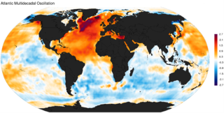
The Atlantic Multidecadal Oscillation (AMO), also known as Atlantic Multidecadal Variability (AMV), is the theorized variability of the sea surface temperature (SST) of the North Atlantic Ocean on the timescale of several decades.

The Indian Ocean Dipole (IOD), also known as the Indian Niño, is an irregular oscillation of sea surface temperatures in which the western Indian Ocean becomes alternately warmer and then colder than the eastern part of the ocean.
The Intergovernmental Panel on Climate Change (IPCC) with the United Nations Framework Convention on Climate Change (UNFCCC) use tens of acronyms and initialisms in documents relating to climate change policy.

The Monsoon of South Asia is among several geographically distributed global monsoons. It affects the Indian subcontinent, where it is one of the oldest and most anticipated weather phenomena and an economically important pattern every year from June through September, but it is only partly understood and notoriously difficult to predict. Several theories have been proposed to explain the origin, process, strength, variability, distribution, and general vagaries of the monsoon, but understanding and predictability are still evolving.
The Atlantic Equatorial Mode or Atlantic Niño is a quasiperiodic interannual climate pattern of the equatorial Atlantic Ocean. It is the dominant mode of year-to-year variability that results in alternating warming and cooling episodes of sea surface temperatures accompanied by changes in atmospheric circulation. The term Atlantic Niño comes from its close similarity with the El Niño-Southern Oscillation (ENSO) that dominates the tropical Pacific basin. For this reason, the Atlantic Niño is often called the little brother of El Niño. The Atlantic Niño usually appears in northern summer, and is not the same as the Atlantic Meridional (Interhemispheric) Mode that consists of a north-south dipole across the equator and operates more during northern spring. The equatorial warming and cooling events associated with the Atlantic Niño are known to be strongly related to rainfall variability over the surrounding continents, especially in West African countries bordering the Gulf of Guinea. Therefore, understanding of the Atlantic Niño has important implications for climate prediction in those regions. Although the Atlantic Niño is an intrinsic mode to the equatorial Atlantic, there may be a tenuous causal relationship between ENSO and the Atlantic Niño in some circumstances.
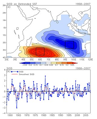
The Subtropical Indian Ocean Dipole (SIOD) is featured by the oscillation of sea surface temperatures (SST) in which the southwest Indian Ocean i.e. south of Madagascar is warmer and then colder than the eastern part i.e. off Australia. It was first identified in the studies of the relationship between the SST anomaly and the south-central Africa rainfall anomaly; the existence of such a dipole was identified from both observational studies and model simulations .
The Tropical Atlantic SST Dipole refers to a cross-equatorial sea surface temperature (SST) pattern that appears dominant on decadal timescales. It has a period of about 12 years, with the SST anomalies manifesting their most pronounced features around 10–15 degrees of latitude off of the Equator. It is also referred to as the interhemispheric SST gradient or the Meridional Atlantic mode.
The Tropical Atlantic Variability (TAV) is influenced by internal interaction and external effects. TAV can be discussed in different time scales: seasonal and interannual. tav can be discussed in different time scales:seasonal and interannual.and external effects.

The Tuvalu Meteorological Service (TMS) is the principal meteorological observatory of Tuvalu and is responsible for providing weather services to the islands of Tuvalu. A meteorological office was established on Funafuti at the time the islands of Tuvalu were administered as parts of the Gilbert and Ellice Islands colony of the United Kingdom. The meteorological office is now an agency of the government of Tuvalu.
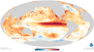
The 2014–2016 El Niño was a warming of the eastern equatorial Pacific Ocean that resulted in unusually warm waters developing between the coast of South America and the International Date Line. These unusually warm waters influenced the world's weather in a number of ways, which in turn significantly affected various parts of the world. These included drought conditions in Venezuela, Australia and a number of Pacific islands while significant flooding was also recorded. During the event, more tropical cyclones than normal occurred within the Pacific Ocean, while fewer than normal occurred in the Atlantic Ocean.

Pacific Meridional Mode (PMM) is a climate mode in the North Pacific. In its positive state, it is characterized by the coupling of weaker trade winds in the northeast Pacific Ocean between Hawaii and Baja California with decreased evaporation over the ocean, thus increasing sea surface temperatures (SST); and the reverse during its negative state. This coupling develops during the winter months and spreads southwestward towards the equator and the central and western Pacific during spring, until it reaches the Intertropical Convergence Zone (ITCZ), which tends to shift north in response to a positive PMM.
Ocean dynamical thermostat is a physical mechanism through which changes in the mean radiative forcing influence the gradients of sea surface temperatures in the Pacific Ocean and the strength of the Walker circulation. Increased radiative forcing (warming) is more effective in the western Pacific than in the eastern where the upwelling of cold water masses damps the temperature change. This increases the east-west temperature gradient and strengthens the Walker circulation. Decreased radiative forcing (cooling) has the opposite effect.

Effects of the El Niño–Southern Oscillation in Australia are present across most of Australia, particularly the north and the east, and are one of the main climate drivers of the country. Associated with seasonal abnormality in many areas in the world, Australia is one of the continents most affected and experiences extensive droughts alongside considerable wet periods that cause major floods. There exist three phases — El Niño, La Niña, and Neutral, which help to account for the different states of ENSO. Since 1900, there have been 28 El Niño and 19 La Niña events in Australia including the current 2023 El Niño event, which was declared on 17th of September in 2023. The events usually last for 9 to 12 months, but some can persist for two years, though the ENSO cycle generally operates over a time period from one to eight years.
References
World Wide Web
- ↑ E. Linacre and B. Geerts. Movement of the South Pacific Convergence Zone. Retrieved on 2006-11-26.
- ↑ Glossary of Meteorology. South Pacific convergence zone. Archived 2007-09-30 at the Wayback Machine Retrieved on 2006-11-26.
- ↑ Cocks, Stephen Brenton (2003). An observational study of the South Pacific Convergence Zone using satellite and model re-analysis data (PhD dissertation). Texas A&M University. hdl:1969.1/374.
- 1 2 3 4 5 C. K. Folland, J. A. Renwick, M. J. Salinger, A. B. Mullan (2002). "Relative influences of the Interdecadal Pacific Oscillation and ENSO in the South Pacific Convergence Zone". Geophysical Research Letters. 29 (13): 21–1–21–4. Bibcode:2002GeoRL..29.1643F. doi: 10.1029/2001GL014201 .
{{cite journal}}: CS1 maint: multiple names: authors list (link) - 1 2 3 Braddock K. Linsley, Alexey Kaplan, Yves Gouriou, Jim Salinger, Peter B. deMenocal, Gerard M. Wellington, and Stephen S. Howe. Tracking the extent of the South Pacific Convergence Zone since the early 1600s. Archived 2011-06-06 at the Wayback Machine Retrieved on 2006-11-26.
- 1 2 Matthew J. Widlansky, Axel Timmermann, Karl Stein, Shayne McGregor, Niklas Schneider, Matthew H. England, Matthieu Lengaigne, and Wenju Cai. Changes in South Pacific rainfall bands in a warming climate
- (in French)
Tropical textbook : from trade winds to cyclone (2 vol) Archived 2012-12-16 at archive.today , 897 pp., Florent Beucher, 25 mai 2010, Météo-France, ISBN 978-2-11-099391-5
- C. K. Folland, J. A. Renwick, M. J. Salinger, A. B. Mullan (2002). "Relative influences of the Interdecadal Pacific Oscillation and ENSO in the South Pacific Convergence Zone". Geophysical Research Letters. 29 (13): 21–1–21–4. Bibcode:2002GeoRL..29.1643F. doi: 10.1029/2001GL014201 .
{{cite journal}}: CS1 maint: multiple names: authors list (link)