The Sāmoan archipelago is a chain of 16 islands and numerous seamounts covering 3,123 km2 (1,206 sq mi) in the central South Pacific, south of the equator, about halfway between Hawaii and New Zealand, forming part of Polynesia and of the wider region of Oceania. The islands are Savaiʻi, Upolu, Tutuila, ’Uvea, Taʻū, Ofu, Olosega, Apolima, Manono, Nuʻutele, Niulakita, Nuʻulua, Namua, Fanuatapu, Rose Atoll, Nu'ulopa, as well as the submerged Vailuluʻu, Pasco banks, and Alexa Bank.

In marine geology, a guyot, also known as a tablemount, is an isolated underwater volcanic mountain (seamount) with a flat top more than 200 m (660 ft) below the surface of the sea. The diameters of these flat summits can exceed 10 km (6.2 mi). Guyots are most commonly found in the Pacific Ocean, but they have been identified in all the oceans except the Arctic Ocean.

In geology, hotspots are volcanic locales thought to be fed by underlying mantle that is anomalously hot compared with the surrounding mantle. Examples include the Hawaii, Iceland, and Yellowstone hotspots. A hotspot's position on the Earth's surface is independent of tectonic plate boundaries, and so hotspots may create a chain of volcanoes as the plates move above them.

A large igneous province (LIP) is an extremely large accumulation of igneous rocks, including intrusive and extrusive, arising when magma travels through the crust towards the surface. The formation of LIPs is variously attributed to mantle plumes or to processes associated with divergent plate tectonics. The formation of some of the LIPs in the past 500 million years coincide in time with mass extinctions and rapid climatic changes, which has led to numerous hypotheses about causal relationships. LIPs are fundamentally different from any other currently active volcanoes or volcanic systems.

Volcanic activity is a major part of the geology of Canada and is characterized by many types of volcanic landform, including lava flows, volcanic plateaus, lava domes, cinder cones, stratovolcanoes, shield volcanoes, submarine volcanoes, calderas, diatremes, and maars, along with less common volcanic forms such as tuyas and subglacial mounds.

Meiji Seamount, named after Emperor Meiji, the 122nd Emperor of Japan, is the oldest seamount in the Hawaiian-Emperor seamount chain, with an estimated age of 82 million years. It lies at the northernmost end of the chain, and is perched at the outer slope of the Kuril–Kamchatka Trench. Like the rest of the Emperor seamounts, it was formed by the Hawaii hotspot volcanism, grew to become an island, and has since subsided to below sea level, all while being carried first north and now northwest by the motion of the Pacific Plate. Meiji Seamount is thus an example of a particular type of seamount known as a guyot, and some publications refer to it as Meiji Guyot.

The New England hotspot, also referred to as the Great Meteor hotspot and sometimes the Monteregian hotspot, is a volcanic hotspot in the North Atlantic Ocean. It created the Monteregian Hills intrusions in Montreal and Montérégie, the White Mountains intrusions in New Hampshire, the New England and Corner Rise seamounts off the coast of North America, and the Seewarte Seamounts east of the Mid-Atlantic Ridge on the African Plate, the latter of which include its most recent eruptive center, the Great Meteor Seamount. The New England, Great Meteor, or Monteregian hotspot track has been used to estimate the movement of the North American Plate away from the African Plate from the early Cretaceous period to the present using the fixed hotspot reference frame.

The Hawai’i hotspot is a volcanic hotspot located near the namesake Hawaiian Islands, in the northern Pacific Ocean. One of the best known and intensively studied hotspots in the world, the Hawaii plume is responsible for the creation of the Hawaiian–Emperor seamount chain, a 6,200-kilometer (3,900 mi) mostly undersea volcanic mountain range. Four of these volcanoes are active, two are dormant; more than 123 are extinct, most now preserved as atolls or seamounts. The chain extends from south of the island of Hawaiʻi to the edge of the Aleutian Trench, near the eastern coast of Russia.

The Marquesas hotspot is a volcanic hotspot in the southern Pacific Ocean. It is responsible for the creation of the Marquesas Islands – a group of eight main islands and several smaller ones – and a few seamounts. The islands and seamounts formed between 5.5 and 0.4 million years ago and constitute the northernmost volcanic chain in French Polynesia.

The Fundy Basin is a sediment-filled rift basin on the Atlantic coast of southeastern Canada. It contains three sub-basins; the Fundy sub-basin, the Minas Basin and the Chignecto Basin. These arms meet at the Bay of Fundy, which is contained within the rift valley. From the Bay of Fundy, the Minas Basin trends northeast to Nova Scotia. Chignecto Bay runs from the Bay of Fundy northwest between New Brunswick and Nova Scotia which is separated from the waters of the Northumberland Strait by the Isthmus of Chignecto. The Fundy Basin is best known for the bay it contains. The Bay of Fundy is home to huge tidal changes and tidal bores. It is part of the system of Eastern North America Rift Basins.
The Fogo Seamounts, also called the Fogo Seamount Chain, are a group of undersea mountains southeast of the Grand Banks of Newfoundland in the North Atlantic Ocean. This seamount chain, lying approximately 500 km (310 mi) offshore from the island of Newfoundland, consists of several submarine volcanoes that have been extinct for millions of years. They are one of the few seamount chains located in Canadian waters off the coast of Atlantic Canada.

The Mariana Plate is a micro tectonic plate located west of the Mariana Trench which forms the basement of the Mariana Islands which form part of the Izu–Bonin–Mariana Arc. It is separated from the Philippine Sea Plate to the west by a divergent boundary with numerous transform fault offsets. The boundary between the Mariana and the Pacific Plate to the east is a subduction zone with the Pacific Plate subducting beneath the Mariana. This eastern subduction is divided into the Mariana Trench, which forms the southeastern boundary, and the Izu–Ogasawara Trench the northeastern boundary. The subduction plate motion is responsible for the shape of the Mariana plate and back arc.
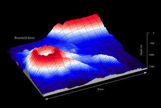
Orca Seamount is a seamount near King George Island in Antarctica, in the Bransfield Strait. While it is inactive, last volcanic activity at Orca Seamount is judged to have occurred in the recent past as there are temperature anomalies in the seawater around at the seamount. Thermophilic and hyperthermophilic microorganisms organism have been found at the seamount.
The Newfoundland Ridge is an ocean ridge in the northern Atlantic Ocean, located on the east coast of Canada. It was the site for major volcanic activity in the Barremian–Aptian period.

The volcanology of Eastern Canada includes the hundreds of volcanic areas and extensive lava formations in Eastern Canada. The region's different volcano and lava types originate from different tectonic settings and types of volcanic eruptions, ranging from passive lava eruptions to violent explosive eruptions. Eastern Canada has very large volumes of magmatic rock called large igneous provinces. They are represented by deep-level plumbing systems consisting of giant dike swarms, sill provinces and layered intrusions. The most capable large igneous provinces in Eastern Canada are Archean age greenstone belts containing a rare volcanic rock called komatiite.
The Macdonald hotspot is a volcanic hotspot in the southern Pacific Ocean. The hotspot was responsible for the formation of the Macdonald Seamount, and possibly the Austral-Cook Islands chain. It probably did not generate all of the volcanism in the Austral and Cook Islands as age data imply that several additional hotspots were needed to generate some volcanoes.

Ganis Chasma is a group of rift zones on the surface of the planet Venus. Bright spots detected by the Venus Monitoring Camera on the European Space Agency's Venus Express in the area suggest that there may be active volcanism on Venus.
The Tasmantid hotspot is a volcanic hotspot located in the South Pacific Ocean. Due to plate tectonics the hotspot was under different parts of the seabed in the past. It was initially centred under what is now the southern Coral Sea 60 million years ago where the first Tasmantid volcano was created. As the Indo-Australian Plate continued to drift northwards the hotspot was positioned in the northern Tasman Sea 20 million years ago, eventually reaching its current location east of Tasmania in response to ongoing northward plate motion.
Foundation Seamounts are a series of seamounts in the southern Pacific Ocean. Discovered in 1992, these seamounts form a 1,350 kilometres (840 mi) long chain which starts from the Pacific-Antarctic Ridge. Some of these seamounts may have once emerged from the ocean.
Alexa Bank is a seamount in Samoa, northwest of Rotuma. The seamount reaches a depth of 18–21 metres (59–69 ft) below sea level and has the appearance of an atoll with a flat top and steep slopes. Some active coral growth takes place at its top, but if it ever was an active atoll it has now drowned. It was probably formed by the Samoa hotspot 24 million years ago, although older volcanism about 40 million years ago has also been identified.