
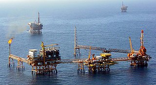
In offshore and coastal engineering, metocean refers to the syllabic abbreviation of meteorology and (physical) oceanography.
In offshore and coastal engineering, metocean refers to the syllabic abbreviation of meteorology and (physical) oceanography.
In various stages of an offshore or coastal engineering project a metocean study will be undertaken. This, in order to estimate the environmental conditions of direct influence on the choices to be made during the project phase at hand, and to arrive at an effective and efficient solution for the problems/goals stated. In later phases of a project, more detailed and thorough metocean studies may be needed, depending on whether there is an expected additional gain with respect to the successful and efficient completion of the project.
Metocean conditions refer to the combined wind, wave and climate (etc.) conditions as found on a certain location. They are most often presented as statistics, including seasonal variations, scatter tables, wind roses and probability of exceedance. The metocean conditions may include, depending on the project and its location, statistics on:

The metocean conditions are preferably based on metocean data, which can come from measuring instruments deployed in or near the project area, global (re-analysis) models and remote sensing (often by satellites). For estimating probabilities of exceedance – for relevant physical quantities – data of extreme events during more than one year is needed.
By use of validated numerical models, the availability of metocean data can be extended. For instance, consider the case of a coastal location where no wave measurements are available. If there is long-term wave data available in a nearby offshore location (e.g. from satellites), a wind wave model can be employed to transform the offshore wave statistics to the nearshore location (provided the bathymetry is known).
Often, long-term local measurements of wave conditions due to extreme events (e.g. hurricanes) are missing. By using estimates for the wind fields during past extreme events, the corresponding wave conditions can be computed through wave hindcasts. [2]
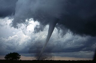
Extreme weather includes unexpected, unusual, severe, or unseasonal weather; weather at the extremes of the historical distribution—the range that has been seen in the past. Extreme events are based on a location's recorded weather history. They are defined as lying in the most unusual ten percent. The main types of extreme weather include heat waves, cold waves and heavy precipitation or storm events, such as tropical cyclones. The effects of extreme weather events are economic costs, loss of human lives, droughts, floods, landslides. Severe weather is a particular type of extreme weather which poses risks to life and property.

Upwelling is an oceanographic phenomenon that involves wind-driven motion of dense, cooler, and usually nutrient-rich water from deep water towards the ocean surface. It replaces the warmer and usually nutrient-depleted surface water. The nutrient-rich upwelled water stimulates the growth and reproduction of primary producers such as phytoplankton. The biomass of phytoplankton and the presence of cool water in those regions allow upwelling zones to be identified by cool sea surface temperatures (SST) and high concentrations of chlorophyll a.

In meteorology, wind speed, or wind flow speed, is a fundamental atmospheric quantity caused by air moving from high to low pressure, usually due to changes in temperature. Wind speed is now commonly measured with an anemometer.
The National Weather Service (NWS) is an agency of the United States federal government that is tasked with providing weather forecasts, warnings of hazardous weather, and other weather-related products to organizations and the public for the purposes of protection, safety, and general information. It is a part of the National Oceanic and Atmospheric Administration (NOAA) branch of the Department of Commerce, and is headquartered in Silver Spring, Maryland, within the Washington metropolitan area. The agency was known as the United States Weather Bureau from 1890 until it adopted its current name in 1970.

Physical oceanography is the study of physical conditions and physical processes within the ocean, especially the motions and physical properties of ocean waters.

A storm surge, storm flood, tidal surge, or storm tide is a coastal flood or tsunami-like phenomenon of rising water commonly associated with low-pressure weather systems, such as cyclones. It is measured as the rise in water level above the normal tidal level, and does not include waves.

Rogue waves are unusually large, unpredictable, and suddenly appearing surface waves that can be extremely dangerous to ships and isolated structures such as lighthouses. They are distinct from tsunamis, which are often almost unnoticeable in deep waters and are caused by the displacement of water due to other phenomena. A rogue wave at the shore is sometimes called a sneaker wave.
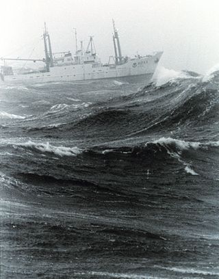
In oceanography, sea state is the general condition of the free surface on a large body of water—with respect to wind waves and swell—at a certain location and moment. A sea state is characterized by statistics, including the wave height, period, and spectrum. The sea state varies with time, as the wind and swell conditions change. The sea state can be assessed either by an experienced observer or by using instruments like weather buoys, wave radar or remote sensing satellites.
The Atlantic Oceanographic and Meteorological Laboratory (AOML), a federal research laboratory, is part of the National Oceanic and Atmospheric Administration's (NOAA) Office of Oceanic and Atmospheric Research (OAR), located in Miami in the United States. AOML's research spans tropical cyclone and hurricanes, coastal ecosystems, oceans and human health, climate studies, global carbon systems, and ocean observations. It is one of seven NOAA Research Laboratories (RLs).

Marine engineering is the engineering of boats, ships, submarines, and any other marine vessel. Here it is also taken to include the engineering of other ocean systems and structures – referred to in certain academic and professional circles as “ocean engineering.”

Weather buoys are instruments which collect weather and ocean data within the world's oceans, as well as aid during emergency response to chemical spills, legal proceedings, and engineering design. Moored buoys have been in use since 1951, while drifting buoys have been used since 1979. Moored buoys are connected with the ocean bottom using either chains, nylon, or buoyant polypropylene. With the decline of the weather ship, they have taken a more primary role in measuring conditions over the open seas since the 1970s. During the 1980s and 1990s, a network of buoys in the central and eastern tropical Pacific Ocean helped study the El Niño-Southern Oscillation. Moored weather buoys range from 1.5–12 metres (5–40 ft) in diameter, while drifting buoys are smaller, with diameters of 30–40 centimetres (12–16 in). Drifting buoys are the dominant form of weather buoy in sheer number, with 1250 located worldwide. Wind data from buoys has smaller error than that from ships. There are differences in the values of sea surface temperature measurements between the two platforms as well, relating to the depth of the measurement and whether or not the water is heated by the ship which measures the quantity.

Coastal engineering is a branch of civil engineering concerned with the specific demands posed by constructing at or near the coast, as well as the development of the coast itself.

The Ocean Prediction Center (OPC), established in 1995, is one of the National Centers for Environmental Prediction's (NCEP's) original six service centers. Until 2003, the name of the organization was the Marine Prediction Center. Its origins are traced back to the sinking of the RMS Titanic in 1912. The OPC issues forecasts up to five days in advance for ocean areas north of 31° north latitude and west of 35° west longitude in the Atlantic, and across the northeast Pacific north of 30° north latitude and east of 160° east longitude. Until recently, the OPC provided forecast points for tropical cyclones north of 20° north latitude and east of the 60° west longitude to the National Hurricane Center. OPC is composed of two branches: the Ocean Forecast Branch and the Ocean Applications Branch.
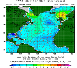
In fluid dynamics, wind wave modeling describes the effort to depict the sea state and predict the evolution of the energy of wind waves using numerical techniques. These simulations consider atmospheric wind forcing, nonlinear wave interactions, and frictional dissipation, and they output statistics describing wave heights, periods, and propagation directions for regional seas or global oceans. Such wave hindcasts and wave forecasts are extremely important for commercial interests on the high seas. For example, the shipping industry requires guidance for operational planning and tactical seakeeping purposes.
The following is a glossary of tropical cyclone terms.
Offshore geotechnical engineering is a sub-field of geotechnical engineering. It is concerned with foundation design, construction, maintenance and decommissioning for human-made structures in the sea. Oil platforms, artificial islands and submarine pipelines are examples of such structures. The seabed has to be able to withstand the weight of these structures and the applied loads. Geohazards must also be taken into account. The need for offshore developments stems from a gradual depletion of hydrocarbon reserves onshore or near the coastlines, as new fields are being developed at greater distances offshore and in deeper water, with a corresponding adaptation of the offshore site investigations. Today, there are more than 7,000 offshore platforms operating at a water depth up to and exceeding 2000 m. A typical field development extends over tens of square kilometers, and may comprise several fixed structures, infield flowlines with an export pipeline either to the shoreline or connected to a regional trunkline.
The DeepCwind Consortium was a national consortium of universities, nonprofits, utilities, and industry leaders. The mission of the consortium was to establish the State of Maine as a national leader in floating offshore wind technology. Much of the consortium's work and resulting research was funded by the U.S. Department of Energy, the National Science Foundations, and others.

Heceta Bank is a rocky bank located 55 kilometers (km) off the Oregon coast near Florence, centered on approximately 44°N, 125°W, and is roughly 29 km long and upwards of 13 km wide. Heceta Bank is an area of ecological and oceanographic importance. The unique bathymetric features and seasonal circulation within the bank provides habitat for a diversity of economically-important fish species.
The nonlinearity of surface gravity waves refers to their deviations from a sinusoidal shape. In the fields of physical oceanography and coastal engineering, the two categories of nonlinearity are skewness and asymmetry. Wave skewness and asymmetry occur when waves encounter an opposing current or a shallow area. As waves shoal in the nearshore zone, in addition to their wavelength and height changing, their asymmetry and skewness also change. Wave skewness and asymmetry are often implicated in ocean engineering and coastal engineering for the modelling of random sea states, in particular regarding the distribution of wave height, wavelength and crest length. For practical engineering purposes, it is important to know the probability of these wave characteristics in seas and oceans at a given place and time. This knowledge is crucial for the prediction of extreme waves, which are a danger for ships and offshore structures. Satellite altimeter Envisat RA-2 data shows geographically coherent skewness fields in the ocean and from the data has been concluded that large values of skewness occur primarily in regions of large significant wave height.
Basil Wrigley Wilson was an oceanographic engineer and researcher in the field of coastal engineering who made significant contributions to the study of ocean waves, ship motion, and mooring technology.