List of provincial bioregions
This is a list of IMCRA 4.0 provincial bioregions: [3]
| Bioregion | information | IMCRA meso-scale bioregions | Marine Ecoregions of the World designation |
|---|---|---|---|
| Bass Strait Shelf Province | cold temperate waters | Central Victoria (CV) Victoria Embayment (VE), Central Bass Strait (CBS), Boags (BGS) | Bassian (205) |
| Cape Province | na | na | |
| Central Eastern Shelf Province | warm temperate waters | Manning Shelf (MAN), Hawkesbury Shelf (HAW) | Manning-Hawkesbury (203) |
| Central Eastern Shelf Transition | transition between the tropical Northeast Shelf and warm-temperate Central Eastern Shelf provinces | Tweed-Moreton (TM) | Tweed-Moreton (202) |
| Central Eastern Province | na | na | |
| Central Eastern Transition | na | na | |
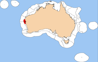
| Central Western Shelf Province | subtropical waters | Shark Bay (SBY), Zuytdorp (ZUY) | Shark Bay (210) |
| Central Western Shelf Transition | transition | Ningaloo (NIN) | Ningaloo (145) |
| Central Western Province | subtropical waters | na | na |
| Central Western Transition | na | na | |
| Christmas Island Province | tropical waters | Cocos-Keeling/Christmas Island (120) | |
| Cocos (Keeling) Island Province | tropical waters | Cocos-Keeling/Christmas Island (120) | |
| Great Australian Bight Shelf Transition | transition between the warm-temperate Southwest Shelf and Spencer Gulf Shelf provinces | Eucla (EUC), Murat (MUR) | Great Australian Bight (208) |
| Kenn Province | tropical waters | na | na |
| Kenn Transition | |||
| Lord Howe Province | warm temperate waters | Lord Howe and Norfolk Islands (151) | |
| Macquarie Island Province | cold temperate waters | Macquarie Island (212) | |
| Norfolk Island Province | warm temperate waters | Lord Howe and Norfolk Islands (151) | |
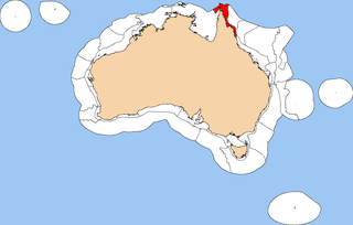
| Northeast Shelf Province | tropical waters | West Tropic Coast (WTC), Central Reef (CR), Lucinda-Mackay Coast (LMC), Shoalwater Coast (SC), Mackay-Capricorn (MC), Pompey-Swains (PS) | Central and Southern Great Barrier Reef (143) |
| Northeast Shelf Transition | transition between the tropical Northern Shelf and Northeast Shelf provinces | Torres Strait (TS), East Cape York (ECY), Ribbons (RBN) | Torres Strait and Northern Great Barrier Reef (142) |
| Northeast Province | tropical waters | na | na |
| Northeast Transition | na | na | |
| Northern Shelf Province | tropical waters | Van Diemens Gulf (VDG), Cobourg (COB), Arafura (ARA), Arnhem Wessel (AWS), Carpentaria (CAR), Groote (GRO), Pellew (PEL), Wellesley (WLY), Karumba-Nassau (KAN), West Cape York (WCY) | Arnhem Coast to Gulf of Carpentaria (140) |
| Northwest Province | tropical waters | na | na |
| Northwest Shelf Province | tropical waters | Pilbara (nearshore) (PIN), Pilbara (offshore) (PIO), Eighty Mile Beach (EMB), Canning (CAN), North West Shelf (NWS) | Exmouth to Broome (144) |
| Northwest Shelf Transition | transition between the tropical Northern Shelf and Northwest Shelf provinces | Kimberley (KIM), King Sound (KSD), Anson Beagle (ANB), Cambridge-Bonaparte (CAB), Bonaparte Gulf (BON), Tiwi (TWI) | Bonaparte Coast (141) |
| Northwest Transition | na | na | |
| Southeast Shelf Transition | transition between the warm-temperate Central Eastern Shelf and the cold-temperate Bass Strait Shelf provinces | Batemans Shelf (BAT), Flinders (FLI), Twofold Shelf (TWO) | Cape Howe (204) |
| Southeast Transition | na | na | |
| Southern Province | warm temperate waters | na | na |
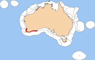
| Southwest Shelf Province | warm temperate waters | Leeuwin–Naturaliste (LNE), Western Australia South Coast (WSC) | Leeuwin (209) |
| Southwest Shelf Transition | transition between the subtropical Central West Province and the warm temperate Southwest Shelf Province | Abrolhos Islands (ABR) and Central West Coast (CWC) | Houtman (211) |
| Southwest Transition | na | na | |
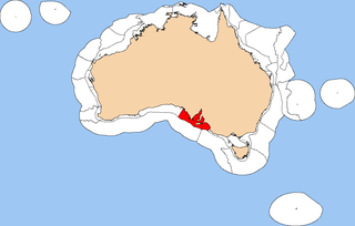
| Spencer Gulf Shelf Province | warm temperate waters | Coorong (COR), Eyre (EYR), North Spencer Gulf (NSG), St Vincent Gulf (SVG), Spencer Gulf (SG) | South Australian Gulfs (207) |
| Tasmania Province | cold temperate waters | na | na |
| Tasmanian Shelf Province | cold temperate waters | Bruny (BRU), Davey (DAV), Franklin (FRA), Freycinet (FRT) | Bassian (205) |
| Timor Province | tropical waters | na | na |
| Timor Transition | na | na | |
| West Tasmania Transition | na | na | |
| Western Bass Strait Shelf Transition | transition between the cold-temperate Bass Strait Shelf and Tasmanian Shelf provinces and the warm-temperate Spencer Gulf Shelf Province | Otway (OTW) | Western Bassian (206) |