
The Great Australian Bight is a large oceanic bight, or open bay, off the central and western portions of the southern coastline of mainland Australia.
The Integrated Marine and Coastal Regionalisation of Australia (IMCRA), formerly the Interim Marine and Coastal Regionalisation for Australia, is a biogeographic regionalisation of the oceanic waters of Australia's exclusive economic zone (EEZ). As of 2008, the most recent version is IMCRA Version 4.0.

The Bass Strait Shelf Province is a biogeographic region of Australia's coastal and continental shelf waters. It covers the central Bass Strait between Tasmania and the southern Australian mainland. It is a provincial level bioregion in the Integrated Marine and Coastal Regionalisation of Australia (IMCRA) system. The Bassian and adjacent Tasmanian Shelf provinces correspond to the Bassian marine ecoregion in the WWF's Marine Ecoregions of the World system.

The Central Eastern Shelf Province is a biogeographic region of Australia's coastal and continental shelf waters. It includes the warm temperate coastal waters of eastern Australia. It is a provincial level bioregion in the Integrated Marine and Coastal Regionalisation of Australia (IMCRA) system. It corresponds to the Manning-Hawkesbury marine ecoregion in the WWF's Marine Ecoregions of the World system.

Tweed–Moreton, also known as the Central Eastern Shelf Transition, is a marine biogeographic region of eastern Australia.
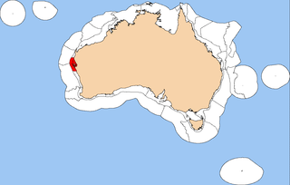
The Central Western Shelf Province, also known as the Shark Bay marine ecoregion, is a biogeographic region of Australia's continental shelf and coastal waters. It includes the subtropical coastal waters of Western Australia.

The Northeast Shelf Province is a biogeographic region of Australia's coastal and continental shelf waters. It includes the tropical coastal waters of the central and southern Great Barrier Reef in northeastern Australia. It is a provincial level bioregion in the Integrated Marine and Coastal Regionalisation of Australia (IMCRA) system. It corresponds to the Central and Southern Great Barrier Reef marine ecoregion in the WWF's Marine Ecoregions of the World system.
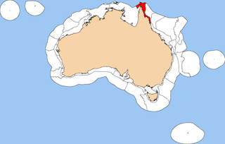
The Northeast Shelf Transition is a biogeographic region of Australia's coastal and continental shelf waters. It includes the tropical coastal waters of the northern Great Barrier Reef and the Torres Strait in northeastern-most Australia. It is a provincial level bioregion in the Integrated Marine and Coastal Regionalisation of Australia (IMCRA) system. It corresponds to the Torres Strait and Northern Great Barrier Reef marine ecoregion in the WWF's Marine Ecoregions of the World system.

The Northern Shelf Province, also known as Arnhem Coast to Gulf of Carpentaria, is a biogeographic region of Australia's continental shelf. It includes the coastal waters of Arnhem Land and the Gulf of Carpentaria in Northern Australia.

The Northwest Shelf Province, also known as Exmouth to Broome, is a biogeographic region of Australia's continental shelf.

The Northwest Shelf Transition, also known as Bonaparte Coast, is a biogeographic region of Australia's continental shelf. It adjoins the Kimberley region of Western Australia and the adjacent coast of the Northern Territory.

The Southeast Shelf Transition is a biogeographic region of Australia's coastal and continental shelf waters. It covers a portion of Australia's southeastern coast, from southern New South Wales to eastern Victoria, including the islands of the Kent Group and Furneaux Group at the eastern end of the Bass Strait. It is a provincial level bioregion in the Integrated Marine and Coastal Regionalisation of Australia (IMCRA) system, and is a transitional region between the warm temperate Central Eastern Shelf Province to the northwest and the cool temperate Bass Strait Shelf and Tasmanian Shelf provinces to the west and south. It corresponds to the Cape Howe marine ecoregion in the WWF's Marine Ecoregions of the World system.
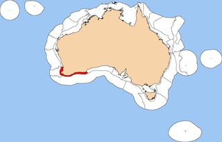
The Southwest Shelf Province, also known as the Leeuwin marine ecoregion, is a biogeographic region of Australia's continental shelf. It includes the temperate coastal waters of Southwest Australia.

The Southwest Shelf Transition, also known as the Houtman marine ecoregion, is a biogeographic region of Australia's continental shelf and coastal waters. It includes the subtropical coastal waters of Southwest Australia.

The Western Bass Strait Shelf Transition is a biogeographic region of Australia's coastal and continental shelf waters. It is a transitional region between the cold-temperate Bass Strait Shelf and Tasmanian Shelf provinces and the warm-temperate Spencer Gulf Shelf Province. It corresponds with the southern portion of the Western Bassian marine ecoregion,

The South-west Corner Marine Park is a marine protected area on the lower south west and southern coast of Western Australia, one of 14 in the South-west Marine Parks Network.
In South Australia, one of the states of Australia, there are many areas which are commonly known by regional names. Regions are areas that share similar characteristics. These characteristics may be natural such as the Murray River, the coastline, desert or mountains. Alternatively, the characteristics may be cultural, such as common land use. South Australia is divided by numerous sets of regional boundaries, based on different characteristics. In many cases boundaries defined by different agencies are coterminous.

Western Kangaroo Island Marine Park is a marine protected area located south of South Australia in waters within the Australian Exclusive economic zone to the south-west of Kangaroo Island and ranging in depth from 15 metres to 165 metres.
Southern Kangaroo Island Marine Park is a marine protected area located south of South Australia in waters within the Australian Exclusive economic zone to the south of Kangaroo Island and ranging in depth from 15 metres to 100 metres.
