
The Southwest Shelf Province, also known as the Leeuwin marine ecoregion, [1] is a biogeographic region of Australia's continental shelf. It includes the temperate coastal waters of Southwest Australia.
The Southwest Shelf Province, also known as the Leeuwin marine ecoregion, [1] is a biogeographic region of Australia's continental shelf. It includes the temperate coastal waters of Southwest Australia.
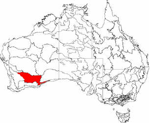
The Southwest Shelf Province includes the coastal waters and continental shelf of south west Western Australia, extending from the vicinity of Perth on the west coast to Israelite Bay on the south coast.
The continental shelf is generally narrow, with some small offshore islets, including the Recherche Archipelago. The coastline is affected by heavy, high-energy swells. Rocky headlands of granitic, doleritic, or gneissic rock are found along much of the coast, interspersed with curving bays and sandy beaches. Seagrass meadows are found in sheltered bays and inlets. [2]
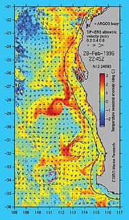
The warm Leeuwin Current runs southwards along the west coast, and turns eastwards to follow the south coast. A colder inshore counter-current runs northwards along the west coast.
The Southwest Shelf Transition, or Houtman marine bioregion, lies to the north. The Great Australian Bight lies to the east. [3]
The Integrated Marine and Coastal Regionalisation for Australia (IMCRA) identifies two meso-scale bioregions that make up the province. [2]

The Carnarvon xeric shrublands is a deserts and xeric shrublands ecoregion of Western Australia. The ecoregion is coterminous with the Carnarvon Interim Biogeographic Regionalisation for Australia (IBRA) bioregion.
The Leeuwin Current is a warm ocean current which flows southwards near the western coast of Australia. It rounds Cape Leeuwin to enter the waters south of Australia where its influence extends as far as Tasmania.

Warren, also known as Karri Forest Region and the Jarrah-Karri forest and shrublands ecoregion, is a biogeographic region in southern Western Australia. Located in the southwest corner of Western Australia between Cape Naturaliste and Albany, it is bordered to the north and east by the Jarrah Forest region. Its defining characteristic is an extensive tall forest of Eucalyptus diversicolor (karri). This occurs on dissected, hilly ground, with a moderately wet climate. Karri is a valuable timber and much of the karri forest has been logged over, but less than a third has been cleared for agriculture. Recognised as a region under the Interim Biogeographic Regionalisation for Australia (IBRA), and as a terrestrial ecoregion by the World Wide Fund for Nature, it was first defined by Ludwig Diels in 1906.
Coolgardie is an Australian bioregion consisting of an area of low hills and plains of infertile sandy soil in Western Australia. It has an area of 129,122.09 square kilometres (49,854.32 sq mi). It includes much of the Great Western Woodlands.

Yalgoo is an interim Australia bioregion located in Western Australia. It has an area of 5,087,577 hectares. The bioregion, together with the Avon Wheatbelt and Geraldton Sandplains bioregions, is part of the larger Southwest Australia savanna ecoregion as classified by the World Wildlife Fund.
The Integrated Marine and Coastal Regionalisation of Australia (IMCRA), formerly the Interim Marine and Coastal Regionalisation for Australia, is a biogeographic regionalisation of the oceanic waters of Australia's exclusive economic zone (EEZ). As of 2008, the most recent version is IMCRA Version 4.0.

Tweed–Moreton, also known as the Central Eastern Shelf Transition, is a marine biogeographic region of eastern Australia.
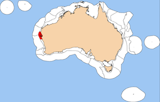
The Central Western Shelf Province, also known as the Shark Bay marine ecoregion, is a biogeographic region of Australia's continental shelf and coastal waters. It includes the subtropical coastal waters of Western Australia.

The Northern Shelf Province, also known as Arnhem Coast to Gulf of Carpentaria, is a biogeographic region of Australia's continental shelf. It includes the coastal waters of Arnhem Land and the Gulf of Carpentaria in Northern Australia.

The Northwest Shelf Province, also known as Exmouth to Broome, is a biogeographic region of Australia's continental shelf.

The Northwest Shelf Transition, also known as Bonaparte Coast, is a biogeographic region of Australia's continental shelf. It adjoins the Kimberley region of Western Australia and the adjacent coast of the Northern Territory.

The Southwest Shelf Transition, also known as the Houtman marine ecoregion, is a biogeographic region of Australia's continental shelf and coastal waters. It includes the subtropical coastal waters of Southwest Australia.
Western Australia has the longest coastline of any state or territory in Australia, at 10,194 km or 12,889 km. It is a significant portion of the coastline of Australia, which is 35,877 km.
The south coast of Western Australia comprises the Western Australian coastline from Cape Leeuwin to Eucla. This is a distance of approximately 1,600 kilometres (1,000 mi), fronting the Great Australian Bight and the Southern Ocean.

The Jurien Bay Marine Park is a protected marine park that is located 200 to 300 kilometres north of Perth, off the coastal tip of the Wheatbelt region of Western Australia. The 82,375-hectare (203,550-acre) marine park was formally declared on 31 August 2003 and is situated along the Indian Ocean Drive that extends south from Green Head to the southern boundary of Nambung National Park. It includes many of the islands located in this region.

The South-west Corner Marine Park is a marine protected area on the lower south west and southern coast of Western Australia, one of 14 in the South-west Marine Parks Network.

The Pilbara Coast is the coastline of Western Australia's Pilbara region. It is often referred to as the North West Coast of Western Australia.

The Cape York Peninsula tropical savanna is a tropical grasslands, savannas, and shrublands ecoregion in northern Australia. It occupies the Cape York Peninsula in Queensland, mainland Australia's northernmost point. It is coterminous with the Cape York Peninsula, an interim Australian bioregion.

The marine ecoregions of the South African exclusive economic zone are a set of geographically delineated regions of similar ecological characteristics on a fairly broad scale, covering the exclusive economic zone along the South African coast.

Temperate Australasia is a biogeographic region of the Earth's seas, comprising the temperate and subtropical waters of Australia and New Zealand, including both the Indian Ocean and Pacific coasts of the continent and adjacent islands.