
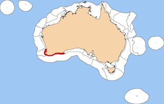
The Central Western Shelf Province, also known as the Shark Bay marine ecoregion, [1] is a biogeographic region of Australia's continental shelf and coastal waters. It includes the subtropical coastal waters of Western Australia. [2]
The Central Western Shelf Province, also known as the Shark Bay marine ecoregion, [1] is a biogeographic region of Australia's continental shelf and coastal waters. It includes the subtropical coastal waters of Western Australia. [2]
The Central Western Shelf Province includes the subtropical coastal waters and continental shelf along Western Australia's west coast, extending from Gnaraloo Bay to Kalbarri. It bounded on the north by the Central Western Shelf Transition, or Ningaloo Coast, which is a transitional zone between the subtropical and tropical coastal waters. On the south it is bounded by the Southwest Shelf Transition, a transition from subtropical waters to the warm temperate waters further south. The warm Leeuwin Current runs southwards along the coast. [3]
The continental shelf is narrow. The coastline is generally rocky with narrow fringing reefs, and exposed to high-energy swells from the Indian Ocean. The Zuytdorp Cliffs are dramatic limestone seacliffs which extend along the southern coastline from the northern tip of the Edel Land peninsula to the mouth of the Murchison River near Kalbarri. [3]
Shark Bay is a large sheltered embayment, nearly enclosed by Bernier, Dorre, and Dirk Hartog islands and Edel Land. [3]
The biota of the province is characterised by a suite of subtropical species, whose range generally extends northwards along the Ningaloo Coast, and southwards into the South Western Shelf Transition, particularly the Houtman Abrolhos reefs and Archipelago. This faunal community was recognised in Barry Hutchins' survey of reef fish (1994), and represents the southern part of G. P. Whitley’s (1937) Dampierian Province. [3]
Shark Bay is the largest and most ecologically important embayment between Exmouth Gulf and Cockburn Sound. It is home to extensive seagrass meadows and calcareous sand banks which provide habitat for rich and diverse communities of fishes, invertebrates, and macrophytic algae, along with a significant dugong (Dugong dugon) population. Stromatolites, rare colonies of cyanobacteria and other bacteria which form microbial mats up to a meter high, are found in sheltered lagoons. Shark Bay was designated a World Heritage Site in 1991. [3]
The Integrated Marine and Coastal Regionalisation of Australia (IMCRA) identifies two meso-scale bioregions that make up the transition:

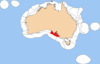
Shark Bay is a World Heritage Site in the Gascoyne region of Western Australia. The 23,000-square-kilometre (8,900 sq mi) area is located approximately 800 kilometres (500 mi) north of Perth, on the westernmost point of the Australian continent. UNESCO's official listing of Shark Bay as a World Heritage Site reads:

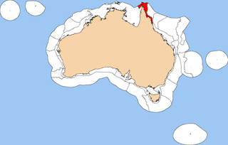
The Ningaloo Coast is a World Heritage Site located in the north west coastal region of Western Australia. The 705,015-hectare (1,742,130-acre) heritage-listed area is located approximately 1,200 kilometres (750 mi) north of Perth, along the East Indian Ocean. The distinctive Ningaloo Reef that fringes the Ningaloo Coast is 260 kilometres (160 mi) long and is Australia's largest fringing coral reef and the only large reef positioned very close to a landmass. The Muiron Islands and Cape Farquhar are within this coastal zone.

Yalgoo is an interim Australian bioregion located in Western Australia. It has an area of 5,087,577 hectares. The bioregion, together with the Avon Wheatbelt and Geraldton Sandplains bioregions, is part of the larger Southwest Australia savanna ecoregion as classified by the World Wildlife Fund.

The Bass Strait Shelf Province is a biogeographic region of Australia's coastal and continental shelf waters. It covers the central Bass Strait between Tasmania and the southern Australian mainland. It is a provincial level bioregion in the Integrated Marine and Coastal Regionalisation of Australia (IMCRA) system. The Bassian and adjacent Tasmanian Shelf provinces correspond to the Bassian marine ecoregion in the WWF's Marine Ecoregions of the World system.

The Central Eastern Shelf Province is a biogeographic region of Australia's coastal and continental shelf waters. It includes the warm temperate coastal waters of eastern Australia. It is a provincial level bioregion in the Integrated Marine and Coastal Regionalisation of Australia (IMCRA) system. It corresponds to the Manning-Hawkesbury marine ecoregion in the WWF's Marine Ecoregions of the World system.

Tweed–Moreton, also known as the Central Eastern Shelf Transition, is a marine biogeographic region of eastern Australia.

The Northeast Shelf Province is a biogeographic region of Australia's coastal and continental shelf waters. It includes the tropical coastal waters of the central and southern Great Barrier Reef in northeastern Australia. It is a provincial level bioregion in the Integrated Marine and Coastal Regionalisation of Australia (IMCRA) system. It corresponds to the Central and Southern Great Barrier Reef marine ecoregion in the WWF's Marine Ecoregions of the World system.
The Northeast Shelf Transition is a biogeographic region of Australia's coastal and continental shelf waters. It includes the tropical coastal waters of the northern Great Barrier Reef and the Torres Strait in northeastern-most Australia. It is a provincial level bioregion in the Integrated Marine and Coastal Regionalisation of Australia (IMCRA) system. It corresponds to the Torres Strait and Northern Great Barrier Reef marine ecoregion in the WWF's Marine Ecoregions of the World system.

The Northern Shelf Province, also known as Arnhem Coast to Gulf of Carpentaria, is a biogeographic region of Australia's continental shelf. It includes the coastal waters of Arnhem Land and the Gulf of Carpentaria in Northern Australia.

The Northwest Shelf Province, also known as Exmouth to Broome, is a biogeographic region of Australia's continental shelf.

The Northwest Shelf Transition, also known as Bonaparte Coast, is a biogeographic region of Australia's continental shelf. It adjoins the Kimberley region of Western Australia and the adjacent coast of the Northern Territory.

The Southeast Shelf Transition is a biogeographic region of Australia's coastal and continental shelf waters. It covers a portion of Australia's southeastern coast, from southern New South Wales to eastern Victoria, including the islands of the Kent Group and Furneaux Group at the eastern end of the Bass Strait. It is a provincial level bioregion in the Integrated Marine and Coastal Regionalisation of Australia (IMCRA) system, and is a transitional region between the warm temperate Central Eastern Shelf Province to the northwest and the cool temperate Bass Strait Shelf and Tasmanian Shelf provinces to the west and south. It corresponds to the Cape Howe marine ecoregion in the WWF's Marine Ecoregions of the World system.
The Southwest Shelf Province, also known as the Leeuwin marine ecoregion, is a biogeographic region of Australia's continental shelf. It includes the temperate coastal waters of Southwest Australia.

The Southwest Shelf Transition, also known as the Houtman marine ecoregion, is a biogeographic region of Australia's continental shelf and coastal waters. It includes the subtropical coastal waters of Southwest Australia.
The Spencer Gulf Shelf Province, also known as the South Australian Gulfs marine ecoregion, is a biogeographic region of Australia's continental shelf and coastal waters. It includes the warm temperate coastal waters of South Australia's central coast. It is a provincial bioregion in the Integrated Marine and Coastal Regionalisation of Australia (IMCRA) system.

The Tasmanian Shelf Province is a biogeographic region of Tasmania's coastal and continental shelf waters. It covers the western, eastern, and southern coasts of Tasmania. It is a provincial level bioregion in the Integrated Marine and Coastal Regionalisation of Australia (IMCRA) system. The Tasmanian Shelf and adjacent Bass Strait Shelf provinces correspond to the Bassian marine ecoregion in the WWF's Marine Ecoregions of the World system.

The Western Bass Strait Shelf Transition is a biogeographic region of Australia's coastal and continental shelf waters. It is a transitional region between the cold-temperate Bass Strait Shelf and Tasmanian Shelf provinces and the warm-temperate Spencer Gulf Shelf Province. It is a provincial bioregion in the Integrated Marine and Coastal Regionalisation of Australia (IMCRA) system. It is the southern portion of the Western Bassian marine ecoregion in the World Wildlife Fund's (WWF) Marine Ecoregions of the World system.

Temperate Australasia is a biogeographic region of the Earth's seas, comprising the temperate and subtropical waters of Australia and New Zealand, including both the Indian Ocean and Pacific coasts of the continent and adjacent islands.
The Bassian ecoregion is a biogeographic region of Australia's coastal and continental shelf waters. It includes the cold-temperate waters surrounding Tasmania, including the central Bass Strait between Tasmania and the southern Australian mainland. This ecoregion, designated in the Marine Ecoregions of the World system by the World Wildlife Fund (WWF), includes both the Bass Strait Shelf and Tasmanian Shelf provincial level bioregions from the Integrated Marine and Coastal Regionalisation of Australia (IMCRA) system.