Related Research Articles

North Atlantic Deep Water (NADW) is a deep water mass formed in the North Atlantic Ocean. Thermohaline circulation of the world's oceans involves the flow of warm surface waters from the southern hemisphere into the North Atlantic. Water flowing northward becomes modified through evaporation and mixing with other water masses, leading to increased salinity. When this water reaches the North Atlantic, it cools and sinks through convection, due to its decreased temperature and increased salinity resulting in increased density. NADW is the outflow of this thick deep layer, which can be detected by its high salinity, high oxygen content, nutrient minima, high 14C/12C, and chlorofluorocarbons (CFCs).

Salinity is the saltiness or amount of salt dissolved in a body of water, called saline water. It is usually measured in g/L or g/kg.

Downwelling is the downward movement of a fluid parcel and its properties within a larger fluid. It is closely related to upwelling, the upward movement of fluid.

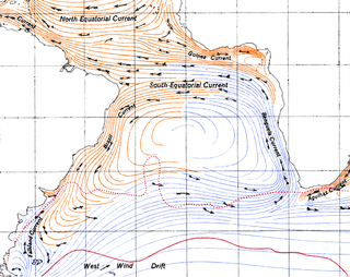
An ocean current is a continuous, directed movement of seawater generated by a number of forces acting upon the water, including wind, the Coriolis effect, breaking waves, cabbeling, and temperature and salinity differences. Depth contours, shoreline configurations, and interactions with other currents influence a current's direction and strength. Ocean currents are primarily horizontal water movements.

In oceanography, a gyre is any large system of circulating ocean surface currents, particularly those involved with large wind movements. Gyres are caused by the Coriolis effect; planetary vorticity, horizontal friction and vertical friction determine the circulatory patterns from the wind stress curl (torque).

The East Greenland Current (EGC) is a cold, low-salinity current that extends from Fram Strait (~80N) to Cape Farewell (~60N). The current is located off the eastern coast of Greenland along the Greenland continental margin. The current cuts through the Nordic Seas and through the Denmark Strait. The current is of major importance because it directly connects the Arctic to the Northern Atlantic, it is a major contributor to sea ice export out of the Arctic, and it is a major freshwater sink for the Arctic.
The Kuroshio Current, also known as the Black Current or Japan Current is a north-flowing, warm ocean current on the west side of the North Pacific Ocean basin. It was named for the deep blue appearance of its waters. Similar to the Gulf Stream in the North Atlantic, the Kuroshio is a powerful western boundary current that transports warm equatorial water poleward and forms the western limb of the North Pacific Subtropical Gyre. Off the East Coast of Japan, it merges with the Oyashio Current to form the North Pacific Current.

The Oyashio Current, also known as the Okhotsk Current or Kurile Current, is a cold subarctic ocean current that flows south and circulates counterclockwise in the western North Pacific Ocean. The waters of the Oyashio Current originate in the Arctic Ocean and flow southward via the Bering Sea, passing through the Bering Strait and transporting cold water from the Arctic Sea into the Pacific Ocean and the Sea of Okhotsk. It collides with the Kuroshio Current off the eastern shore of Japan to form the North Pacific Current . The nutrient-rich Oyashio is named for its metaphorical role as the parent that provides for and nurtures marine organisms.

The North Atlantic Gyre of the Atlantic Ocean is one of five great oceanic gyres. It is a circular ocean current, with offshoot eddies and sub-gyres, across the North Atlantic from the Intertropical Convergence Zone to the part south of Iceland, and from the east coasts of North America to the west coasts of Europe and Africa.

The Florida Current is a thermal ocean current that flows from the Straits of Florida around the Florida Peninsula and along the southeastern coast of the United States before joining the Gulf Stream Current near Cape Hatteras. Its contributing currents are the Loop Current and the Antilles Current. The current was discovered by Spanish explorer Juan Ponce de León in 1513.

The North Pacific Current is an ocean current that flows west-to-east between 30 and 50 degrees north in the Pacific Ocean. The current forms the southern part of the North Pacific Subpolar Gyre and the northern part of the North Pacific Subtropical Gyre. The North Pacific Current is formed by the collision of the Kuroshio Current, running northward off the coast of Japan, and the Oyashio Current, which is a cold subarctic current that flows south and circulates counterclockwise along the western North Pacific Ocean. In the eastern North Pacific off southern British Columbia, it splits into the southward flowing cold water California Current and the northward flowing Alaska Current.
The Brazil Current is a warm water current that flows south along the Brazilian south coast to the mouth of the Río de la Plata.

The North Pacific Gyre (NPG) or North Pacific Subtropical Gyre (NPSG), located in the northern Pacific Ocean, is one of the five major oceanic gyres. This gyre covers most of the northern Pacific Ocean. It is the largest ecosystem on Earth, located between the equator and 50° N latitude, and comprising 20 million square kilometers. The gyre has a clockwise circular pattern and is formed by four prevailing ocean currents: the North Pacific Current to the north, the California Current to the east, the North Equatorial Current to the south, and the Kuroshio Current to the west. It is the site of an unusually intense collection of human-created marine debris, known as the Great Pacific Garbage Patch.

A flow tracer is any fluid property used to track the flow velocity and circulation patterns. Tracers can be chemical properties, such as radioactive material, or chemical compounds, physical properties, such as density, temperature, salinity, or dyes, and can be natural or artificially induced. Flow tracers are used in many fields, such as physics, hydrology, limnology, oceanography, environmental studies and atmospheric studies.

The Ross Gyre is one of three gyres that exists within the Southern Ocean around Antarctica, the others being the Weddell Gyre and Balleny Gyre. The Ross Gyre is located north of the Ross Sea, and rotates clockwise. The gyre is formed by interactions between the Antarctic Circumpolar Current and the Antarctic Continental Shelf. The Ross Gyre is bounded by the Polar Front of the Antarctic Circumpolar Current to the north, the Antarctic Slope Current to the south, the Balleny Gyre to the west, and a variable boundary to the east from semiannual changes in sea surface height (SSH) in the Amundsen Sea. Circulation in the Ross Gyre has been estimated to be 20 ± 5 Sverdrup (Sv) and plays a large role in heat exchange in this region.
Brine rejection is a process that occurs when salty water freezes. The salts do not fit in the crystal structure of water ice, so the salt is expelled.

Mode water is defined as a particular type of water mass, which is nearly vertically homogeneous. Its vertical homogeneity is caused by the deep vertical convection in winter. The first term to describe this phenomenon is 18° water, which was used by Valentine Worthington to describe the isothermal layer in the northern Sargasso Sea cooling to a temperature of about 18 °C each winter. Then Masuzawa introduced the subtropical mode water concept to describe the thick layer of temperature 16–18 °C in the northwestern North Pacific subtropical gyre, on the southern side of the Kuroshio Extension. The terminology mode water was extended to the thick near-surface layer north of the Subantarctic Front by McCartney, who identified and mapped the properties of the Subantarctic mode water (SAMW). After that, McCartney and Talley then applied the term subpolar mode water (SPMW) to the thick near-surface mixed layers in the North Atlantic’s subpolar gyre.
Labrador Sea Water is an intermediate water mass characterized by cold water, relatively low salinity compared to other intermediate water masses, and high concentrations of both oxygen and anthropogenic tracers. It is formed by convective processes in the Labrador Sea located between Greenland and the northeast coast of the Labrador Peninsula. Deep convection in the Labrador Sea allows colder water to sink forming this water mass, which is a contributor to the upper layer of North Atlantic Deep Water. North Atlantic Deep Water flowing southward is integral to the Atlantic Meridional Overturning Circulation. The Labrador Sea experiences a net heat loss to the atmosphere annually.

Haida Eddies are episodic, clockwise rotating ocean eddies that form during the winter off the west coast of British Columbia's Haida Gwaii and Alaska's Alexander Archipelago. These eddies are notable for their large size, persistence, and frequent recurrence. Rivers flowing off the North American continent supply the continental shelf in the Hecate Strait with warmer, fresher, and nutrient-enriched water. Haida eddies are formed every winter when this rapid outflow of water through the strait wraps around Cape St. James at the southern tip of Haida Gwaii, and meets with the cooler waters of the Alaska Current. This forms a series of plumes which can merge into large eddies that are shed into the northeast Pacific Ocean by late winter, and may persist for up to two years.
LuAnn Thompson is the Walters Endowed Professor at the University of Washington. She is known for her work in modeling the movement of heat and chemicals via ocean currents.
References
- ↑ Talley, Lynne D. (1993-03-01). "Distribution and Formation of North Pacific Intermediate Water". Journal of Physical Oceanography. 23 (3): 517–537. Bibcode:1993JPO....23..517T. doi: 10.1175/1520-0485(1993)023<0517:DAFONP>2.0.CO;2 . ISSN 0022-3670.
- ↑ Talley, Lynne D.; Nagata, Yukata; Fujimura, Masahiko; Iwao, Takanori; Kono, Tokihiro; Inagake, Denzou; Hirai, Mitsuyuki; Okuda, Kuniaki (1995-04-01). "North Pacific Intermediate Water in the Kuroshio/Oyashio Mixed Water Region". Journal of Physical Oceanography. 25 (4): 475–501. Bibcode:1995JPO....25..475T. doi: 10.1175/1520-0485(1995)025<0475:NPIWIT>2.0.CO;2 . ISSN 0022-3670.
- ↑ Yasuda, Ichiro (1997). "The origin of the North Pacific Intermediate Water". Journal of Geophysical Research: Oceans. 102 (C1): 893–909. Bibcode:1997JGR...102..893Y. doi:10.1029/96JC02938. ISSN 2156-2202.
- ↑ You, Yuzhu; Suginohara, Nobuo; Fukasawa, Masao; Yasuda, Ichiro; Kaneko, Ikuo; Yoritaka, Hiroyuki; Kawamiya, Michio (2000). "Roles of the Okhotsk Sea and Gulf of Alaska in forming the North Pacific Intermediate Water". Journal of Geophysical Research: Oceans. 105 (C2): 3253–3280. Bibcode:2000JGR...105.3253Y. doi:10.1029/1999JC900304. ISSN 2156-2202.
- Shimizu, Y., T. Iwao, I. Yasuda, S. Ito, T. Watanabe, K. Uehara, N. Shikama, and T. Nakano, 2004: Formation process of North Pacific intermediate water revealed by profiling floats set to drift on 26.7 σθ isopycnal surface. J. Oceanogr., 60, 453–462.
- Talley, L., Y. Nagata, M. Fujimura, T. Kono, D. Inagake, M. Hirai, and K. Okuda, 1995: North Pacific intermediate water in the Kuroshio/Oyashio mixed water region. J. Phys. Oceanogr.,25, 475–501.