Related Research Articles

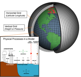
Numerical climate models use quantitative methods to simulate the interactions of the important drivers of climate, including atmosphere, oceans, land surface and ice. They are used for a variety of purposes from study of the dynamics of the climate system to projections of future climate. Climate models may also be qualitative models and also narratives, largely descriptive, of possible futures.

A general circulation model (GCM) is a type of climate model. It employs a mathematical model of the general circulation of a planetary atmosphere or ocean. It uses the Navier–Stokes equations on a rotating sphere with thermodynamic terms for various energy sources. These equations are the basis for computer programs used to simulate the Earth's atmosphere or oceans. Atmospheric and oceanic GCMs are key components along with sea ice and land-surface components.

Radiative forcing is the change in energy flux in the atmosphere caused by natural or anthropogenic factors of climate change as measured in watts per meter squared. It is a scientific concept used to quantify and compare the external drivers of change to Earth's energy balance. These external drivers are distinguished from climate feedbacks and internal variability, which also influence the direction and magnitude of imbalance.

Clouds and the Earth's Radiant Energy System (CERES) is on-going NASA climatological experiment from Earth orbit. The CERES are scientific satellite instruments, part of the NASA's Earth Observing System (EOS), designed to measure both solar-reflected and Earth-emitted radiation from the top of the atmosphere (TOA) to the Earth's surface. Cloud properties are determined using simultaneous measurements by other EOS instruments such as the Moderate Resolution Imaging Spectroradiometer (MODIS). Results from the CERES and other NASA missions, such as the Earth Radiation Budget Experiment (ERBE), could enable nearer to real-time tracking of Earth's energy imbalance and better understanding of the role of clouds in global climate change.
The Community Climate System Model (CCSM) is a coupled general circulation model (GCM) developed by the University Corporation for Atmospheric Research (UCAR) with funding from the National Science Foundation (NSF), the Department of Energy (DoE), and the National Aeronautics and Space Administration (NASA). The coupled components include an atmospheric model, a land-surface model, an ocean model, and a sea ice model. CCSM is maintained by the National Center for Atmospheric Research (NCAR).

Earth's energy budget accounts for the balance between the energy that Earth receives from the Sun and the energy the Earth loses back into outer space. Smaller energy sources, such as Earth's internal heat, are taken into consideration, but make a tiny contribution compared to solar energy. The energy budget also accounts for how energy moves through the climate system. Because the Sun heats the equatorial tropics more than the polar regions, received solar irradiance is unevenly distributed. As the energy seeks equilibrium across the planet, it drives interactions in Earth's climate system, i.e., Earth's water, ice, atmosphere, rocky crust, and all living things. The result is Earth's climate.

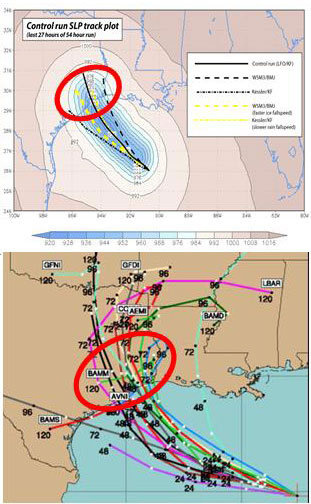
Numerical weather prediction (NWP) uses mathematical models of the atmosphere and oceans to predict the weather based on current weather conditions. Though first attempted in the 1920s, it was not until the advent of computer simulation in the 1950s that numerical weather predictions produced realistic results. A number of global and regional forecast models are run in different countries worldwide, using current weather observations relayed from radiosondes, weather satellites and other observing systems as inputs.

Ensemble forecasting is a method used in or within numerical weather prediction. Instead of making a single forecast of the most likely weather, a set of forecasts is produced. This set of forecasts aims to give an indication of the range of possible future states of the atmosphere. Ensemble forecasting is a form of Monte Carlo analysis. The multiple simulations are conducted to account for the two usual sources of uncertainty in forecast models: (1) the errors introduced by the use of imperfect initial conditions, amplified by the chaotic nature of the evolution equations of the atmosphere, which is often referred to as sensitive dependence on initial conditions; and (2) errors introduced because of imperfections in the model formulation, such as the approximate mathematical methods to solve the equations. Ideally, the verified future atmospheric state should fall within the predicted ensemble spread, and the amount of spread should be related to the uncertainty (error) of the forecast. In general, this approach can be used to make probabilistic forecasts of any dynamical system, and not just for weather prediction.

In atmospheric science, an atmospheric model is a mathematical model constructed around the full set of primitive, dynamical equations which govern atmospheric motions. It can supplement these equations with parameterizations for turbulent diffusion, radiation, moist processes, heat exchange, soil, vegetation, surface water, the kinematic effects of terrain, and convection. Most atmospheric models are numerical, i.e. they discretize equations of motion. They can predict microscale phenomena such as tornadoes and boundary layer eddies, sub-microscale turbulent flow over buildings, as well as synoptic and global flows. The horizontal domain of a model is either global, covering the entire Earth, or regional (limited-area), covering only part of the Earth. The different types of models run are thermotropic, barotropic, hydrostatic, and nonhydrostatic. Some of the model types make assumptions about the atmosphere which lengthens the time steps used and increases computational speed.

Earth's climate system is a complex system having five interacting components: the atmosphere (air), the hydrosphere (water), the cryosphere, the lithosphere and the biosphere. Climate is the statistical characterization of the climate system, representing the average weather, typically over a period of 30 years, and is determined by a combination of processes in the climate system, such as ocean currents and wind patterns. Circulation in the atmosphere and oceans is primarily driven by solar radiation and transports heat from the tropical regions to regions that receive less energy from the Sun. The water cycle also moves energy throughout the climate system. In addition, different chemical elements, necessary for life, are constantly recycled between the different components.
Geophysical Fluid Dynamics Laboratory Coupled Model is a coupled atmosphere–ocean general circulation model (AOGCM) developed at the NOAA Geophysical Fluid Dynamics Laboratory in the United States. It is one of the leading climate models used in the Fourth Assessment Report of the IPCC, along with models developed at the Max Planck Institute for Climate Research, the Hadley Centre and the National Center for Atmospheric Research.

In meteorology and climatology, a mesonet, portmanteau of mesoscale network, is a network of automated weather and, often also including environmental monitoring stations, designed to observe mesoscale meteorological phenomena and/or microclimates.
An atmospheric reanalysis is a meteorological and climate data assimilation project which aims to assimilate historical atmospheric observational data spanning an extended period, using a single consistent assimilation scheme throughout.
The Climate Forecast System or coupled forecast system is a medium to long range numerical weather prediction and a climate model run by the National Centers for Environmental Prediction (NCEP) to bridge weather and climate timescales. Version 2 became operational as CFSv2 in 2011.
Ocean general circulation models (OGCMs) are a particular kind of general circulation model to describe physical and thermodynamical processes in oceans. The oceanic general circulation is defined as the horizontal space scale and time scale larger than mesoscale. They depict oceans using a three-dimensional grid that include active thermodynamics and hence are most directly applicable to climate studies. They are the most advanced tools currently available for simulating the response of the global ocean system to increasing greenhouse gas concentrations. A hierarchy of OGCMs have been developed that include varying degrees of spatial coverage, resolution, geographical realism, process detail, etc.
The North American Ensemble Forecast System (NAEFS) is a joint project involving the Meteorological Service of Canada (MSC) in Canada, the National Weather Service (NWS) in the United States, and the National Meteorological Service of Mexico (NMSM) in Mexico providing numerical weather prediction ensemble guidance for the 1- to 16-day forecast period. The NAEFS combines the Canadian MSC and the US NWS global ensemble prediction systems, improving probabilistic operational guidance over what can be built from any individual country's ensemble. Model guidance from the NAEFS is incorporated into the forecasts of the respective national agencies.
The Model for Prediction Across Scales (MPAS) is an Earth system modeling software that integrates atmospheric, oceanographic, and cryospheric modeling across scales from regional to planetary. It includes climate and weather modeling and simulations that were used initially by researchers in 2013. The atmospheric models were created by the Earth System Laboratory at the National Center for Atmospheric Research and the oceanographic models were created by the Climate, Ocean, and Sea Ice Modeling Group at Los Alamos National Laboratory. The software has been used to model real-time weather as well as seasonal forecasting of convection, tornadoes and tropical cyclones. The atmospheric modeling component of the software can be used with other atmospheric modeling software including the Weather Research and Forecasting Model, the Global Forecast System, and the Community Earth System Model.
CICE is a computer model that simulates the growth, melt and movement of sea ice. It has been integrated into many coupled climate system models as well as global ocean and weather forecasting models and is often used as a tool in Arctic and Southern Ocean research. CICE development began in the mid-1990s by the United States Department of Energy (DOE), and it is currently maintained and developed by a group of institutions in North America and Europe known as the CICE Consortium. Its widespread use in earth system science in part owes to the importance of sea ice in determining Earth's planetary albedo, the strength of the global thermohaline circulation in the world's oceans, and in providing surface boundary conditions for atmospheric circulation models, since sea ice occupies a significant proportion (4-6%) of earth's surface. CICE is a type of cryospheric model.
Bette Otto-Bliesner is an earth scientist known for her modeling of Earth's past climate and its changes over different geological eras.

Fixed anvil temperature hypothesis is a physical hypothesis that describes the response of cloud radiative properties to rising surface temperatures. It presumes that the temperature at which radiation is emitted by anvil clouds is constrained by radiative processes and thus does not change in response to surface warming. Since the amount of radiation emitted by clouds is a function of their temperature, it implies that it does not increase with surface warming and thus a warmer surface does not increase radiation emissions by cloud tops. The mechanism has been identified both in climate models and observations of cloud behaviour, it affects how much the world heats up for each extra tonne of greenhouse gas in the atmosphere. However, some evidence suggests that it may be more correctly formulated as decreased anvil warming rather than no anvil warming.
References
- ↑ Hurrell, James W.; M. M. Holland; P. R. Gent (2013). "The Community Earth System Model: A Framework for Collaborative Research". Bulletin of the American Meteorological Society . 94 (9): 1339–60. Bibcode:2013BAMS...94.1339H. doi:10.1175/BAMS-D-12-00121.1. OSTI 1565081. S2CID 24603627.
- ↑ Kay, J. E.; et al. (2014). "The Community Earth System Model (CESM) Large Ensemble Project: A Community Resource for Studying Climate Change in the Presence of Internal Climate Variability". Bull. Am. Meteorol. Soc. 96 (8): 1333–1349. Bibcode:2015BAMS...96.1333K. doi: 10.1175/BAMS-D-13-00255.1 .
- ↑ CESM: Models Archived 2015-04-11 at the Wayback Machine