Related Research Articles

Evapotranspiration (ET) is the combined processes which move water from the Earth's surface into the atmosphere. It covers both water evaporation and transpiration. Evapotranspiration is an important part of the local water cycle and climate, and measurement of it plays a key role in agricultural irrigation and water resource management.

A general circulation model (GCM) is a type of climate model. It employs a mathematical model of the general circulation of a planetary atmosphere or ocean. It uses the Navier–Stokes equations on a rotating sphere with thermodynamic terms for various energy sources. These equations are the basis for computer programs used to simulate the Earth's atmosphere or oceans. Atmospheric and oceanic GCMs are key components along with sea ice and land-surface components.

Groundwater is the water present beneath Earth's surface in rock and soil pore spaces and in the fractures of rock formations. About 30 percent of all readily available freshwater in the world is groundwater. A unit of rock or an unconsolidated deposit is called an aquifer when it can yield a usable quantity of water. The depth at which soil pore spaces or fractures and voids in rock become completely saturated with water is called the water table. Groundwater is recharged from the surface; it may discharge from the surface naturally at springs and seeps, and can form oases or wetlands. Groundwater is also often withdrawn for agricultural, municipal, and industrial use by constructing and operating extraction wells. The study of the distribution and movement of groundwater is hydrogeology, also called groundwater hydrology.
In climatology, the Coupled Model Intercomparison Project (CMIP) is a collaborative framework designed to improve knowledge of climate change. It was organized in 1995 by the Working Group on Coupled Modelling (WGCM) of the World Climate Research Programme (WCRP). It is developed in phases to foster the climate model improvements but also to support national and international assessments of climate change. A related project is the Atmospheric Model Intercomparison Project (AMIP) for global coupled ocean-atmosphere general circulation models (GCMs).
C4MIP (more fully, Coupled Climate Carbon Cycle Model Intercomparison Project) is a joint project between the International Geosphere-Biosphere Programme (IGBP) and the World Climate Research Programme (WCRP). It is a model intercomparison project along the lines of the Atmospheric Model Intercomparison Project, but for global climate models that include an interactive carbon cycle.
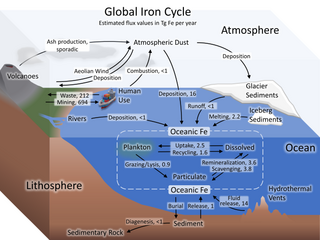
The iron cycle (Fe) is the biogeochemical cycle of iron through the atmosphere, hydrosphere, biosphere and lithosphere. While Fe is highly abundant in the Earth's crust, it is less common in oxygenated surface waters. Iron is a key micronutrient in primary productivity, and a limiting nutrient in the Southern ocean, eastern equatorial Pacific, and the subarctic Pacific referred to as High-Nutrient, Low-Chlorophyll (HNLC) regions of the ocean.
The Canadian Centre for Climate Modelling and Analysis (CCCma) is part of the Climate Research Division of Environment Canada and is located at the University of Victoria, Victoria, British Columbia. Its purpose is to develop and apply climate models to improve understanding of climate change and make quantitative projections of future climate in Canada and globally. Its seasonal forecasting system provides climate forecasts over Canada on timescales of months to years.
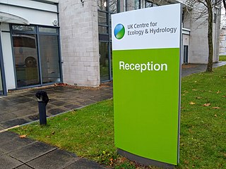
The UK Centre for Ecology & Hydrology (UKCEH) is a centre for excellence in environmental science across water, land and air. The organisation has a long history of investigating, monitoring and modelling environmental change. Research topics include: air pollution, biodiversity, chemical risks in the environment, extreme weather events, droughts, floods, greenhouse gas emissions, soil health, sustainable agriculture, sustainable ecosystems, water quality, and water resources management.

Tropical peat is a type of histosol that is found in tropical latitudes, including South East Asia, Africa, and Central and South America. Tropical peat mostly consists of dead organic matter from trees instead of spaghnum which are commonly found in temperate peat. This soils usually contain high organic matter content, exceeding 75% with dry low bulk density around 0.2 mg/m3 (0.0 gr/cu ft).
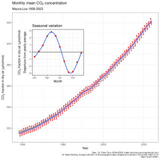
In Earth's atmosphere, carbon dioxide is a trace gas that plays an integral part in the greenhouse effect, carbon cycle, photosynthesis and oceanic carbon cycle. It is one of several greenhouse gases in the atmosphere of Earth. The current global average concentration of CO2 in the atmosphere is 421 ppm as of May 2022 (0.04%). This is an increase of 50% since the start of the Industrial Revolution, up from 280 ppm during the 10,000 years prior to the mid-18th century. The increase is due to human activity. Burning fossil fuels is the main cause of these increased CO2 concentrations and also the main cause of climate change. Other large anthropogenic sources include cement production, deforestation, and biomass burning.
Integrated assessment modelling (IAM) or integrated modelling (IM) is a term used for a type of scientific modelling that tries to link main features of society and economy with the biosphere and atmosphere into one modelling framework. The goal of integrated assessment modelling is to accommodate informed policy-making, usually in the context of climate change though also in other areas of human and social development. While the detail and extent of integrated disciplines varies strongly per model, all climatic integrated assessment modelling includes economic processes as well as processes producing greenhouse gases. Other integrated assessment models also integrate other aspects of human development such as education, health, infrastructure, and governance.
The Unified Model is a numerical weather prediction and climate modeling software suite originally developed by the United Kingdom Met Office, and now both used and further developed by many weather-forecasting agencies around the world. The Unified Model gets its name because a single model is used across a range of both timescales and spatial scales. The models are grid-point based, rather than wave based, and are run on a variety of supercomputers around the world. The Unified Model atmosphere can be coupled to a number of ocean models. At the Met Office it is used for the main suite of Global Model, North Atlantic and Europe model (NAE) and a high-resolution UK model (UKV), in addition to a variety of Crisis Area Models and other models that can be run on demand. Similar Unified Model suites with global and regional domains are used by many other national or military weather agencies around the world for operational forecasting.
A Dynamic Global Vegetation Model (DGVM) is a computer program that simulates shifts in potential vegetation and its associated biogeochemical and hydrological cycles as a response to shifts in climate. DGVMs use time series of climate data and, given constraints of latitude, topography, and soil characteristics, simulate monthly or daily dynamics of ecosystem processes. DGVMs are used most often to simulate the effects of future climate change on natural vegetation and its carbon and water cycles.

Climate change feedbacks are effects of global warming that amplify or diminish the effect of forces that initially cause the warming. Positive feedbacks enhance global warming while negative feedbacks weaken it. Feedbacks are important in the understanding of climate change because they play an important part in determining the sensitivity of the climate to warming forces. Climate forcings and feedbacks together determine how much and how fast the climate changes. Large positive feedbacks can lead to tipping points—abrupt or irreversible changes in the climate system—depending upon the rate and magnitude of the climate change.
Ocean general circulation models (OGCMs) are a particular kind of general circulation model to describe physical and thermodynamical processes in oceans. The oceanic general circulation is defined as the horizontal space scale and time scale larger than mesoscale. They depict oceans using a three-dimensional grid that include active thermodynamics and hence are most directly applicable to climate studies. They are the most advanced tools currently available for simulating the response of the global ocean system to increasing greenhouse gas concentrations. A hierarchy of OGCMs have been developed that include varying degrees of spatial coverage, resolution, geographical realism, process detail, etc.
The Nucleus for European Modeling of the Ocean (NEMO) is a general model of ocean circulation developed by a European consortium and used in many countries of Europe.
CICE is a computer model that simulates the growth, melt and movement of sea ice. It has been integrated into many coupled climate system models as well as global ocean and weather forecasting models and is often used as a tool in Arctic and Southern Ocean research. CICE development began in the mid-1990s by the United States Department of Energy (DOE), and it is currently maintained and developed by a group of institutions in North America and Europe known as the CICE Consortium. Its widespread use in earth system science in part owes to the importance of sea ice in determining Earth's planetary albedo, the strength of the global thermohaline circulation in the world's oceans, and in providing surface boundary conditions for atmospheric circulation models, since sea ice occupies a significant proportion (4-6%) of earth's surface. CICE is a type of cryospheric model.

The effects of climate change on the water cycle are profound and have been described as an intensification or a strengthening of the water cycle. This effect has been observed since at least 1980. One example is the intensification of heavy precipitation events. This has important negative effects on the availability of freshwater resources, as well as other water reservoirs such as oceans, ice sheets, atmosphere and land surface. The water cycle is essential to life on Earth and plays a large role in the global climate and the ocean circulation. The warming of our planet is expected to cause changes in the water cycle for various reasons. For example, warmer atmosphere can contain more water vapor which has effects on evaporation and rainfall.
OceanParcels, “Probably A Really Computationally Efficient Lagrangian Simulator”, is a set of python classes and methods that is used to track particles like water, plankton and plastics. It uses the output of Ocean General Circulation Models (OGCM's). OceanParcels main goal is to process the increasingly large amounts of data that is governed by OGCM's. The flow dynamics are simulated using Lagrangian modelling and the geophysical fluid dynamics are simulated with Eulerian modelling or provided through experimental data. OceanParcels is dependent on two principles, namely the ability to read external data sets from different formats and customizable kernels to define particle dynamics.
Helene Hewitt is a British climate scientist who is a research fellow at the Met Office. Her research considers climate and ocean models. Hewitt serves on the CLIVAR Ocean Model Development Panel. She was awarded an Order of the British Empire in the 2022 Birthday Honours.
References
- ↑ "Joint UK Land Environment Simulator (JULES)". Joint UK Land Environment Simulator (JULES). Retrieved 2020-08-19.
- 1 2 "Joint UK Land Environment Simulator (JULES)". Met Office . Retrieved 2020-08-19.
- ↑ Phelan, Matthew (7 August 2018). "Meeting Paris Agreement Global Warming Goals May Require Lots More Forests". Inverse. Retrieved 2020-08-15.
- ↑ "Climate impacts". Met Office. Retrieved 2020-08-19.
- ↑ Osborne, T.; Gornall, J.; Hooker, J.; Williams, K.; Wiltshire, A.; Betts, R.; Wheeler, T. (October 2014). "JULES-crop: a parametrisation of crops in the Joint UK Land Environment Simulator" (PDF). Geoscientific Model Development Discussions. 7 (5): 6773–6809. Bibcode:2014GMDD....7.6773O. doi: 10.5194/gmdd-7-6773-2014 .
- ↑ Best, M. J.; Pryor, M.; Clark, D. B.; Rooney, G. G.; Essery, R. L. H.; Ménard, C. B.; Edwards, J. M.; Hendry, M. A.; Porson, A.; Gedney, N.; Mercado, L. M. (2011). "The Joint UK Land Environment Simulator (JULES), model description – part 1: energy and water fluxes". Geoscientific Model Development. 4 (3): 677–699. Bibcode:2011GMD.....4..677B. doi: 10.5194/gmd-4-677-2011 . hdl: 20.500.11820/f4a1d33b-17bd-4b8b-8b72-c511ab7a5948 . ISSN 1991-9603.
- ↑ Yuan, Wenping; Zheng, Yi; Piao, Shilong; Ciais, Philippe; Lombardozzi, Danica; Wang, Yingping; Ryu, Youngryel; Chen, Guixing; Dong, Wenjie; Hu, Zhongming; Jain, Atul K. (2019-08-01). "Increased atmospheric vapor pressure deficit reduces global vegetation growth". Science Advances. 5 (8): eaax1396. Bibcode:2019SciA....5.1396Y. doi:10.1126/sciadv.aax1396. ISSN 2375-2548. PMC 6693914 . PMID 31453338.
- ↑ Yin, Yuanyuan; Tang, Qiuhong; Wang, Lixin; Liu, Xingcai (2016-02-12). "Risk and contributing factors of ecosystem shifts over naturally vegetated land under climate change in China". Scientific Reports. 6 (1): 20905. Bibcode:2016NatSR...620905Y. doi:10.1038/srep20905. ISSN 2045-2322. PMC 4751438 . PMID 26867481.
- ↑ Batelis, Stamatis-Christos; Rahman, Mostaquimur; Kollet, Stefan; Woods, Ross; Rosolem, Rafael (2020). "Towards the representation of groundwater in the Joint UK Land Environment Simulator". Hydrological Processes. 34 (13): 2843–2863. Bibcode:2020HyPr...34.2843B. doi: 10.1002/hyp.13767 . hdl: 1983/dbebc317-eec9-4bf7-9ef7-08f8d7b28423 . ISSN 1099-1085.
- ↑ Davies-Barnard, Taraka; Meyerholt, Johannes; Zaehle, Sönke; Friedlingstein, Pierre; Brovkin, Victor; Fan, Yuanchao; Fisher, Rosie A.; Jones, Chris D.; Lee, Hanna; Peano, Daniele; Smith, Benjamin; Wårlind, David; Wiltshire, Andy J. (2020). "Nitrogen Cycling in CMIP6 Land Surface Models: Progress and Limitations" (PDF). Biogeosciences (Preprint). 17 (20): 5129. Bibcode:2020BGeo...17.5129D. doi: 10.5194/bg-17-5129-2020 .