The National Weather Service (NWS) is an agency of the United States federal government that is tasked with providing weather forecasts, warnings of hazardous weather, and other weather-related products to organizations and the public for the purposes of protection, safety, and general information. It is a part of the National Oceanic and Atmospheric Administration (NOAA) branch of the Department of Commerce, and is headquartered in Silver Spring, Maryland, within the Washington metropolitan area. The agency was known as the United States Weather Bureau from 1890 until it adopted its current name in 1970.

The Weather Prediction Center (WPC), located in College Park, Maryland, is one of nine service centers under the umbrella of the National Centers for Environmental Prediction (NCEP), a part of the National Weather Service (NWS), which in turn is part of the National Oceanic and Atmospheric Administration (NOAA) of the U.S. Government. Until March 5, 2013 the Weather Prediction Center was known as the Hydrometeorological Prediction Center (HPC). The Weather Prediction Center serves as a center for quantitative precipitation forecasting, medium range forecasting, and the interpretation of numerical weather prediction computer models.

Numerical weather prediction (NWP) uses mathematical models of the atmosphere and oceans to predict the weather based on current weather conditions. Though first attempted in the 1920s, it was not until the advent of computer simulation in the 1950s that numerical weather predictions produced realistic results. A number of global and regional forecast models are run in different countries worldwide, using current weather observations relayed from radiosondes, weather satellites and other observing systems as inputs.

The United States National Centers for Environmental Prediction (NCEP) delivers national and global weather, water, climate and space weather guidance, forecasts, warnings and analyses to its Partners and External User Communities. These products and services are based on a service-science legacy and respond to user needs to protect life and property, enhance that nation's economy and support the nation's growing need for environmental information. The centers form part of the National Weather Service.

The Environmental Modeling Center (EMC) is a United States Government agency, which improves numerical weather, marine and climate predictions at the National Centers for Environmental Prediction (NCEP), through a broad program of research in data assimilation and modeling. In support of the NCEP operational forecasting mission, the EMC develops, improves and monitors data assimilation systems and models of the atmosphere, ocean and coupled system, using advanced methods developed internally as well as cooperatively with scientists from universities, NOAA laboratories and other government agencies, and the international scientific community.
The National Severe Storms Laboratory (NSSL) is a National Oceanic and Atmospheric Administration (NOAA) weather research laboratory under the Office of Oceanic and Atmospheric Research. It is one of seven NOAA Research Laboratories (RLs).

The Global Forecast System (GFS) is a global numerical weather prediction system containing a global computer model and variational analysis run by the United States' National Weather Service (NWS).

A tropical cyclone forecast model is a computer program that uses meteorological data to forecast aspects of the future state of tropical cyclones. There are three types of models: statistical, dynamical, or combined statistical-dynamic. Dynamical models utilize powerful supercomputers with sophisticated mathematical modeling software and meteorological data to calculate future weather conditions. Statistical models forecast the evolution of a tropical cyclone in a simpler manner, by extrapolating from historical datasets, and thus can be run quickly on platforms such as personal computers. Statistical-dynamical models use aspects of both types of forecasting. Four primary types of forecasts exist for tropical cyclones: track, intensity, storm surge, and rainfall. Dynamical models were not developed until the 1970s and the 1980s, with earlier efforts focused on the storm surge problem.

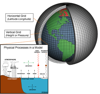
In atmospheric science, an atmospheric model is a mathematical model constructed around the full set of primitive, dynamical equations which govern atmospheric motions. It can supplement these equations with parameterizations for turbulent diffusion, radiation, moist processes, heat exchange, soil, vegetation, surface water, the kinematic effects of terrain, and convection. Most atmospheric models are numerical, i.e. they discretize equations of motion. They can predict microscale phenomena such as tornadoes and boundary layer eddies, sub-microscale turbulent flow over buildings, as well as synoptic and global flows. The horizontal domain of a model is either global, covering the entire Earth, or regional (limited-area), covering only part of the Earth. The different types of models run are thermotropic, barotropic, hydrostatic, and nonhydrostatic. Some of the model types make assumptions about the atmosphere which lengthens the time steps used and increases computational speed.

The Weather Research and Forecasting (WRF) Model is a numerical weather prediction (NWP) system designed to serve both atmospheric research and operational forecasting needs. NWP refers to the simulation and prediction of the atmosphere with a computer model, and WRF is a set of software for this. WRF features two dynamical (computational) cores, a data assimilation system, and a software architecture allowing for parallel computation and system extensibility. The model serves a wide range of meteorological applications across scales ranging from meters to thousands of kilometers.
TAMDAR is a weather monitoring system that consists of an in situ atmospheric sensor mounted on commercial aircraft for data gathering. It collects information similar to that collected by radiosondes carried aloft by weather balloons. It was developed by AirDat LLC, which was acquired by Panasonic Avionics Corporation in April 2013 and was operated until October 2018 under the name Panasonic Weather Solutions. It is now owned by FLYHT Aerospace Solutions Ltd.
In weather forecasting, model output statistics (MOS) is a multiple linear regression technique in which predictands, often near-surface quantities, are related statistically to one or more predictors. The predictors are typically forecasts from a numerical weather prediction (NWP) model, climatic data, and, if applicable, recent surface observations. Thus, output from NWP models can be transformed by the MOS technique into sensible weather parameters that are familiar to a layperson.
A wind power forecast corresponds to an estimate of the expected production of one or more wind turbines in the near future, up to a year. Forecast are usually expressed in terms of the available power of the wind farm, occasionally in units of energy, indicating the power production potential over a time interval.
The North American Mesoscale Model (NAM) is a numerical weather prediction model run by National Centers for Environmental Prediction for short-term weather forecasting. Currently, the Weather Research and Forecasting Non-hydrostatic Mesoscale Model (WRF-NMM) model system serves as the dynamical core of the NAM model. The WRF replaced the Eta model on June 13, 2006. The NAM is run four times a day out to 84 hours, with 12 km horizontal resolution and with three-hour temporal resolution, providing finer detail than other operational forecast models. Its ensemble is known as the Short Range Ensemble Forecast (SREF) and runs out 87 hours.
The NCEP/NCAR Reanalysis is an atmospheric reanalysis produced by the National Centers for Environmental Prediction (NCEP) and the National Center for Atmospheric Research (NCAR). It is a continually updated globally gridded data set that represents the state of the Earth's atmosphere, incorporating observations and numerical weather prediction (NWP) model output from 1948 to present.
An atmospheric reanalysis is a meteorological and climate data assimilation project which aims to assimilate historical atmospheric observational data spanning an extended period, using a single consistent assimilation scheme throughout.

The history of numerical weather prediction considers how current weather conditions as input into mathematical models of the atmosphere and oceans to predict the weather and future sea state has changed over the years. Though first attempted manually in the 1920s, it was not until the advent of the computer and computer simulation that computation time was reduced to less than the forecast period itself. ENIAC was used to create the first forecasts via computer in 1950, and over the years more powerful computers have been used to increase the size of initial datasets and use more complicated versions of the equations of motion. The development of global forecasting models led to the first climate models. The development of limited area (regional) models facilitated advances in forecasting the tracks of tropical cyclone as well as air quality in the 1970s and 1980s.
The Rapid Refresh is a numerical weather prediction (NWP) model. The model is designed to provide short-range hourly weather forecasts for North America. The Rapid Refresh was officially made operational on 1 May 2012, replacing the Rapid Update Cycle (RUC). The model also serves as the boundary conditions for the higher-resolution High Resolution Rapid Refresh (HRRR) model, that uses a 3 km (1.9 mi) grid spacing on a domain covering the continental United States.
The Climate Forecast System or coupled forecast system (CFS) is a medium to long range numerical weather prediction and a climate model run by the National Centers for Environmental Prediction (NCEP) to bridge weather and climate timescales. Version 2 became operational as CFSv2 in 2011.
The Flow-following, finite-volume Icosahedral Model (FIM) is an experimental numerical weather prediction model that was developed at the Earth System Research Laboratories in the United States from 2008 to 2016.


