List

The Seamounts plotted using Google Map overlay.
This is a list of Seamounts in the Southern Ocean. A seamount is a mountain rising from the ocean seafloor that does not reach to the water's surface (sea level), and thus is not an island, islet or Cliff-rock. Seamounts are typically formed from extinct volcanoes that rise abruptly and are usually found rising from the seafloor to 1,000–4,000 m (3,300–13,100 ft) in height. They are defined by oceanographers as independent features that rise to at least 1,000 m (3,281 ft) above the seafloor, characteristically of conical form. [1]
The Seamounts plotted using Google Map overlay.

Mount Erebus is the southernmost active volcano on Earth, located on Ross Island in the Ross Dependency in Antarctica. With a summit elevation of 3,792 metres (12,441 ft), it is the second most prominent mountain in Antarctica and the second-highest volcano in Antarctica. It is the highest point on Ross Island, which is also home to three inactive volcanoes: Mount Terror, Mount Bird, and Mount Terra Nova. It makes Ross Island the sixth-highest island on Earth.

In marine geology, a guyot, also called a tablemount, is an isolated underwater volcanic mountain (seamount) with a flat top more than 200 m (660 ft) below the surface of the sea. The diameters of these flat summits can exceed 10 km (6 mi). Guyots are most commonly found in the Pacific Ocean, but they have been identified in all the oceans except the Arctic Ocean. They are analogous to tables on land.

A seamount is a large submarine landform that rises from the ocean floor without reaching the water surface, and thus is not an island, islet, or cliff-rock. Seamounts are typically formed from extinct volcanoes that rise abruptly and are usually found rising from the seafloor to 1,000–4,000 m (3,300–13,100 ft) in height. They are defined by oceanographers as independent features that rise to at least 1,000 m (3,281 ft) above the seafloor, characteristically of conical form. The peaks are often found hundreds to thousands of meters below the surface, and are therefore considered to be within the deep sea. During their evolution over geologic time, the largest seamounts may reach the sea surface where wave action erodes the summit to form a flat surface. After they have subsided and sunk below the sea surface, such flat-top seamounts are called "guyots" or "tablemounts".
Kamaʻehuakanaloa Seamount is an active submarine volcano about 22 mi (35 km) off the southeast coast of the island of Hawaii. The top of the seamount is about 3,200 ft (975 m) below sea level. This seamount is on the flank of Mauna Loa, the largest active subaerial shield volcano on Earth. Kamaʻehuakanaloa is the newest volcano in the Hawaiian–Emperor seamount chain, a string of volcanoes that stretches about 3,900 mi (6,200 km) northwest of Kamaʻehuakanaloa. Unlike most active volcanoes in the Pacific Ocean that make up the active plate margins on the Pacific Ring of Fire, Kamaʻehuakanaloa and the other volcanoes of the Hawaiian–Emperor seamount chain are hotspot volcanoes and formed well away from the nearest plate boundary. Volcanoes in the Hawaiian Islands arise from the Hawaii hotspot, and as the youngest volcano in the chain, Kamaʻehuakanaloa is the only Hawaiian volcano in the deep submarine preshield stage of development.

Geologically, a volcanic island is an island of volcanic origin. The term high island can be used to distinguish such islands from low islands, which are formed from sedimentation or the uplifting of coral reefs.

Submarine volcanoes are underwater vents or fissures in the Earth's surface from which magma can erupt. Many submarine volcanoes are located near areas of tectonic plate formation, known as mid-ocean ridges. The volcanoes at mid-ocean ridges alone are estimated to account for 75% of the magma output on Earth. Although most submarine volcanoes are located in the depths of seas and oceans, some also exist in shallow water, and these can discharge material into the atmosphere during an eruption. The total number of submarine volcanoes is estimated to be over one million of which some 75,000 rise more than 1 kilometre (0.62 mi) above the seabed. Only 119 submarine volcanoes in Earth's oceans and seas are known to have erupted during the last 11,700 years.
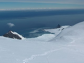
Bransfield Strait or Fleet Sea is a body of water about 100 kilometres (60 mi) wide extending for 300 miles (500 km) in a general northeast – southwest direction between the South Shetland Islands and the Antarctic Peninsula.

The Juan de Fuca Ridge is a mid-ocean spreading center and divergent plate boundary located off the coast of the Pacific Northwest region of North America, named after Juan de Fuca. The ridge separates the Pacific Plate to the west and the Juan de Fuca Plate to the east. It runs generally northward, with a length of approximately 500 kilometres (310 mi). The ridge is a section of what remains from the larger Pacific-Farallon Ridge which used to be the primary spreading center of this region, driving the Farallon Plate underneath the North American Plate through the process of plate tectonics. Today, the Juan de Fuca Ridge pushes the Juan de Fuca Plate underneath the North American plate, forming the Cascadia Subduction Zone.

Bowie Seamount, or SG̱aan Ḵinghlas in the Haida language, is a large submarine volcano in the northeastern Pacific Ocean, located 180 km (110 mi) west of Haida Gwaii, British Columbia, Canada. The seamount is also known as Bowie Bank. The English name for the feature is after William Bowie of the United States Coast and Geodetic Survey.
Cobb Seamount is a seamount and guyot located 500 km (310 mi) west of Grays Harbor, Washington, United States. Cobb Seamount is one of the seamounts in the Cobb–Eickelberg Seamount chain, a chain of underwater volcanoes created by the Cobb hotspot that terminates near the coast of Alaska. It lies just west of the Cascadia subduction zone, and was discovered in August 1950 by the U.S. Fish and Wildlife Service fisheries research vessel R/V John N. Cobb. By 1967, over 927 km (576 mi) of soundings and dozens of samples from the seamount had been collected.

The Hawaiʻi hotspot is a volcanic hotspot located near the namesake Hawaiian Islands, in the northern Pacific Ocean. One of the best known and intensively studied hotspots in the world, the Hawaii plume is responsible for the creation of the Hawaiian–Emperor seamount chain, a 6,200-kilometer (3,900 mi) mostly undersea volcanic mountain range. Four of these volcanoes are active, two are dormant; more than 123 are extinct, most now preserved as atolls or seamounts. The chain extends from south of the island of Hawaiʻi to the edge of the Aleutian Trench, near the eastern coast of Russia.

The following outline is provided as an overview of and introduction to Oceanography.
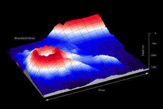
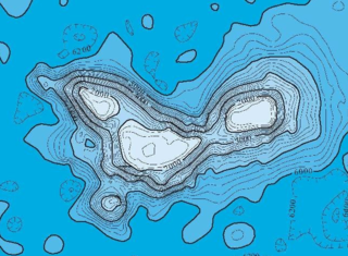
Orca Seamount is a seamount near King George Island in Antarctica, in the Bransfield Strait. While it is inactive, last volcanic activity at Orca Seamount is judged to have occurred in the recent past as there are temperature anomalies in the seawater around the seamount. Thermophilic and hyperthermophilic microorganisms have been found at the seamount.

Wōdejebato is a Cretaceous guyot or tablemount in the northern Marshall Islands, Pacific Ocean. Wōdejebato is probably a shield volcano and is connected through a submarine ridge to the smaller Pikinni Atoll 74 kilometres (46 mi) southeast of the guyot; unlike Wōdejebato, Pikinni rises above sea level. The seamount rises for 4,420 metres (14,500 ft) to 1,335 metres (4,380 ft) depth and is formed by basaltic rocks. The name Wōdejebato refers to a sea god of Pikinni.

Limalok is a Cretaceous-Paleocene guyot/tablemount in the southeastern Marshall Islands, one of a number of seamounts in the Pacific Ocean. It was probably formed by a volcanic hotspot in present-day French Polynesia. Limalok lies southeast of Mili Atoll and Knox Atoll, which rise above sea level, and is joined to each of them through a volcanic ridge. It is located at a depth of 1,255 metres (4,117 ft) and has a summit platform with an area of 636 square kilometres (246 sq mi).
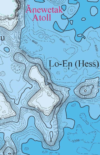
Lo-En or Hess is an Albian–Campanian guyot in the Marshall Islands. One among a number of seamounts in the Pacific Ocean, it was probably formed by a hotspot in what is present-day French Polynesia. Lo-En lies southeast of Eniwetok which rises above sea level, and Lo-En is almost connected to it through a ridge.
Ioah Guyot is a seamount in the Pacific Ocean, close to the Marshall Islands. Part of the Magellan Seamounts, it is a shield volcano that has erupted alkali basalt and hawaiite 87 million years ago, but may have continued erupting into the Miocene. During the Cretaceous, reefs developed on the guyot.

Horizon Guyot is a presumably Cretaceous guyot (tablemount) in the Mid-Pacific Mountains, Pacific Ocean. It is an elongated ridge, over 300 kilometres (190 mi) long and 4.3 kilometres (2.7 mi) high, that stretches in a northeast–southwest direction and has two flat tops; it rises to a minimum depth of 1,443 metres (4,730 ft). The Mid-Pacific Mountains lie west of Hawaii and northeast of the Line Islands.