A seamount is a mountain rising from the ocean seafloor that does not reach to the water's surface, and thus is not an island, islet or cliff-rock. Seamounts are typically formed from extinct volcanoes that rise abruptly and are usually found rising from the seafloor to 1,000–4,000 m (3,300–13,100 ft) in height. They are defined by oceanographers as independent features that rise to at least 1,000 m (3,281 ft) above the seafloor, characteristically of conical form. The peaks are often found hundreds to thousands of meters below the surface, and are therefore considered to be within the deep sea. During their evolution over geologic time, the largest seamounts may reach the sea surface where wave action erodes the summit to form a flat surface. After they have subsided and sunk below the sea surface such flat-top seamounts are called "guyots" or "tablemounts"

Baron Adrien Victor Joseph de Gerlache de Gomery was an officer in the Belgian Royal Navy who led the Belgian Antarctic Expedition of 1897–99.

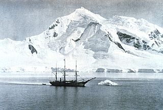
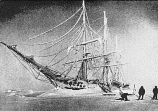
The Belgian Antarctic Expedition (BelgAE) of 1897 to 1899 was the first expedition to winter in the Antarctic region.

Gerlache Strait or de Gerlache Strait or Détroit de la Belgica is a channel/strait separating the Palmer Archipelago from the Antarctic Peninsula. The Belgian Antarctic Expedition, under Lt. Adrien de Gerlache, explored the strait in January and February 1898, naming it for the expedition ship Belgica. The name was later changed to honor the commander himself.

Bransfield Strait is a body of water about 100 kilometres (60 mi) wide extending for 300 miles (500 km) in a general northeast – southwest direction between the South Shetland Islands and the Antarctic Peninsula.

The Danco Coast is that portion of the west coast of the Antarctic Peninsula between Cape Sterneck and Cape Renard. This coast was explored in January and February 1898 by the Belgian Antarctic Expedition under Adrien de Gerlache, who named it for Lieutenant Emile Danco who died on the expedition.

Archer Glacier is a glacier flowing northwest into the head of Bolson Cove, Flandres Bay, on the west coast of Graham Land. It was first charted by the Belgian Antarctic Expedition under Adrien de Gerlache, 1897–99, and named by the United Kingdom Antarctic Place-Names Committee in 1960 for Frederick Scott Archer, an English architect who in 1849 invented the wet collodion process of photography, the first practical process on glass.

Belgica Glacier is a glacier 8 nautical miles (15 km) long, flowing into Trooz Glacier to the east of Lancaster Hill on Kiev Peninsula, on the west coast of Graham Land. It was first charted by the British Graham Land Expedition under John Rymill, 1934–37, and named by the UK Antarctic Place-Names Committee in 1959 after the RV Belgica, the ship of the Belgian Antarctic Expedition under Gerlache which explored this area in 1897–99.

Cape Cloos is a high rock cape fronting on Lemaire Channel and marking the north side of the entrance to Girard Bay on Kiev Peninsula, on the west coast of Graham Land. It was discovered by the Belgian Antarctic Expedition, 1897–99, under Gerlache, and named after M. Cloos, sometime Honorary Consul in Denmark.

Cape Pérez is a prominent cape between Collins Bay and Beascochea Bay on Kiev Peninsula, the west coast of Graham Land. It was discovered by the Belgian Antarctic Expedition, 1897–99, under Adrien de Gerlache, but apparently not named by them until about 1904, when in working up their scientific reports they gave it the name Trooz. In the meantime, Charcot's French Antarctic Expedition, 1903–05, left for the Antarctic and in November 1904 resighted the same cape, to which they gave the name Trois Pérez, for the brothers Fernando, Leopoldo and Manuel Pérez of Buenos Aires. Maurice Bongrain in his report of 1914 acknowledges the Belgian name Trooz for this cape. However, the Advisory Committee on Antarctic Names has retained the Charcot name because of wider usage, and has given the name Trooz to the large glacier 5 nautical miles (9.3 km) northeast of Cape Pérez.
Duseberg Buttress is a conspicuous rocky cone, 500 metres (1,600 ft) high, standing at the southwest side of Mount Scott on the west coast of Graham Land, Antarctica. It was discovered by the Belgian Antarctic Expedition, 1897–99, and named "Cap Duseberg" by Gerlache. Aerial photos show no cape, only a rock buttress, evidently the feature Gerlache intended to name.

Gerlache Island is the largest of the Rosenthal Islands lying off Gerlache Point on the west coast of Anvers Island, in the Palmer Archipelago of Antarctica. It was first roughly charted and named "Pointe de Gerlache" by the French Antarctic Expedition, 1903–05, under Jean-Baptiste Charcot, for Lieutenant Adrien de Gerlache. As a result of surveys by the Falkland Islands Dependencies Survey in 1956–58, this island is considered to be the feature named by Charcot; there is no prominent point in this vicinity which would be visible from seaward.
Cape Gerlache is a cape which forms the northeast tip of Davis Peninsula, Antarctica, 4 nautical miles (7 km) southeast of David Island. It was discovered in November 1912 by the Australasian Antarctic Expedition, 1911–14, under Mawson, who named it for Lieutenant Adrien de Gerlache, leader of the Belgian Antarctic Expedition, 1897–99.
Goodwin Glacier is a glacier flowing west into Flandres Bay southward of Pelletan Point on the west coast of Graham Land, Antarctica. It was charted by the Belgian Antarctic Expedition under Gerlache, 1897–99. It was named by the UK Antarctic Place-Names Committee in 1960 for Hannibal Goodwin, an American pastor who invented the first transparent nitrocellulose flexible photographic roll-film in 1887.
Metchnikoff Point is a point forming the western extremity of Pasteur Peninsula in northern Brabant Island, in the Palmer Archipelago, Antarctica. It was first charted by the Third French Antarctic Expedition, 1903–05, and named by Jean-Baptiste Charcot for Russian-born zoologist and bacteriologist Élie Metchnikoff, who succeeded Louis Pasteur as the director of the Pasteur Institute in Paris.
Sayce Glacier is a glacier flowing into Flandres Bay immediately north of Pelletan Point, on the west coast of Graham Land. Charted by the Belgian Antarctic Expedition under Gerlache, 1897-99. Named by the United Kingdom Antarctic Place-Names Committee (UK-APC) in 1960 for B.J. Sayce (1839–1895), English photographer who, with W.B. Bolton, invented the collodion emulsion process of dry plate photography, which displaced wet collodion in 1864.
Schollaert Channel is a channel between Anvers Island on the southwest and Brabant Island on the northeast, connecting Dallmann Bay and Gerlache Strait, in the Palmer Archipelago. Discovered in 1898 by the Belgian Antarctic Expedition under Gerlache, who named it for Frans Schollaert (1851–1917), Belgian statesman.

Hotine Glacier is a glacier 10 nautical miles (19 km) long which is divided at its mouth by Mount Cloos, flowing west into both Deloncle Bay and Girard Bay on Kiev Peninsula, on the west coast of Graham Land, Antarctica. It was first charted by the Belgian Antarctic Expedition under Gerlache, 1897–99, and was named by the UK Antarctic Place-Names Committee in 1959 for Brigadier Martin Hotine, Director of Overseas Surveys.
Gerlache or Gerlach may refer to:


