Flat topped seamount in the Hawaiian-Emperor seamount chain
Nintoku Seamount
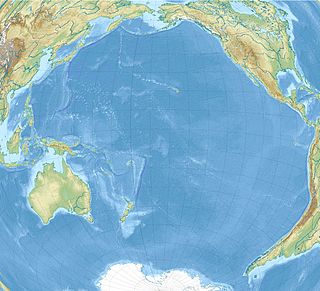
Elevation of the Pacific seafloor, showing the Hawaiian-Emperor seamount chain, including Nintoku Seamount near the center of the "V". The sharp "V" separates the Hawaiian Ridge from the older Emperor Seamount portion of the chain.
Nintoku Seamount or Nintoku Guyot is a seamount (underwater volcano) and guyot (flat top) in the Hawaiian-Emperor seamount chain. It is a large, irregularly shaped volcano that last erupted 66 million years ago. Three lava flows have been sampled at Nintoku Seamount; the flows are almost all alkalic (subaerial) lava.[4] It is 56.2 million years old.[3]
Nintoku is positioned a roughly 41 degrees north latitude, approximately two-thirds the way southward along the north-northeast-south-southeast Emperor seamounts extending from Meiji Seamount (about 53°N) in the north to Kammu Seamount (about 32°N) at the chain's southern terminus. Nintoku Seamount was named after the 16th emperor of Japan, Emperor Nintoku, by geologist Robert Dietz in 1954.[4]
The seamount occupies a central position in the Emperor Seamount chain and is thus an important point in the paleolatitude history of the Hawaiian hotspot, instrumental to proving the scientific hunch that the Hawaii hotspot was a mobile entity.[1] The structure of the seamount is elongate, aligned north-northwest along the Emperor trend, with two prominent ridges trending southwest and south-southwest as far as 100km (62mi) from the main crater. Nintoku Seamount is a plexus of coalesced volcanoes, much like many of the larger seamounts in this chain. The Nintoku system is, however, clearly isolated from Yomei Seamount, about 100km (62mi) to the north, and Jingu Seamount, about 200km (124mi) to south, by abyssal depths.[1]
Geology and characteristics
In seismic profile, the main body of the seamount rises steeply over 5,000m (16,404ft) in predominantly unsedimented volcanic slope to the thinly sedimented (10m (33ft) to 200m (660ft)), from an Emperor point of view, gently domed summit region between 1,200m (3,937ft) to 1,400m (4,593ft) high peak profile, which covers about 3400 square kilometers of area.[1]
From analysis of seismic reflection survey data and core material recovered by drillings at Site 432, the shipboard party of Deep Sea Drilling Project (DSDP) Leg 55 proposed that Nintoku Seamount was in an intermediate atoll stage (no lagoon but fringing reefs and banks and extensive carbonate bank interiors) before subsidence removed the island below the wave base. It was further thought that a few small remnant volcanic peaks and domes still pierce the sedimentary deposits.[1]
Nintoku Seamount apparently remained at or above sea level long enough to be almost completely devastated by subaerial erosion and wave action. Reefs were not indicated in the seismic studies, but fragmented pieces of coral were recovered and documented, showing a shallow-water sediment-rich condition. The rock records indicate deposition in waters cooler than the present tropical condition. Shallow-water sedimentary deposition ceased in Paleogene times.[1]
The seamount was first drilled by Site 432, located on the northwestern edge of the summit region of Nintoku Seamount, in a gently sloping area mapped as terrace deposits. Although the sediment cover was estimated, based on other seamount covers, to be 80m (262ft) thick, bedrock was hit after only 42m (138ft). Poorly recovered and preserved sedimentary deposits indicated a shallow-reef bed typical of terraced flanking reefs and banks, as well as volcanic sand. Drilling at Site 432 penetrated 32m (105ft) of volcanic rock (74m (243ft) total) before terminating because of hole caving and damage to the drill assembly.[1]
The site was drilled as part of Leg 197 by the Ocean Drilling Program, at site number 1205.[4] A short bathymetric acoustic survey was conducted to find the best site for the location and structure of a core sampling. The locale chosen was about 100m (328ft) southwest of Site 432, the location of a previous drilling by the ODP.
Site 1205 (41°20.00′N170°22.70′E / 41.33333°N 170.37833°E / 41.33333; 170.37833)[1] was located in 1,310-metre-deep (4,298ft) water, where previous drilling had reached volcanic rock beneath Paleocene deposits. It was elected to return to the site for a number of reasons. First, drilling at the nearby site 432 had hit reasonably unaltered and unchanged basalt with good remnant magnetic properties, key to finding the latitude of origin; but insufficient sampling caused a lack of data, and determining the age accurately was not possible. Hence, deeper drilling was promised to achieve that goal, providing a time-averaged (as the seamount is in the center of the chain) movement ratio.[1] Second, a survey of the region showed a rock structure suitable for deep drilling, and nearby sites met low levels of sedimentary cover. Thirdly, the composition of previously drilled volcanic rock seemed to match the volcano's "average" type, erupted during the post-shield stage of it life. This helped another project goal, to recover a suitable and datable chunk of tholeiitic lava, which appeared to be rare on the seamount.[1]
The hole was drilled in what appeared to be a large, broad sedimentary cover (estimated 70m (230ft) in thickness) covering a swath of the ancient volcano's main slope.[4] The coring encountered volcanic rock at 42m (138ft) below the sea floor, and continued to a final depth of 326m (1,070ft) below the sea floor. The sedimentary cover, an element commonly found on many of the Emperor seamounts, was found to be largely a stack interlaced lava flows (about 95%). The drilling penetrated 283m (928ft) into the seamount's volcanic rock, and recovered at least 25 different hardened lava flows.[4]
It was established that Nintoku Seamount's sedimentary cap consists of sandstone and siltstone containing well-rounded to subrounded basalt blocks, volcanic ash, fossil fragments of mollusks, benthic foraminifers, bryozoans, and corallinered algae. These observations indicate a shallow-water, high-rate depositional setting. Little variation was found in the density, grain size, or porosity of the volcanic rock, and it was stable in composition, except for the volcanic-sedimentary cover. It is believed that this is the underlying cause of aucousically recorded layering of the upper 200m (656ft)-230m (755ft) of rock, after which the effect of soil layering fades away.[4]
The age of the youngest volcanic rocks was constrained by nano-fossils in the sediment to be older than 53.6–54.7 million years, an age that is just younger than the radiometric age of 56.2 ± 0.6 million obtained for the basalt drilled from nearby Hole 432A.[4] The thickness and vesicularity of the lava flows, as well as the presence of oxidized flow tops and soil horizons and a lack of pillow lava, indicate that all of the obtained samples erupted subaerially. The volcanic rock ranges from aphyric to highly plagioclase and olivine-phyric basalt. At 230 to 255 meters below ground, two flows of tholeiitic basalt were found interlaced with the alkalic basalt flows. Above these flows the degree of alkalinity skyrockets.[4] There is evidence suggesting that the eruption rates must have been lower at the period during which the two flows were deposited, which is consistent with the model of Hawaiian volcanic growth, which increases in activity slowly over time before ceasing altogether. Internal lava flows have also created course-grained rocks.[4] Lavas from Nintoku Seamount have similar composition to lava erupted during the post-shield stage of Hawaiian volcanoes such as Mauna Kea. Slight differences in trace element composition between lavas from Nintoku Seamount and active Hawaiian volcanoes probably result from differences in source composition or variations in the degree of melting.[4]
All of the recovered lava flows had been altered very little by erosion or other lava flows, except for thin flow tops. Sparse veining indicates that there is only small-scale fluid circulation within the rocks, in contrast with some of the data collected from Detroit Seamount.[4]
Rock magnetic data obtained suggest that the lava flows from Site 1205 carry a remnant magnetization suitable for scientific analysis. Although some of the rocks needed a more complex and thorough analysis, most samples yielded data suitable to make a preliminary determination of magnetic inclinations. Twenty-two independent magnetic group were identified, yielding a mean inclination of -45.7° (+10.5°/-6.3°). The mean inclination suggests a latitude of formation on an early Eocene Nintoku Seamount at 27.1° (+5.5°/-7.7°).[4] This value, together with paleo-latitudes from analyses of rocks at Site 433 (1980), Site 884 (1997), and Sites 1203 and 1204 (Leg 197; Detroit Seamount), form a consistent data set indicating southward motion of the Hawaiian hotspot from Late Cretaceous to early Tertiary time, a hunch that many scientists had harbored for a long time.[4]
A seamount is a large geologic landform that rises from the ocean floor but that does not reach to the water's surface, and thus is not an island, islet or cliff-rock. Seamounts are typically formed from extinct volcanoes that rise abruptly and are usually found rising from the seafloor to 1,000–4,000 m (3,300–13,100 ft) in height. They are defined by oceanographers as independent features that rise to at least 1,000 m (3,281 ft) above the seafloor, characteristically of conical form. The peaks are often found hundreds to thousands of meters below the surface, and are therefore considered to be within the deep sea. During their evolution over geologic time, the largest seamounts may reach the sea surface where wave action erodes the summit to form a flat surface. After they have subsided and sunk below the sea surface such flat-top seamounts are called "guyots" or "tablemounts".
A shield volcano is a type of volcano named for its low profile, resembling a warrior's shield lying on the ground. It is formed by the eruption of highly fluid lava, which travels further and forms thinner flows than the more viscous lava erupted from a stratovolcano. Repeated eruptions results in the steady accumulation of broad sheets of lava, building up the shield volcano's distinctive form.
The fifteen volcanoes that make up the eight principal islands of Hawaii are the youngest in a chain of more than 129 volcanoes that stretch 5,800 kilometres (3,600 mi) across the North Pacific Ocean, called the Hawaiian–Emperor seamount chain. Hawaiʻi's volcanoes rise an average of 4,600 metres (15,000 ft) to reach sea level from their base. The largest, Mauna Loa, is 4,169 metres (13,678 ft) high. As shield volcanoes, they are built by accumulated lava flows, growing a few meters or feet at a time to form a broad and gently sloping shape.
Several types of volcanic eruptions—during which lava, tephra, and assorted gases are expelled from a volcanic vent or fissure—have been distinguished by volcanologists. These are often named after famous volcanoes where that type of behavior has been observed. Some volcanoes may exhibit only one characteristic type of eruption during a period of activity, while others may display an entire sequence of types all in one eruptive series.
Meiji Seamount, named after Emperor Meiji, the 122nd Emperor of Japan, is the oldest seamount in the Hawaiian-Emperor seamount chain, with an estimated age of 82 million years. It lies at the northernmost end of the chain, and is perched at the outer slope of the Kuril–Kamchatka Trench. Like the rest of the Emperor seamounts, it was formed by the Hawaii hotspot volcanism, grew to become an island, and has since subsided to below sea level, all while being carried first north and now northwest by the motion of the Pacific Plate. Meiji Seamount is thus an example of a particular type of seamount known as a guyot, and some publications refer to it as Meiji Guyot.
The Hawai’i hotspot is a volcanic hotspot located near the namesake Hawaiian Islands, in the northern Pacific Ocean. One of the best known and intensively studied hotspots in the world, the Hawaii plume is responsible for the creation of the Hawaiian–Emperor seamount chain, a 6,200-kilometer (3,900 mi) mostly undersea volcanic mountain range. Four of these volcanoes are active, two are dormant; more than 123 are extinct, most now preserved as atolls or seamounts. The chain extends from south of the island of Hawaiʻi to the edge of the Aleutian Trench, near the eastern coast of Russia.
Detroit Seamount, which was formed around 76 million years ago, is one of the oldest seamounts of the Hawaiian-Emperor seamount chain. It lies near the northernmost end of the chain and is south of Aleutian Islands, at 51°28.80′N167°36′E It is a seamount in the chain, located north of the hinge of the "V" in the image at right.
Pilot Knob is the eroded core of an extinct volcano located 8 miles (13 km) south of central Austin, Texas, near Austin-Bergstrom International Airport and McKinney Falls State Park.
Koko Guyot is a 48.1-million-year-old guyot, a type of underwater volcano with a flat top, which lies near the southern end of the Emperor seamounts, about 200 km (124 mi) north of the "bend" in the volcanic Hawaiian-Emperor seamount chain. Pillow lava has been sampled on the north west flank of Koko Seamount, and the oldest dated lava is 40 million years old. Seismic studies indicate that it is built on a 9 km (6 mi) thick portion of the Pacific Plate. The oldest rock from the north side of Koko Seamount is dated at 52.6 and the south side of Koko at 50.4 million years ago. To the southeast of the bend is Kimmei Seamount at 47.9 million years ago and southeast of it, Daikakuji at 46.7.
The volcanology of Eastern Canada includes the hundreds of volcanic areas and extensive lava formations in Eastern Canada. The region's different volcano and lava types originate from different tectonic settings and types of volcanic eruptions, ranging from passive lava eruptions to violent explosive eruptions. Eastern Canada has very large volumes of magmatic rock called large igneous provinces. They are represented by deep-level plumbing systems consisting of giant dike swarms, sill provinces and layered intrusions. The most capable large igneous provinces in Eastern Canada are Archean age greenstone belts containing a rare volcanic rock called komatiite.
Rodriguez Seamount is a seamount and guyot located about 150 km (93 mi) off the coast of Central California. It is structurally similar to the nearby Guide, Pioneer, Gumdrop, and Davidson seamounts, all located roughly between 37.5° and 34.0° degrees of latitude. This group of seamounts is morphologically unique, and the mounts are very similar to one another. The seamount structures run parallel to an ancient spreading center which has since been replaced in its role by the San Andreas Fault system.
The Canadian Cascade Arc, also called the Canadian Cascades, is the Canadian segment of the North American Cascade Volcanic Arc. Located entirely within the Canadian province of British Columbia, it extends from the Cascade Mountains in the south to the Coast Mountains in the north. Specifically, the southern end of the Canadian Cascades begin at the Canada–United States border. However, the specific boundaries of the northern end are not precisely known and the geology in this part of the volcanic arc is poorly understood. It is widely accepted by geologists that the Canadian Cascade Arc extends through the Pacific Ranges of the Coast Mountains. However, others have expressed concern that the volcanic arc possibly extends further north into the Kitimat Ranges, another subdivision of the Coast Mountains, and even as far north as Haida Gwaii.
Wōdejebato is a Cretaceous guyot or tablemount in the northern Marshall Islands, Pacific Ocean. Wōdejebato is probably a shield volcano and is connected through a submarine ridge to the smaller Pikinni Atoll 74 kilometres (46 mi) southeast of the guyot; unlike Wōdejebato, Pikinni rises above sea level. The seamount rises for 4,420 metres (14,500 ft) to 1,335 metres (4,380 ft) depth and is formed by basaltic rocks. The name Wōdejebato refers to a sea god of Pikinni.
Limalok is a Cretaceous-Paleocene guyot/tablemount in the southeastern Marshall Islands, one of a number of seamounts in the Pacific Ocean. It was probably formed by a volcanic hotspot in present-day French Polynesia. Limalok lies southeast of Mili Atoll and Knox Atoll, which rise above sea level, and is joined to each of them through a volcanic ridge. It is located at a depth of 1,255 metres (4,117 ft) and has a summit platform with an area of 636 square kilometres (246 sq mi).
Lo-En or Hess is an Albian–Campanian guyot in the Marshall Islands. One among a number of seamounts in the Pacific Ocean, it was probably formed by a hotspot in what is present-day French Polynesia. Lo-En lies southeast of Eniwetok which rises above sea level, and Lo-En is almost connected to it through a ridge.
Ita Mai Tai is a Cretaceous-early Cenozoic seamount northwest of the Marshall Islands and north of Micronesia. One among a number of seamounts in the Pacific Ocean, it is part of the Magellan Seamounts which may have a hotspot origin although Ita Mai Tai itself may not have formed on a hotspot.
Resolution Guyot is a guyot (tablemount) in the underwater Mid-Pacific Mountains in the Pacific Ocean. It is a circular flat mountain, rising 500 metres (1,600 ft) above the seafloor to a depth of about 1,320 metres (4,330 ft), with a 35 kilometres (22 mi) wide summit platform. The Mid-Pacific Mountains lie west of Hawaii and northeast of the Marshall Islands, but at the time of its formation the guyot was located in the Southern Hemisphere.
Horizon Guyot is a presumably Cretaceous guyot (tablemount) in the Mid-Pacific Mountains, Pacific Ocean. It is an elongated ridge, over 300 kilometres (190 mi) long and 4.3 kilometres (2.7 mi) high, that stretches in a northeast-southwest direction and has two flat tops; it rises to a minimum depth of 1,443 metres (4,730 ft). The Mid-Pacific Mountains lie west of Hawaii and northeast of the Line Islands.
South Arch volcanic field is an underwater volcanic field south of Hawaiʻi Island. It was active during the last 10,000 years, and covers an area of 35 by 50 kilometres at a depth of 4,950 metres (16,240 ft).
North Arch volcanic field is an underwater volcanic field north of Oahu, Hawaii. It covers an area of about 25,000 square kilometres (9,700 sq mi) and consists of large expanses of alkali basalt, basanite and nephelinite that form extensive lava flows and volcanic cones. Some lava flows are longer than 100 kilometres (62 mi).
This page is based on this Wikipedia article Text is available under the CC BY-SA 4.0 license; additional terms may apply. Images, videos and audio are available under their respective licenses.