The Iceland hotspot is a hotspot which is partly responsible for the high volcanic activity which has formed the Iceland Plateau and the island of Iceland. It contributes to understanding the geological deformation of Iceland.

The Kerguelen hotspot is a volcanic hotspot at the Kerguelen Plateau in the Southern Indian Ocean. The Kerguelen hotspot has produced basaltic lava for about 130 million years and has also produced the Kerguelen Islands, Naturaliste Plateau, Heard Island, the McDonald Islands, the Comei large igneous province in south Tibet, and the Rajmahal Traps. One of the associated features, the Ninety East Ridge, is distinguished by its over 5,000 km (3,100 mi) length, being the longest linear tectonic feature on Earth. The total volume of magma erupted in 130 million years with associated features has been estimated to be about 25,000,000 km3 (6,000,000 cu mi). However, as well as large igneous provinces and seamounts the hotspot has interacted with other seafloor spreading features, so this volume figure has some uncertainty.

The New England hotspot, also referred to as the Great Meteor hotspot and sometimes the Monteregian hotspot, is a volcanic hotspot in the North Atlantic Ocean. It created the Monteregian Hills intrusions in Montreal and Montérégie, the White Mountains intrusions in New Hampshire, the New England and Corner Rise seamounts off the coast of North America, and the Seewarte Seamounts east of the Mid-Atlantic Ridge on the African Plate, the latter of which include its most recent eruptive center, the Great Meteor Seamount. The New England, Great Meteor, or Monteregian hotspot track has been used to estimate the movement of the North American Plate away from the African Plate from the early Cretaceous period to the present using the fixed hotspot reference frame.

The Hawaiʻi hotspot is a volcanic hotspot located near the namesake Hawaiian Islands, in the northern Pacific Ocean. One of the best known and intensively studied hotspots in the world, the Hawaii plume is responsible for the creation of the Hawaiian–Emperor seamount chain, a 6,200-kilometer (3,900 mi) mostly undersea volcanic mountain range. Four of these volcanoes are active, two are dormant; more than 123 are extinct, most now preserved as atolls or seamounts. The chain extends from south of the island of Hawaiʻi to the edge of the Aleutian Trench, near the eastern coast of Russia.
The Boomerang Seamount is an active submarine volcano, located 18 km (11 mi) northeast of Amsterdam Island, France. It was formed by the Amsterdam-Saint Paul hotspot and has a 2 km (1.2 mi) wide caldera that is 200 m (660 ft) deep. Hydrothermal activity occurs within the caldera. The sampled rocks are basalt and picrite basalt.

The Southwest Indian Ridge (SWIR) is a mid-ocean ridge located along the floors of the south-west Indian Ocean and south-east Atlantic Ocean. A divergent tectonic plate boundary separating the Somali plate to the north from the Antarctic plate to the south, the SWIR is characterised by ultra-slow spreading rates (only exceeding those of the Gakkel Ridge in the Arctic) combined with a fast lengthening of its axis between the two flanking triple junctions, Rodrigues (20°30′S70°00′E) in the Indian Ocean and Bouvet (54°17′S1°5′W) in the Atlantic Ocean.

The Southeast Indian Ridge (SEIR) is a mid-ocean ridge in the southern Indian Ocean. A divergent tectonic plate boundary stretching almost 6,000 km (3,700 mi) between the Rodrigues triple junction in the Indian Ocean and the Macquarie triple junction in the Pacific Ocean, the SEIR forms the plate boundary between the Australian and Antarctic plates since the Oligocene (anomaly 13).

The Tristan hotspot is a volcanic hotspot which is responsible for the volcanic activity which forms the volcanoes in the southern Atlantic Ocean. It is thought to have formed the island of Tristan da Cunha and the Walvis Ridge on the African Plate.

The Samoa hotspot is a volcanic hotspot located in the south Pacific Ocean. The hotspot model describes a hot upwelling plume of magma through the Earth's crust as an explanation of how volcanic islands are formed. The hotspot idea came from J. Tuzo Wilson in 1963 based on the Hawaiian Islands volcanic chain.

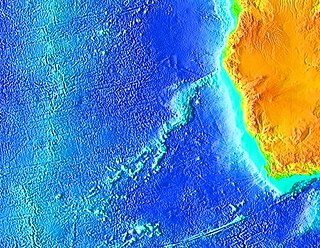
The Walvis Ridge is an aseismic ocean ridge in the southern Atlantic Ocean. More than 3,000 km (1,900 mi) in length, it extends from the Mid-Atlantic Ridge, near Tristan da Cunha and the Gough Islands, to the African coast. The Walvis Ridge is one of few examples of a hotspot seamount chain that links a flood basalt province to an active hotspot. It is also considered one of the most important hotspot tracks because the Tristan Hotspot is one of few primary or deep mantle hotspots.

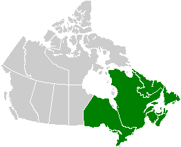
The volcanism of Eastern Canada includes the hundreds of volcanic areas and extensive lava formations in Eastern Canada. The region's different volcano and lava types originate from different tectonic settings and types of volcanic eruptions, ranging from passive lava eruptions to violent explosive eruptions. Eastern Canada has very large volumes of magmatic rock called large igneous provinces. They are represented by deep-level plumbing systems consisting of giant dike swarms, sill provinces and layered intrusions. The most capable large igneous provinces in Eastern Canada are Archean age greenstone belts containing a rare volcanic rock called komatiite.

Ocean island basalt (OIB) is a volcanic rock, usually basaltic in composition, erupted in oceans away from tectonic plate boundaries. Although ocean island basaltic magma is mainly erupted as basalt lava, the basaltic magma is sometimes modified by igneous differentiation to produce a range of other volcanic rock types, for example, rhyolite in Iceland, and phonolite and trachyte at the intraplate volcano Fernando de Noronha. Unlike mid-ocean ridge basalts (MORBs), which erupt at spreading centers (divergent plate boundaries), and volcanic arc lavas, which erupt at subduction zones (convergent plate boundaries), ocean island basalts are the result of intraplate volcanism. However, some ocean island basalt locations coincide with plate boundaries like Iceland, which sits on top of a mid-ocean ridge, and Samoa, which is located near a subduction zone.

The Shona or Meteor hotspot is a volcanic hotspot located in the southern Atlantic Ocean. Its zig-zag-shaped hotspot track, a chain of seamounts and ridges, stretches from its current location at or near the southern end of the Mid-Atlantic Ridge to South Africa.
Foundation Seamounts are a series of seamounts in the southern Pacific Ocean. Discovered in 1992, these seamounts form a 1,350 kilometres (840 mi) long chain which starts from the Pacific-Antarctic Ridge. Some of these seamounts may have once emerged from the ocean.

Musicians Seamounts are a chain of seamounts in the Pacific Ocean, north of the Hawaiian Ridge. There are about 65 seamounts, some of which are named after musicians. These seamounts exist in two chains, one of which has been attributed to a probably now-extinct hotspot called the Euterpe hotspot. Others may have formed in response to plate tectonics associated with the boundary between the Pacific plate and the former Farallon plate.
The Discovery Seamounts are a chain of seamounts in the Southern Atlantic Ocean, including Discovery Seamount. The seamounts are 850 kilometres (530 mi) east of Gough Island and once formed islands. Various volcanic rocks as well as glacial dropstones and sediments have been dredged from the Discovery Seamounts.
Tropic Seamount is a Cretaceous seamount, part of the Canary Islands Seamount Province. It is located west of the Morocco's coastline and southwest of the Canary Islands, north of Cape Verde. It is one of a number of seamounts in this part of the Atlantic Ocean, probably formed by volcanic processes triggered by the proximity to the African continent. Tropic Seamount is located at a depth of 970 metres (3,180 ft) and has a summit platform with an area of 120 square kilometres (46 sq mi).

Krylov Seamount is a volcanic seamount in the Atlantic Ocean, west of the Cape Verde islands. It is formed by one seamount and one ridge which are separated by a 5 kilometres (3.1 mi) wide depression, and it rises to a minimum depth of 1,240 metres (4,070 ft); formerly the depression was interpreted to be a caldera. The seamount probably formed no later than 70-75 million years ago before sinking to its current depth.
Sierra Leone hotspot is a proposed hotspot in the Atlantic Ocean.
Intraplate volcanism is volcanism that takes place away from the margins of tectonic plates. Most volcanic activity takes place on plate margins, and there is broad consensus among geologists that this activity is explained well by the theory of plate tectonics. However, the origins of volcanic activity within plates remains controversial.


