Related Research Articles

The Hawaiian–Emperor seamount chain is a mostly undersea mountain range in the Pacific Ocean that reaches above sea level in Hawaii. It is composed of the Hawaiian ridge, consisting of the islands of the Hawaiian chain northwest to Kure Atoll, and the Emperor Seamounts: together they form a vast underwater mountain region of islands and intervening seamounts, atolls, shallows, banks and reefs along a line trending southeast to northwest beneath the northern Pacific Ocean. The seamount chain, containing over 80 identified undersea volcanoes, stretches about 6,200 km (3,900 mi) from the Aleutian Trench in the far northwest Pacific to the Kamaʻehuakanaloa Seamount, the youngest volcano in the chain, which lies about 35 kilometres (22 mi) southeast of the Island of Hawaiʻi.
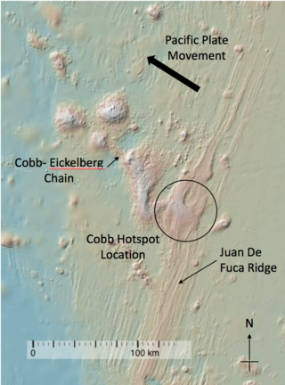
The Cobb hotspot is a marine volcanic hotspot at, which is 460 km (290 mi) west of Oregon and Washington, North America, in the Pacific Ocean. Over geologic time, the Earth's surface has migrated with respect to the hotspot through plate tectonics, creating the Cobb–Eickelberg Seamount chain. The hotspot is currently collocated with the Juan de Fuca Ridge.
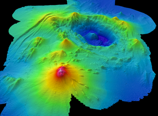
Axial Seamount is a seamount, submarine volcano, and underwater shield volcano in the Pacific Ocean, located on the Juan de Fuca Ridge, approximately 480 km (298 mi) west of Cannon Beach, Oregon. Standing 1,100 m (3,609 ft) high, Axial Seamount is the youngest volcano and current eruptive center of the Cobb–Eickelberg Seamount chain. Located at the center of both a geological hotspot and a mid-ocean ridge, the seamount is geologically complex, and its origins are still poorly understood. Axial Seamount is set on a long, low-lying plateau, with two large rift zones trending 50 km (31 mi) to the northeast and southwest of its center. The volcano features an unusual rectangular caldera, and its flanks are pockmarked by fissures, vents, sheet flows, and pit craters up to 100 m (328 ft) deep; its geology is further complicated by its intersection with several smaller seamounts surrounding it.

The Hawaiʻi hotspot is a volcanic hotspot located near the namesake Hawaiian Islands, in the northern Pacific Ocean. One of the best known and intensively studied hotspots in the world, the Hawaii plume is responsible for the creation of the Hawaiian–Emperor seamount chain, a 6,200-kilometer (3,900 mi) mostly undersea volcanic mountain range. Four of these volcanoes are active, two are dormant; more than 123 are extinct, most now preserved as atolls or seamounts. The chain extends from south of the island of Hawaiʻi to the edge of the Aleutian Trench, near the eastern coast of Russia.

The Southeast Indian Ridge (SEIR) is a mid-ocean ridge in the southern Indian Ocean. A divergent tectonic plate boundary stretching almost 6,000 km (3,700 mi) between the Rodrigues Triple Junction in the Indian Ocean and the Macquarie Triple Junction in the Pacific Ocean, the SEIR forms the plate boundary between the Australian and Antarctic plates since the Oligocene (anomaly 13).

The Louisville Ridge, often now referred to as the Louisville Seamount Chain, is an underwater chain of over 70 seamounts located in the Southwest portion of the Pacific Ocean. As one of the longest seamount chains on Earth it stretches some 4,300 km (2,700 mi) from the Pacific-Antarctic Ridge northwest to the Tonga-Kermadec Trench, where it subducts under the Indo-Australian Plate as part of the Pacific Plate. The chains formation is best explained by movement of the Pacific Plate over the Louisville hotspot although others had suggested by leakage of magma from the shallow mantle up through the Eltanin fracture zone, which it follows closely for some of its course.

The Lau Basin is a back-arc basin at the Australian-Pacific plate boundary. It is formed by the Pacific plate subducting under the Australian plate. The Tonga-Kermadec Ridge, a frontal arc, and the Lau-Colville Ridge, a remnant arc, sit to the eastern and western sides of the basin, respectively. The basin has a raised transition area to the south where it joins the Havre Trough.

The Shatsky Rise is Earth's third largest oceanic plateau, located in the north-west Pacific Ocean 1,500 km (930 mi) east of Japan. It is one of a series of Pacific Cretaceous large igneous provinces (LIPs) together with Hess Rise, Magellan Rise, and Ontong Java-Manihiki-Hikurangi. It was named for Nikolay Shatsky (1895-1960), a Soviet geologist, expert in tectonics of ancient platforms.

The Pacific Ocean evolved in the Mesozoic from the Panthalassic Ocean, which had formed when Rodinia rifted apart around 750 Ma. The first ocean floor which is part of the current Pacific Plate began 160 Ma to the west of the central Pacific and subsequently developed into the largest oceanic plate on Earth.
Foundation Seamounts are a series of seamounts in the southern Pacific Ocean. Discovered in 1992, these seamounts form a 1,350 kilometres (840 mi) long chain which starts from the Pacific-Antarctic Ridge. Some of these seamounts may have once emerged from the ocean.
Macdonald seamount is a seamount in Polynesia, southeast of the Austral Islands and in the neighbourhood of a system of seamounts that include the Ngatemato seamounts and the Taukina seamounts. It rises 4,200 metres (13,800 ft) from the seafloor to a depth of about 40 metres (130 ft) and has a flat top, but the height of its top appears to vary with volcanic activity. There are some subsidiary cones such as Macdocald seamount. The seamount was discovered in 1967 and has been periodically active with gas release and seismic activity since then. There is hydrothermal activity on Macdonald, and the vents are populated by hyperthermophilic bacteria.

Musicians Seamounts are a chain of seamounts in the Pacific Ocean, north of the Hawaiian Ridge. There are about 65 seamounts, some of which are named after musicians. These seamounts exist in two chains, one of which has been attributed to a probably now-extinct hotspot called the Euterpe hotspot. Others may have formed in response to plate tectonics associated with the boundary between the Pacific Plate and the former Farallon Plate.
Discovery Seamounts are a chain of seamounts in the Southern Atlantic Ocean, which include the Discovery Seamount. The seamounts lie 850 kilometres (530 mi) east of Gough Island and once rose above sea level. Various volcanic rocks as well as glacial dropstones and sediments have been dredged from the seamounts.
Hollister Ridge is a group of seamounts in the Pacific Ocean. They lie west from the Pacific-Antarctic Ridge and form three ridges that form a line; one of the ridges rises to a depth of 100 metres (330 ft) and in the past formed an island. The seamounts are composed out of basaltic and other rocks and their ages range from about 2.5 million years ago to latest Pleistocene; an acoustic swarm recorded in the southern Pacific Ocean in 1991-1992 is considered to be the manifestation of a historical eruption of the Hollister Ridge.
Crough Seamount is a seamount in the Pacific Ocean, within the exclusive economic zone of Pitcairn. It rises to a depth of 650 metres (2,130 ft) and is paired with a taller but overall smaller seamount to the east. This seamount has a flat top and probably formed an island in the past. It is about 7-8 million years old, although a large earthquake recorded at its position in 1955 may indicate a recent eruption.

Vesteris Seamount, also known as Vesteris Bank, is a seamount in the Greenland Sea of the North Atlantic Ocean between Greenland and Norway. It lies north of Jan Mayen and rises from 41–43 million years old ocean crust. The reasons for the volcanic activity at Vesteris are unclear and may involve lithospheric processes.

The Rarotonga hotspot is a volcanic hotspot in the southern Pacific Ocean. The hotspot is claimed to be responsible for the formation of Rarotonga and some volcanics of Aitutaki but an alternative explanation for these islands most recent volcanics has not been ruled out. Recently alternatives to hotspot activity have been offered for several other intra-plate volcanoes that may have been associated with the Rarotonga hotspot hypothesis.
Monowai Seamount is a volcanic seamount to the north of New Zealand. It is formed by a large caldera and a volcanic cone just south-southeast from the caldera. The volcanic cone rises to depths of up to 100 metres (330 ft) but its depth varies with ongoing volcanic activity, including sector collapses and the growth of lava domes. The seamount and its volcanism were discovered after 1877, but only in 1980 was it named "Monowai" after a research ship of the same name.

Vailuluʻu is a volcanic seamount discovered in 1975. It rises from the sea floor to a depth of 593 m (1,946 ft) and is located between Taʻu and Rose islands at the eastern end of the Samoa hotspot chain. The basaltic seamount is considered to mark the current location of the Samoa hotspot. The summit of Vailuluʻu contains a 2 km wide, 400 m deep oval-shaped caldera. Two principal rift zones extend east and west from the summit, parallel to the trend of the Samoan hotspot. A third less prominent rift extends southeast of the summit.
South Arch volcanic field is an underwater volcanic field south of Hawaiʻi Island. It was active during the last 10,000 years, and covers an area of 35 by 50 kilometres at a depth of 4,950 metres (16,240 ft).
References
- 1 2 Hall et al. 2006, p. 2.
- ↑ Shimizu et al. 2023, p. 162.
- 1 2 3 4 Scheirer et al. 1996, p. 13.
- 1 2 3 Scheirer et al. 1996, p. 28.
- ↑ Scheirer et al. 1996, p. 18.
- ↑ Scheirer et al. 1996, p. 36.
- ↑ Scheirer et al. 1996, p. 16.
- ↑ Scheirer et al. 1996, p. 31.
- 1 2 Scheirer et al. 1996, p. 33.
- ↑ Hall et al. 2006, p. 13.
- ↑ Scheirer et al. 1996, p. 38.
- ↑ Hall et al. 2006, p. 3.
- ↑ Shimizu et al. 2023, p. 165.
- ↑ Scheirer et al. 1996, p. 40.
- ↑ Scheirer et al. 1996, p. 50.
- ↑ Shen, Yang; Scheirer, Daniel S.; Forsyth, Donald W.; Macdonald, Ken C. (1995). "Trade-off in production between adjacent seamount chains near the East Pacific Rise". Nature. 373 (6510): 140. Bibcode:1995Natur.373..140S. doi:10.1038/373140a0. ISSN 1476-4687. S2CID 4319189.
- ↑ Bell, Samuel; Ruan, Youyi; Forsyth, Donald W. (October 2016). "Ridge asymmetry and deep aqueous alteration at the trench observed from Rayleigh wave tomography of the Juan de Fuca plate". Journal of Geophysical Research: Solid Earth. 121 (10): 7311. Bibcode:2016JGRB..121.7298B. doi: 10.1002/2016JB012990 .
- ↑ Hall et al. 2006, p. 22.
- ↑ Weeraratne, D.S; Parmentier, E.M.; Forsyth, Forsyth, D.W. (2003). "Viscous Fingering of Miscible Fluids in Laboratory Experiments and the Oceanic Mantle Asthenosphere". AGU Fall Meeting Abstracts. 2003: V21B–03. Bibcode:2003AGUFM.V21B..03W.
{{cite journal}}: CS1 maint: multiple names: authors list (link) - ↑ Morgan, W. Jason; Morgan, Jason Phipps (2007). "Plate velocities in hotspot reference frame: electronic supplement". geosociety.org: 77. doi: 10.1130/2007090 .
- ↑ Kingsley, Richard H.; Blichert-Toft, Janne; Fontignie, Denis; Schilling, Jean-Guy (April 2007). "Hafnium, neodymium, and strontium isotope and parent-daughter element systematics in basalts from the plume-ridge interaction system of the Salas y Gomez Seamount Chain and Easter Microplate". Geochemistry, Geophysics, Geosystems. 8 (4): 25. Bibcode:2007GGG.....8.4005K. doi: 10.1029/2006GC001401 .
- ↑ Scheirer et al. 1996, p. 15.
- 1 2 Scheirer et al. 1996, p. 27.
- ↑ Scheirer et al. 1996, p. 29.
- ↑ Scheirer et al. 1996, p. 25.
Sources
- Hall, L. S.; Mahoney, J. J.; Sinton, J. M.; Duncan, R. A. (March 2006). "Spatial and temporal distribution of a C-like asthenospheric component in the Rano Rahi Seamount Field, East Pacific Rise, 15°-19°S". Geochemistry, Geophysics, Geosystems. 7 (3): n/a. Bibcode:2006GGG.....7.3009H. doi:10.1029/2005GC000994. S2CID 56385948.
- Scheirer, Daniel S.; Macdonald, Ken C.; Forsyth, Donald W.; Shen, Yang (1 February 1996). "Abundant seamounts of the Rano Rahi seamount field near the Southern East Pacific Rise, 15° S to 19° S". Marine Geophysical Researches. 18 (1): 13–52. Bibcode:1996MarGR..18...13S. doi:10.1007/BF00286202. ISSN 0025-3235. S2CID 129225966.
- Shimizu, Kei; Saal, Alberto E.; Hauri, Erik H.; Sinton, John M.; Janney, Philip E.; Geshi, Nobuo; Hékinian, Roger (February 2023). "High-C content and CO2/Ba ratio of the Earth's enriched upper mantle". Geochimica et Cosmochimica Acta. 343: 161–179. doi:10.1016/j.gca.2022.10.023.