
The Samoan archipelago is a chain of 16 islands and numerous seamounts covering 3,123 km2 (1,206 sq mi) in the central South Pacific, south of the equator, about halfway between Hawaii and New Zealand, forming part of Polynesia and of the wider region of Oceania. The islands are Savaiʻi, Upolu, Tutuila, ’Uvea, Taʻū, Ofu, Olosega, Apolima, Manono, Nuʻutele, Niulakita, Nuʻulua, Namua, Fanuatapu, Rose Atoll, Nu'ulopa, as well as the submerged Vailuluʻu, Pasco banks, and Alexa Bank.

In marine geology, a guyot, also called a tablemount, is an isolated underwater volcanic mountain (seamount) with a flat top more than 200 m (660 ft) below the surface of the sea. The diameters of these flat summits can exceed 10 km (6 mi). Guyots are most commonly found in the Pacific Ocean, but they have been identified in all the oceans except the Arctic Ocean. They are analogous to tables on land.

The New England hotspot, also referred to as the Great Meteor hotspot and sometimes the Monteregian hotspot, is a volcanic hotspot in the North Atlantic Ocean. It created the Monteregian Hills intrusions in Montreal and Montérégie, the White Mountains intrusions in New Hampshire, the New England and Corner Rise seamounts off the coast of North America, and the Seewarte Seamounts east of the Mid-Atlantic Ridge on the African Plate, the latter of which include its most recent eruptive center, the Great Meteor Seamount. The New England, Great Meteor, or Monteregian hotspot track has been used to estimate the movement of the North American Plate away from the African Plate from the early Cretaceous period to the present using the fixed hotspot reference frame.

The Bowie hotspot is a volcanic hotspot, located 180 kilometres (110 mi) west of Haida Gwaii in the Pacific Ocean.

Bowie Seamount, or SG̱aan Ḵinghlas in the Haida language, is a large submarine volcano in the northeastern Pacific Ocean, located 180 km (110 mi) west of Haida Gwaii, British Columbia, Canada. The seamount is also known as Bowie Bank. The English name for the feature is after William Bowie of the United States Coast and Geodetic Survey.
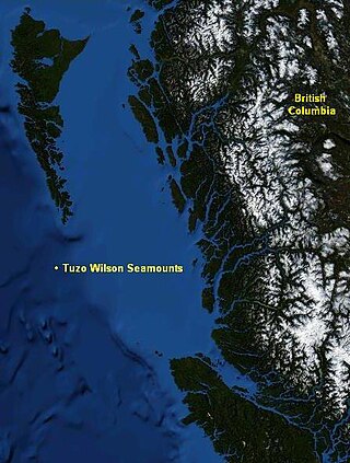
The Tuzo Wilson Seamounts, also called J. Tuzo Wilson Knolls and Tuzo Wilson Knolls, are two young active submarine volcanoes off the coast of British Columbia, Canada, located 200 km (124 mi) northwest of Vancouver Island and south of the Haida Gwaii archipelago The two seamounts are members of the Kodiak-Bowie Seamount chain, rising 500 m (1,640 ft) to 700 m (2,297 ft) above the mean level of the northeastern Pacific Ocean and is a seismically active site southwest of the southern end of the Queen Charlotte Fault. They are named after Canadian geologist John Tuzo Wilson.
The Easter hotspot is a volcanic hotspot located in the southeastern Pacific Ocean. The hotspot created the Sala y Gómez Ridge which includes Easter Island, Salas y Gómez Island and the Pukao Seamount which is at the ridge's young western edge. Easter Island, because of its tectonomagmatic features, represents an end-member type of hotspot volcano in this chain.

Hodgkins Seamount is a seamount in the Kodiak-Bowie Seamount chain, located south of Pierce Seamount and north of Bowie Seamount. It has apparently experienced two generically different episodes of volcanism, separated by about 12 million years. Like the rest of the Kodiak-Bowie seamounts, it was formed by the Bowie hotspot.

Peirce Seamount, also called Pierce Seamount, is a seamount located in the Pacific Ocean west of the Queen Charlotte Islands, British Columbia, Canada. It lies between Denson Seamount and Hodgkins Seamount and is member of the Kodiak-Bowie Seamount chain, a chain of seamounts in southeastern Gulf of Alaska stretching from the Aleutian Trench in the north to Bowie Seamount in the south.

The Louisville Ridge, often now referred to as the Louisville Seamount Chain, is an underwater chain of over 70 seamounts located in the Southwest portion of the Pacific Ocean. As one of the longest seamount chains on Earth it stretches some 4,300 km (2,700 mi) from the Pacific-Antarctic Ridge northwest to the Tonga-Kermadec Trench, where it subducts under the Indo-Australian Plate as part of the Pacific Plate. The chains formation is best explained by movement of the Pacific Plate over the Louisville hotspot although others had suggested by leakage of magma from the shallow mantle up through the Eltanin fracture zone, which it follows closely for some of its course.
The Union Seamount is a seamount located in the Pacific Ocean off the coast of northern Vancouver Island, British Columbia, Canada.
The Fogo Seamounts, also called the Fogo Seamount Chain, are a group of undersea mountains southeast of the Grand Banks of Newfoundland in the North Atlantic Ocean. This seamount chain, lying approximately 500 km (310 mi) offshore from the island of Newfoundland, consists of several submarine volcanoes that have been extinct for millions of years. They are one of the few seamount chains located in Canadian waters off the coast of Atlantic Canada.

The Newfoundland Seamounts are a group of seamounts offshore of Eastern Canada in the northern Atlantic Ocean. Named for the island of Newfoundland, this group of seamounts formed during the Cretaceous period and are poorly studied.
The Samoa hotspot is a volcanic hotspot located in the south Pacific Ocean. The hotspot model describes a hot upwelling plume of magma through the Earth's crust as an explanation of how volcanic islands are formed. The hotspot idea came from J. Tuzo Wilson in 1963 based on the Hawaiian Islands volcanic chain.

The volcanism of Eastern Canada includes the hundreds of volcanic areas and extensive lava formations in Eastern Canada. The region's different volcano and lava types originate from different tectonic settings and types of volcanic eruptions, ranging from passive lava eruptions to violent explosive eruptions. Eastern Canada has very large volumes of magmatic rock called large igneous provinces. They are represented by deep-level plumbing systems consisting of giant dike swarms, sill provinces and layered intrusions. The most capable large igneous provinces in Eastern Canada are Archean age greenstone belts containing a rare volcanic rock called komatiite.
The Macdonald hotspot is a volcanic hotspot in the southern Pacific Ocean. The hotspot was responsible for the formation of the Macdonald Seamount, and possibly the Austral-Cook Islands chain. It probably did not generate all of the volcanism in the Austral and Cook Islands as age data imply that several additional hotspots were needed to generate some volcanoes.
Undersea mountain ranges are mountain ranges that are mostly or entirely underwater, and specifically under the surface of an ocean. If originated from current tectonic forces, they are often referred to as a mid-ocean ridge. In contrast, if formed by past above-water volcanism, they are known as a seamount chain. The largest and best known undersea mountain range is a mid-ocean ridge, the Mid-Atlantic Ridge. It has been observed that, "similar to those on land, the undersea mountain ranges are the loci of frequent volcanic and earthquake activity".

The Tasmantid Seamount Chain is a 2,000 km (1,200 mi) long chain of seamounts in the South Pacific Ocean. The chain consists of over 16 extinct volcanic peaks, many rising more than 4,000 m (13,000 ft) from the seabed. It is one of the two parallel seamount chains alongside the East Coast of Australia; the Lord Howe and Tasmantid seamount chains both run north-south through parts of the Coral Sea and Tasman Sea. These chains have longitudes of approximately 159°E and 156°E respectively.
The Tasmantid hotspot is a volcanic hotspot located in the South Pacific Ocean. The northward movement of the Indo-Australian Plate over the last 60 million years coupled with volcanism of the Tasmantid hotspot has resulted in a north–south line of submarine volcanoes called the Tasmantid Seamount Chain. This includes over 10 seamounts, the youngest of which is the seven million year old Gascoyne Seamount. The Tasmantid hotspot is now 400 km (250 mi) south of Gascoyne Seamount and is defined by a prominent zone of seismic activity.

Musicians Seamounts are a chain of seamounts in the Pacific Ocean, north of the Hawaiian Ridge. There are about 65 seamounts, some of which are named after musicians. These seamounts exist in two chains, one of which has been attributed to a probably now-extinct hotspot called the Euterpe hotspot. Others may have formed in response to plate tectonics associated with the boundary between the Pacific Plate and the former Farallon Plate.
