Protected areas of Tasmania consist of protected areas located within Tasmania and its immediate onshore waters, including Macquarie Island. It includes areas of crown land managed by Tasmanian Government agencies as well as private reserves. As of 2016, 52% of Tasmania's land area has some form of reservation classification, the majority is managed by the Tasmania Parks & Wildlife Service. Marine protected areas cover about 7.9% of state waters.

A seamount is a large geologic landform that rises from the ocean floor that does not reach to the water's surface, and thus is not an island, islet or cliff-rock. Seamounts are typically formed from extinct volcanoes that rise abruptly and are usually found rising from the seafloor to 1,000–4,000 m (3,300–13,100 ft) in height. They are defined by oceanographers as independent features that rise to at least 1,000 m (3,281 ft) above the seafloor, characteristically of conical form. The peaks are often found hundreds to thousands of meters below the surface, and are therefore considered to be within the deep sea. During their evolution over geologic time, the largest seamounts may reach the sea surface where wave action erodes the summit to form a flat surface. After they have subsided and sunk below the sea surface such flat-top seamounts are called "guyots" or "tablemounts".

The benthic zone is the ecological region at the lowest level of a body of water such as an ocean, lake, or stream, including the sediment surface and some sub-surface layers. The name comes from ancient Greek, βένθος (bénthos), meaning "the depths." Organisms living in this zone are called benthos and include microorganisms as well as larger invertebrates, such as crustaceans and polychaetes. Organisms here generally live in close relationship with the substrate and many are permanently attached to the bottom. The benthic boundary layer, which includes the bottom layer of water and the uppermost layer of sediment directly influenced by the overlying water, is an integral part of the benthic zone, as it greatly influences the biological activity that takes place there. Examples of contact soil layers include sand bottoms, rocky outcrops, coral, and bay mud.
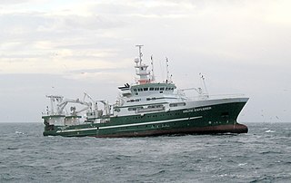
Bottom trawling is trawling along the seafloor. It is also referred to as "dragging". The scientific community divides bottom trawling into benthic trawling and demersal trawling. Benthic trawling is towing a net at the very bottom of the ocean and demersal trawling is towing a net just above the benthic zone. Bottom trawling can be contrasted with midwater trawling, where a net is towed higher in the water column. Midwater trawling catches pelagic fish such as anchovies and mackerel, whereas bottom trawling targets both bottom-living fish (groundfish) and semi-pelagic species such as cod, squid, shrimp, and rockfish.

Demersal fish, also known as groundfish, live and feed on or near the bottom of seas or lakes. They occupy the sea floors and lake beds, which usually consist of mud, sand, gravel or rocks. In coastal waters they are found on or near the continental shelf, and in deep waters they are found on or near the continental slope or along the continental rise. They are not generally found in the deepest waters, such as abyssal depths or on the abyssal plain, but they can be found around seamounts and islands. The word demersal comes from the Latin demergere, which means to sink.

The Lord Howe Rise is a deep sea plateau which extends from south west of New Caledonia to the Challenger Plateau, west of New Zealand in the south west of the Pacific Ocean. To its west is the Tasman Basin and to the east is the New Caledonia Basin. Lord Howe Rise has a total area of about 1,500,000 square km, and generally lies about 750 to 1,200 metres under water. It is part of Zealandia, a much larger continent that is now mostly submerged, and so is composed of continental crust.
The South Tasman Rise is an area of seafloor that lies 550 km south of Hobart, Tasmania in the Southern Ocean where water depths are about 1,500 metres. The South Tasman Rise is also known as the Tasmania Ridge or South Tasmania Ridge. The South Tasman Rise is a sunken landbridge that used to connect Tasmania to Antarctica.

The D'Entrecasteaux Channel is a body of water located between Bruny Island and the south-east of the mainland of Tasmania, Australia. The channel is the mouth for the estuaries of the Derwent and the Huon Rivers and empties into the Tasman Sea of the South Pacific Ocean. It was sighted by Abel Tasman in 1642 and surveyed in 1792 by Bruni d'Entrecasteaux.

The environmental impact of fishing includes issues such as the availability of fish, overfishing, fisheries, and fisheries management; as well as the impact of industrial fishing on other elements of the environment, such as bycatch. These issues are part of marine conservation, and are addressed in fisheries science programs. According to a 2019 FAO report, global production of fish, crustaceans, molluscs and other aquatic animals has continued to grow and reached 172.6 million tonnes in 2017, with an increase of 4.1 percent compared with 2016. There is a growing gap between the supply of fish and demand, due in part to world population growth.
Huon Commonwealth Marine Reserve is a 9,991 km2 marine protected area within Australian waters. The former Tasmanian Seamounts Marine Reserve created in 1999 was incorporated into the Huon reserve in 2007, and is part of the South-east Commonwealth Marine Reserve Network.
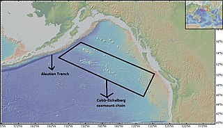
The Cobb-Eickelberg seamount chain is a range of undersea mountains formed by volcanic activity of the Cobb hotspot located in the Pacific Ocean. The seamount chain extends to the southeast on the Pacific Plate, beginning at the Aleutian Trench and terminating at Axial Seamount, located on the Juan de Fuca Ridge. The seamount chain is spread over a vast length of approximately 1800 km. The location of the Cobb hotspot that gives rise to these seamounts is 46° N—130° W. The Pacific plate is moving to the northwest over the hotspot, causing the seamounts in the chain to decrease in age to the southeast. Axial is the youngest seamount and is located approximately 480 km west of Cannon Beach, Oregon. The most studied seamounts that make up this chain are Axial, Brown Bear, Cobb, and Patton seamounts. There are many other seamounts in this chain which have not been explored.

Davidson Seamount is a seamount located off the coast of Central California, 80 mi (129 km) southwest of Monterey and 75 mi (121 km) west of San Simeon. At 26 mi (42 km) long and 8 mi (13 km) wide, it is one of the largest known seamounts in the world. From base to crest, the seamount is 7,480 ft (2,280 m) tall, yet its summit is still 4,101 ft (1,250 m) below the sea surface. The seamount is biologically diverse, with 237 species and 27 types of deep-sea coral having been identified.
Destructive fishing practices are practices that easily result in irreversible damage to aquatic habitats and ecosystems. Many fishing techniques can be destructive if used inappropriately, but some practices are particularly likely to result in irreversible damage. These practices are mostly, though not always, illegal. Where they are illegal, they are often inadequately enforced.

As with other countries, the 200 nautical miles (370 km) exclusive economic zone (EEZ) off the coast of the United States gives its fishing industry special fishing rights. It covers 11.4 million square kilometres, which is the second largest zone in the world, exceeding the land area of the United States.

Hotspot Ecosystem Research and Man's Impact On European Seas (HERMIONE) is an international multidisciplinary project, started in April 2009, that studies deep-sea ecosystems. HERMIONE scientists study the distribution of hotspot ecosystems, how they function and how they interconnect, partially in the context of how these ecosystems are being affected by climate change and impacted by humans through overfishing, resource extraction, seabed installations and pollution. Major aims of the project are to understand how humans are affecting the deep-sea environment and to provide policy makers with accurate scientific information, enabling effective management strategies to protect deep sea ecosystems. The HERMIONE project is funded by the European Commission's Seventh Framework Programme, and is the successor to the HERMES project, which concluded in March 2009.
Tasman Fracture Commonwealth Marine Reserve is a 42,502 km2 marine protected area within Australian waters located off the coast of south-west Tasmania. It extends to the southerly limits of the Australian exclusive economic zone in the Indian Ocean and encompasses the Tasman Fracture. The reserve was established in 2007 and is part of the South-east Commonwealth Marine Reserve Network.
South Tasman Rise Commonwealth Marine Reserve is a 27,704 km2 marine protected area located at the southerly limit of Australia's exclusive economic zone near Tasmania. The reserve was established in 2007 and is part of the South-east Commonwealth Marine Reserve Network.
Freycinet Commonwealth Marine Reserve is a 57,942 km2 marine protected area within Australian waters located off the east coast of Tasmania. It extends to the outer limits of the Australian exclusive economic zone in the Tasman Sea. The reserve was established in 2007 and is part of the South-east Commonwealth Marine Reserve Network. It is the largest reserve of the South-east Network, the area covered is approximately equivalent to about 86% of the land area of Tasmania.
Flinders Commonwealth Marine Reserve is a 27,043km2 marine protected area within Australian waters located off the coast of north-east Tasmania. It extends to the outer limits of the Australian exclusive economic zone in the Tasman Sea. The reserve was established in 2007 and is part of the South-east Commonwealth Marine Reserve Network.
The Norfolk Marine Park is an Australian marine park located in the waters immediately offshore of Norfolk Island, an external territory of Australia. The marine park extends 700 km (430 mi) in a north–south direction and covers an area of 188,444 km2 (72,759 sq mi). The park is assigned IUCN category IV and is one of 8 parks managed under the Temperate East Marine Parks Network.

