Hebrides Terrace Seamount

Last updated
Hebrides Terrace Seamount
Oceans around British Isles satellite image location map.jpg
Red triangle with thick white border.svg
North Atlantic Ocean laea location map.svg
Red triangle with thick white border.svg
Hebrides Terrace Seamount (North Atlantic)
Summit depth1000 metres
Location
Location North Atlantic Ocean
Coordinates 56°28′N10°17′W / 56.467°N 10.283°W / 56.467; -10.283 [1] Coordinates: 56°28′N10°17′W / 56.467°N 10.283°W / 56.467; -10.283 [1]
Geology
Type Guyot

Hebrides Terrace Seamount is a seamount in the Atlantic Ocean, west-southwest from the Hebrides, Scotland. It formed through volcanism during the early Cenozoic in the Rockall Trough 60 million to 67 million years ago and afterwards sank below sea level. Presently, it is a flat-topped underwater mountain that rises to about 980 metres (3,220 ft) depth. "Coral gardens" that host a number of animals are found on its slopes.

Contents

Geography and geomorphology

The seamount lies in the southern Rockall Trough, [2] at the foot of the Scottish continental slope and 166 kilometres (103 mi) west-southwest of Barra Head, Hebrides. [1] It is the smallest of three seamounts in the Rockall Trough; [3] the other two are Anton Dohrn Seamount and Rosemary Bank both north of Hebrides Terrace Seamount, [4] and farther west is the Rockall Bank. [5] It straddles the political border between the United Kingdom and Ireland. [6]

The Hebrides Terrace Seamount is a volcanic [7] guyot, a seamount with a flat top and steep slopes, [1] that rises to a depth of about 980 metres (3,220 ft). [8] It is about 28 by 37 kilometres (17 mi × 23 mi) wide at its basis [3] and its southern and western flanks feature canyons, escarpments and gullies. The surrounding terrain at 2,300 metres (7,500 ft) depth is covered by debris of Plio-Pleistocene age; the debris deposits are almost 1 kilometre (0.62 mi) thick. [2] The Barra and Donegal fans, two sediment fans that form a larger complex, border the Hebrides Terrace Seamount to the north and south, respectively. [9] The seamount has diverted sediment flows, [10] leading to the formation of these two fans [11] and the accumulation of sediments east of Hebrides Terrace Seamount. [12]

Rocks dredged from Hebrides Terrace Seamount have a tholeiitic [13] basaltic composition and define two separate suites, one aluminium-rich and the other aluminium-poor. They contain phenocrysts of augite, olivine, pigeonite, plagioclase and titanomagnetite, which together with ilmenite and pyroxene also occur in the groundmass. [14] The seamount is the location of a positive gravity anomaly that is thought to indicate the presence of a 17 kilometres (11 mi) thick igneous body. [15]

Geologic history

The formation of the Hebrides Terrace Seamount began after the Cretaceous-Palaeogene extinction event. In the early Cenozoic, three pulses of volcanic activity generated the seamount. [2] The volcanism may be correlative to the early Cenozoic Hebridean volcanic province. [16] Ages of 67-60 million years have been obtained on Hebrides Terrace Seamount, [17] as well as 62±1, 51±1 and 48±1 million years ago which coincide with activity at Anton Dohrn Seamount. [18] These dates have been interpreted as indicating fluctuations of the Iceland hotspot. [19]

After the end of volcanic activity, its top was flattened perhaps by Paleocene erosion that has been recognized in the region [7] although other processes may be involved as well. [16] This along with subsidence during the Eocene, Oligocene and in a lesser measure during the Miocene and later time lowered its summit below sea level. [20]

Evidence of more recent seismic activity is found along its southern slopes. [2] On 13 April 1980 a ML3.5 earthquake [21] occurred just west of Hebrides Terrace Seamount; [22] it was probably not an underwater explosion and may have been instead caused by movements along a local fault. [23] Isostatic processes may have caused the earthquake. [24] Another ML3.1 earthquake occurred south of the seamount in 1986. [25]

Life

Xenophyophores (mainly Syringammina fragilissima ), sponges and corals (such as Solenosmilia variabilis ) occur on Hebrides Terrace Seamount, [26] principally on its slopes, [27] and form so-called "coral gardens". [28] These also host black corals, crinoids, egg cases of elasmobranchs, glass sponges and ophiuroids. [26] The faunal communities vary depending on the depth, the substrate (bedrock, cobbles, corals, gravel and sand), the nature of the watermass surrounding them [27] and internal tides which modulate the nutrient supply. [29] The complicated oceanographic regime may facilitate the concentration of nutrients at the seamount, enabling the development of rich biological communities. [2]

Beaked whales, fin whales, harbour porpoises, long-finned pilot whales have been sighted on the seamount. [2] Fish species encountered at Hebrides Terrace Seamount include Atlantic codling, false boarfish and roundnose grenadier. [30] Overfishing has decimated orange roughy spawning aggregations that formerly occurred at Hebrides Terrace Seamount. [2] Sharks and other fish have also declined since the 1970s. [31]

Marine Protected Area

The Hebrides Terrace Seamount, together with a nearby seabed feature known as the Barra Fan, are together designated by the Scottish Government as a Nature Conservation Marine Protected Area named the Barra Fan and Hebrides Terrace Seamount Marine Protected Area. [32]

Related Research Articles

Raised beach Beach or wave-cut platform raised above the shoreline by a relative fall in the sea level

A raised beach, coastal terrace, or perched coastline is a relatively flat, horizontal or gently inclined surface of marine origin, mostly an old abrasion platform which has been lifted out of the sphere of wave activity. Thus, it lies above or under the current sea level, depending on the time of its formation. It is bounded by a steeper ascending slope on the landward side and a steeper descending slope on the seaward side. Due to its generally flat shape it is often used for anthropogenic structures such as settlements and infrastructure.

Rockall Basin Bathymetric feature northwest of Scotland and Ireland

The Rockall Trough is a deep-water bathymetric feature to the northwest of Scotland and Ireland, running roughly from southwest to northeast, flanked on the north by the Rockall Plateau and to the south by the Porcupine Seabight. At the northern end, the channel is bounded by the Wyville-Thomson Ridge, named after Charles Wyville Thomson, professor of zoology at the University of Edinburgh and driving force behind the Challenger Expedition. At the southern end, the trough opens into the Porcupine abyssal plain. The Rockall Basin is a large sedimentary basin that lies beneath the trough. Both are named after Rockall, a rocky islet lying 301.4 km west of St Kilda.

Anton Dohrn Seamount Guyot in the Rockall Trough in the northeast Atlantic

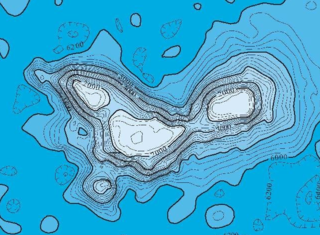
The Anton Dohrn Seamount is a guyot in the Rockall Trough in the northeast Atlantic. It is 1.8 kilometres (1.1 mi) high and is topped with pinnacles, one of which reaches a depth of 530 metres (1,740 ft). Away from the flat top upon which the pinnacles rest, the slopes fall off steeply into the Rockall Trough and a moat in the sediment that surrounds the seamount.

Deep-water coral

The habitat of deep-water corals, also known as cold-water corals, extends to deeper, darker parts of the oceans than tropical corals, ranging from near the surface to the abyss, beyond 2,000 metres (6,600 ft) where water temperatures may be as cold as 4 °C (39 °F). Deep-water corals belong to the Phylum Cnidaria and are most often stony corals, but also include black and horny corals and soft corals including the Gorgonians. Like tropical corals, they provide habitat to other species, but deep-water corals do not require zooxanthellae to survive.

North Atlantic Igneous Province

The North Atlantic Igneous Province (NAIP) is a large igneous province in the North Atlantic, centered on Iceland. In the Paleogene, the province formed the Thulean Plateau, a large basaltic lava plain, which extended over at least 1.3 million km2 (500 thousand sq mi) in area and 6.6 million km3 (1.6 million cu mi) in volume. The plateau was broken up during the opening of the North Atlantic Ocean leaving remnants existing in Northern Ireland, bits of western Scotland, the Faroe Islands, bits of northwestern Iceland, eastern Greenland and western Norway and many of the islands located in the north eastern portion of the North Atlantic Ocean. The igneous province is the origin of the Giant's Causeway and Fingal's Cave. The province is also known as Brito-Arctic province and the portion of the province in the British Isles is also called the British Tertiary Volcanic Province or British Tertiary Igneous Province.

Macdonald hotspot Volcanic hotspot in the southern Pacific Ocean

The Macdonald hotspot is a volcanic hotspot in the southern Pacific Ocean. The hotspot was responsible for the formation of the Macdonald Seamount, and possibly the Austral-Cook Islands chain. It probably did not generate all of the volcanism in the Austral and Cook Islands as age data imply that several additional hotspots were needed to generate some volcanoes.

Hotspot Ecosystem Research and Mans Impact On European Seas International multidisciplinary project that studies deep-sea ecosystems

Hotspot Ecosystem Research and Man's Impact On European Seas (HERMIONE) is an international multidisciplinary project, started in April 2009, that studies deep-sea ecosystems. HERMIONE scientists study the distribution of hotspot ecosystems, how they function and how they interconnect, partially in the context of how these ecosystems are being affected by climate change and impacted by humans through overfishing, resource extraction, seabed installations and pollution. Major aims of the project are to understand how humans are affecting the deep-sea environment and to provide policy makers with accurate scientific information, enabling effective management strategies to protect deep sea ecosystems. The HERMIONE project is funded by the European Commission's Seventh Framework Programme, and is the successor to the HERMES project, which concluded in March 2009.

Gravity anomalies of Britain and Ireland

Variations in the strength of gravity occur from place to place according to the density distribution of the rocks beneath the surface. Such gravity anomalies have been mapped across the British Isles and adjacent areas and they reveal aspects of these islands’ geological structure.

Offshore Indus Basin

The offshore Indus Basin is one of the two basins in offshore Pakistan, the other one being the offshore Makran Basin. The Murray Ridge separates the two basins. The offshore Indus basin is approximately 120 to 140 kilometers wide and has an areal extent of ~20,000 square km.

Limalok Cretaceous-Paleocene guyot in the Marshall Islands

Limalok is a Cretaceous-Paleocene guyot/tablemount in the southeastern Marshall Islands, one of a number of seamounts in the Pacific Ocean. It was probably formed by a volcanic hotspot in present-day French Polynesia. Limalok lies southeast of Mili Atoll and Knox Atoll, which rise above sea level, and is joined to each of them through a volcanic ridge. It is located at a depth of 1,255 metres (4,117 ft) and has a summit platform with an area of 636 square kilometres (246 sq mi).

Alexa Bank is a seamount in Samoa, northwest of Rotuma. The seamount reaches a depth of 18–21 metres (59–69 ft) below sea level and has the appearance of an atoll with a flat top and steep slopes. Some active coral growth takes place at its top, but if it ever was an active atoll it has now drowned. It was probably formed by the Samoa hotspot 24 million years ago, although older volcanism about 40 million years ago has also been identified.

Ioah Guyot

Ioah Guyot is a seamount in the Pacific Ocean, close to the Marshall Islands. Part of the Magellan Seamounts, it is a shield volcano that has erupted alkali basalt and hawaiite 87 million years ago, but may have continued erupting into the Miocene. During the Cretaceous, reefs developed on the guyot.

Ita Mai Tai

Ita Mai Tai is a Cretaceous-early Cenozoic seamount northwest of the Marshall Islands and north of Micronesia. One among a number of seamounts in the Pacific Ocean, it is part of the Magellan Seamounts which may have a hotspot origin although Ita Mai Tai itself may not have formed on a hotspot.

Horizon Guyot Tablemount in the Pacific Ocean

Horizon Guyot is a presumably Cretaceous guyot (tablemount) in the Mid-Pacific Mountains, Pacific Ocean. It is an elongated ridge, over 300 kilometres (190 mi) long and 4.3 kilometres (2.7 mi) high, that stretches in a northeast-southwest direction and has two flat tops; it rises to a minimum depth of 1,443 metres (4,730 ft). The Mid-Pacific Mountains lie west of Hawaii and northeast of the Line Islands.

Lomilik Seamount

Lomilik is a seamount in the Western Pacific Ocean, within the exclusive economic zone of the Marshall Islands. It lies to the west of Anewetak atoll and is named after the best fishing site of Anewetak atoll.

Echo Bank

Echo Bank is an underwater mountain, part of Canary Islands Seamount Province and located southwest of the Canary Islands. Of uncertain geologic origin, it is part of a larger cluster of submarine mountains and rises to a depth of 255 metres (837 ft) below sea level. It has a flat top, indicating that it formerly might have emerged from the sea.

Tropic Seamount

Tropic Seamount is a Cretaceous seamount, part of the Canary Islands Seamount Province. It is located southwest of the Canary Islands, north of Cape Verde and west of Morocco. It is one of a number of seamounts in this part of the Atlantic Ocean, probably formed by volcanic processes triggered by the proximity to the African continent. Tropic Seamount is located at a depth of 970 metres (3,180 ft) and has a summit platform with an area of 120 square kilometres (46 sq mi).

Barra Fan and Hebrides Terrace Seamount Marine Protected Area Seabed features in the North Atlantic

The Barra Fan and Hebrides Terrace Seamount is the name given to a Nature Conservation Marine Protected Area that lies in Scottish waters to the west of the Outer Hebrides, adjacent to the boundary with Ireland. It covers two distinct geological features of the North Atlantic Ocean: the Barra Fan and the Hebrides Terrace Seamount.

Capricorn Seamount is a seamount in Tonga. It rises 4 kilometres (2.5 mi) to a depth of about 360 m (1,180 ft) and is capped off by a 15 km (9.3 mi) wide summit platform. It appears to be a submerged volcano of Miocene age that may be part of a volcanic chain with Niue. Capricorn Seamount is located on the eastern flank of the Tonga Trench and is in the process of breaking up; in turn the trench has been altered by the interaction with the downgoing seamount.

Coral Patch Seamount Seamount between Madeira and Portugal

Coral Patch Seamount is a seamount between Madeira and mainland Portugal in the North Atlantic Ocean. It is an elongated 120 kilometres (75 mi) long and 70 kilometres (43 mi) wide mountain that rises to a depth of about 645 metres (2,116 ft), with nine volcanic cones on its summit. It has steeper southern slopes and a gentle northern slope. To its west lies Ampére Seamount, and together with several neighbouring seamounts it is one of the Horseshoe Seamounts.

References

  1. 1 2 3 4 Buckley & Bailey 1975, p. 37.
  2. 1 2 3 4 5 6 7 Henry et al. 2014, p. 2.
  3. 1 2 El-Tokhi, Omran & El-Muslem 2005, p. 9.
  4. El-Tokhi, Omran & El-Muslem 2005, p. 10.
  5. Stashchuk & Vlasenko 2005, p. 606.
  6. Dorschel, Boris; Wheeler, Andrew J.; Monteys, Xavier; Verbruggen, Koen (2010). Atlas of the Deep-Water Seabed. Dordrecht: Springer Netherlands. p. 66. doi:10.1007/978-90-481-9376-9. ISBN   978-90-481-9375-2.
  7. 1 2 Buckley & Bailey 1975, p. 44.
  8. Small, J.; Sawyer, T. C.; Scott, J. C. (1 March 1999). "The evolution of an internal bore at the Malin shelf break". Annales Geophysicae. 17 (4): 548. Bibcode:1999AnGeo..17..547S. doi: 10.1007/s00585-999-0547-x . ISSN   1432-0576.
  9. Armishaw, Holmes & Stow 1998, p. 81.
  10. Armishaw, Holmes & Stow 1998, p. 87.
  11. Armishaw, Holmes & Stow 1998, p. 89.
  12. Sacchetti, F.; Benetti, S.; Georgiopoulou, A.; Shannon, P. M.; O'Reilly, B. M.; Dunlop, P.; Quinn, R.; Ó Cofaigh, C. (1 January 2012). "Deep-water geomorphology of the glaciated Irish margin from high-resolution marine geophysical data". Marine Geology. 291–294: 114. Bibcode:2012MGeol.291..113S. doi:10.1016/j.margeo.2011.11.011. ISSN   0025-3227.
  13. El-Tokhi, Omran & El-Muslem 2005, p. 13.
  14. El-Tokhi, Omran & El-Muslem 2005, p. 12.
  15. C King (2016). A revised correlation of Tertiary rocks in the British Isles and adjacent areas of NW Europe. The Geological Society. p. 575. ISBN   9781862397286.
  16. 1 2 Buckley & Bailey 1975, p. 40.
  17. El-Tokhi, Omran & El-Muslem 2005, p. 15.
  18. O'Connor et al. 2000, p. 955.
  19. O'Connor et al. 2000, p. 957.
  20. El-Tokhi, Omran & El-Muslem 2005, p. 17.
  21. Jacob, Neilson & Ward 1983, p. 289.
  22. Jacob, Neilson & Ward 1983, p. 288.
  23. Jacob, Neilson & Ward 1983, p. 295.
  24. Baltzer, A.; Holmes, R.; Evans, D. (1 January 1998). "Debris flows on the Sula Sgeir Fan, NW of Scotland". Geological Society, London, Special Publications. 129 (1): 110. Bibcode:1998GSLSP.129..105B. doi:10.1144/GSL.SP.1998.129.01.07. ISSN   0305-8719. S2CID   131561624.
  25. Long, David; Holmes, Richard (August 2001). Submarine landslides and tsunami threat to Scotland. International Tsunami Symposium. Proceedings of the International Tsunami Symposium. Seattle. p. 358 via ResearchGate.
  26. 1 2 Henry et al. 2014, p. 3.
  27. 1 2 Henry et al. 2014, p. 4.
  28. Findlay, Helen S.; Hennige, Sebastian J.; Wicks, Laura C.; Navas, Juan Moreno; Woodward, E. Malcolm S.; Roberts, J. Murray (20 January 2014). "Fine-scale nutrient and carbonate system dynamics around cold-water coral reefs in the northeast Atlantic". Scientific Reports. 4 (1): 2. Bibcode:2014NatSR...4E3671F. doi: 10.1038/srep03671 . ISSN   2045-2322. PMC   3895924 . PMID   24441283.
  29. Henry et al. 2014, p. 5.
  30. "Seamounts in the OSPAR maritime area". Havforskningsinstituttet (in Norwegian Bokmål).
  31. Henry et al. 2014, p. 6.
  32. "SiteLink: The Barra Fan and Hebrides Terrace Seamount MPA(NC)". Scottish Natural Heritage. Retrieved 20 February 2020.

Sources