Related Research Articles

Tides are the rise and fall of sea levels caused by the combined effects of the gravitational forces exerted by the Moon and are also caused by the Earth and Moon orbiting one another.

A fathom is a unit of length in the imperial and the U.S. customary systems equal to 6 feet (1.8288 m), used especially for measuring the depth of water. The fathom is neither an international standard (SI) unit, nor an internationally accepted non-SI unit. Historically it was the maritime measure of depth in the English-speaking world but, apart from within the US, charts now use metres.

Hydrography is the branch of applied sciences which deals with the measurement and description of the physical features of oceans, seas, coastal areas, lakes and rivers, as well as with the prediction of their change over time, for the primary purpose of safety of navigation and in support of all other marine activities, including economic development, security and defense, scientific research, and environmental protection.

A nautical chart or hydrographic chart is a graphic representation of a sea region or water body and adjacent coasts or banks. Depending on the scale of the chart, it may show depths of water (bathymetry) and heights of land (topography), natural features of the seabed, details of the coastline, navigational hazards, locations of natural and human-made aids to navigation, information on tides and currents, local details of the Earth's magnetic field, and human-made structures such as harbours, buildings, and bridges. Nautical charts are essential tools for marine navigation; many countries require vessels, especially commercial ships, to carry them. Nautical charting may take the form of charts printed on paper or computerized electronic navigational charts. Recent technologies have made available paper charts which are printed "on demand" with cartographic data that has been downloaded to the commercial printing company as recently as the night before printing. With each daily download, critical data such as Local Notices to Mariners are added to the on-demand chart files so that these charts are up to date at the time of printing.
A hydrographic office is an organization which is devoted to acquiring and publishing hydrographic information.

Slack tide or slack water is the short period in a body of tidal water when the water is completely unstressed, and there is no movement either way in the tidal stream. It occurs before the direction of the tidal stream reverses. Slack water can be estimated using a tidal atlas or the tidal diamond information on a nautical chart. The time of slack water, particularly in constricted waters, does not occur at high and low water, and in certain areas, such as Primera Angostura, the ebb may run for up to three hours after the water level has started to rise. Similarly, the flood may run for up to three hours after the water has started to fall. In 1884, Thornton Lecky illustrated the phenomenon with an inland basin of infinite size, connected to the sea by a narrow mouth. Since the level of the basin is always at mean sea level, the flood in the mouth starts at half tide, and its velocity is at its greatest at the time of high water, with the strongest ebb occurring conversely at low water.
The United Kingdom Hydrographic Office (UKHO) is the UK's agency for providing hydrographic and marine geospatial data to mariners and maritime organisations across the world. The UKHO is a trading fund of the Ministry of Defence (MoD) and is located in Taunton, Somerset, with a workforce of approximately 900 staff.

Admiralty charts are nautical charts issued by the United Kingdom Hydrographic Office (UKHO) and subject to Crown Copyright. Over 3,500 Standard Nautical Charts (SNCs) and 14,000 Electronic Navigational Charts (ENCs) are available with the Admiralty portfolio offering the widest official coverage of international shipping routes and ports, in varying detail.
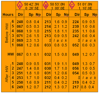
Tidal diamonds are symbols on British admiralty charts and others that indicate the direction and speed of tidal streams.
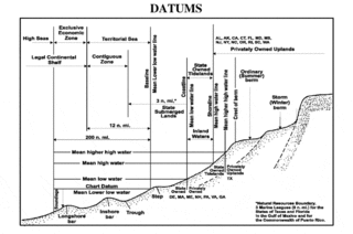
A chart datum is the water level surface serving as origin of depths displayed on a nautical chart and for reporting and predicting tide heights. A chart datum is generally derived from some tidal phase, in which case it is also known as a tidal datum. Common chart datums are lowest astronomical tide (LAT) and mean lower low water (MLLW). In non-tidal areas, e.g. the Baltic Sea, mean sea level (MSL) is used. A chart datum is a type of vertical datum and must not be confused with the horizontal datum for the chart.
A tidal river is a river whose flow and level are caused by tides. A section of a larger river affected by the tides is a tidal reach, but it may sometimes be considered a tidal river if it had been given a separate and another title name.

San Carlos Water is a bay/fjord on the west coast of East Falkland, facing onto the Falkland Sound.

A withy or withe is a strong flexible willow stem, typically used in thatching, basketmaking, gardening and for constructing woven wattle hurdles. The term is also used to refer to any type of flexible rod of natural wood used in rural crafts such as hazel or ash created through coppicing or pollarding.

Dartmouth Harbour is a natural port located in Dartmouth, Devon, England. It is situated at the mouth of the River Dart on the English Channel. Bayard's Cove Fort is a small fort, which was built to defend the harbour's entrance. The crafts which dock at the port are mainly local fishing vessels, naval ships and luxury yachts; warships routinely visit the harbour. The River Dart is navigable from Dartmouth to the old weir location at Totnes.
The Day Skipper qualification confirms that the successful candidate has the knowledge needed to skipper a yacht on shorter, coastal cruises during daylight. The Royal Yachting Association administers the qualification, although most of the training is carried out by private companies.
A Standard port is a port whose tidal predictions are directly given in the Tide tables.
Vertical Offshore Reference Frames (VORF) is a set of high resolution surface models, published and maintained by the UK Hydrographic Office, which together define a vertical datum for hydrographic surveying and charting in the United Kingdom and Ireland.
The Edinburgh Channels, formerly a single channel known as the Bullock Channel and then the Duke of Edinburgh Channel are two roughly parallel transverse channels in the Thames Estuary. They used to be important for navigation, providing a deep approach to the River Thames from the south-east through the sandbanks of the estuary. The opening of an alternative channel in 2000 has greatly reduced their use, but having been surveyed and studied extensively over the past two centuries they provide an important example of the processes that shape shallow water landforms.

The French Pass Lighthouse together with a stone beacon mark a channel through the turbulent waters between Rangitoto ki te Tonga / D’Urville Island and the South Island. The New Zealand List of Lights calls the lighthouse Channel Point.
References
- ↑ United Kingdom Hydrographic Office 2015, p. 1.
- ↑ Noice 2015, p. 60.
- ↑ United Kingdom Hydrographic Office 2015, pp. 18–19.
- ↑ United Kingdom Hydrographic Office 2015, pp. 20–23.
- ↑ Cunliffe 2017, pp. 145–147.