A seamount is a mountain rising from the ocean seafloor that does not reach to the water's surface, and thus is not an island, islet or cliff-rock. Seamounts are typically formed from extinct volcanoes that rise abruptly and are usually found rising from the seafloor to 1,000–4,000 m (3,300–13,100 ft) in height. They are defined by oceanographers as independent features that rise to at least 1,000 m (3,281 ft) above the seafloor, characteristically of conical form. The peaks are often found hundreds to thousands of meters below the surface, and are therefore considered to be within the deep sea. During their evolution over geologic time, the largest seamounts may reach the sea surface where wave action erodes the summit to form a flat surface. After they have subsided and sunk below the sea surface such flat-top seamounts are called "guyots" or "tablemounts"

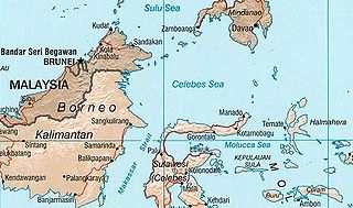
The Celebes Sea of the western Pacific Ocean is bordered on the north by the Sulu Archipelago and Sulu Sea and Mindanao Island of the Philippines, on the east by the Sangihe Islands chain, on the south by Sulawesi's Minahassa Peninsula, and on the west by Kalimantan in Indonesia. It extends 420 miles (675 km) north-south by 520 mi (840 km) east-west and has a total surface area of 110,000 square miles (280,000 km2), to a maximum depth of 20,300 feet (6,200 m). The sea opens southwest through the Makassar Strait into the Java Sea.

Lōihi Seamount is an active submarine volcano about 35 km (22 mi) off the southeast coast of the island of Hawaii. The top of the seamount is about 975 m (3,000 ft) below sea level. This seamount is on the flank of Mauna Loa, the largest shield volcano on Earth. Lōihi, meaning "long" in Hawaiian, is the newest volcano in the Hawaiian-Emperor seamount chain, a string of volcanoes that stretches over 5,800 km (3,600 mi) northwest of Lōʻihi. Unlike most active volcanoes in the Pacific Ocean that make up the active plate margins on the Pacific Ring of Fire, Lōʻihi and the other volcanoes of the Hawaiian-Emperor seamount chain are hotspot volcanoes and formed well away from the nearest plate boundary. Volcanoes in the Hawaiian Islands arise from the Hawaii hotspot, and as the youngest volcano in the chain, Lōihi is the only Hawaiian volcano in the deep submarine preshield stage of development.

The Monteregian Hills is a linear chain of isolated hills in Montreal and Montérégie, between the Laurentians and the Appalachians.
In the United States the Office of Ocean Exploration (OE) is a division of the National Oceanic and Atmospheric Administration (NOAA) run under the auspices of the Office of Oceanic and Atmospheric Research (OAR).

The Bowie hotspot is a volcanic hotspot, located 180 kilometres (110 mi) west of the Queen Charlotte Islands in the Pacific Ocean.

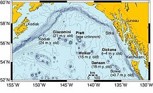
The Kodiak–Bowie Seamount chain, also called the Pratt–Welker Seamount chain and the Kodiak Seamounts, is a seamount chain in southeastern Gulf of Alaska stretching from the Aleutian Trench in the north to Bowie Seamount, the youngest volcano in the chain, which lies 180 km (112 mi) west of the Queen Charlotte Islands, British Columbia, Canada. The oldest volcano in the chain is the Kodiak Seamount. Although the Kodiak Seamount is the oldest extant seamount in the Kodiak-Bowie chain, the adjacent lower slope contains transverse scars indicating earlier subduction of seamounts.

Kodiak Seamount is the oldest seamount in the Kodiak-Bowie Seamount chain, with an estimated age of 24 million years. It lies at the northernmost end of the chain and its flat-topped summit is strewn with fault lines. Like the rest of the Kodiak-Bowie seamounts, it was formed by the Bowie hotspot.

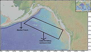
The Cobb-Eickelberg seamount chain is a range of undersea mountains formed by volcanic activity of the Cobb hotspot located in the Pacific Ocean. The seamount chain extends to the southeast on the Pacific Plate, beginning at the Aleutian Trench and terminating at Axial Seamount, located on the Juan de Fuca Ridge.The seamount chain is spread over a vast length of approximately 1200 km. The location of the Cobb hotspot that gives rise to these seamounts is 46° N -130° W. The Pacific plate is moving to the northwest over the hotspot, causing the seamounts in the chain to decrease in age to the southeast. Axial is the youngest seamount and is located approximately 480 km west of Cannon Beach, Oregon. The most studied seamounts that make up this chain are Axial, Brown Bear, Cobb, and Patton seamounts. There are many other seamounts in this chain which have not been explored.
Cobb Seamount is a seamount and guyot located 500 km (310 mi) west of Grays Harbor, Washington, United States. Cobb Seamount is one of the seamounts in the Cobb–Eickelberg Seamount chain, a chain of underwater volcanoes created by the Cobb hotspot that terminates near the coast of Alaska. It lies just west of the Cascadia subduction zone, and was discovered in August 1950 by the U.S. Fish and Wildlife Service fisheries research vessel R/V John N. Cobb. By 1967, over 927 km (576 mi) of soundings and dozens of samples from the seamount had been collected.

The Hawaii hotspot is a volcanic hotspot located near the namesake Hawaiian Islands, in the northern Pacific Ocean. One of the most well-known and heavily studied hotspots in the world, the Hawaii plume is responsible for the creation of the Hawaiian – Emperor seamount chain, a chain of volcanoes over 5,800 kilometres (3,600 mi) long. Four of these volcanoes are active, two are dormant, and more than 123 are extinct, many having since been ground beneath the waves by erosion as seamounts and atolls. The chain extends from south of the island of Hawaiʻi to the edge of the Aleutian Trench, near the eastern edge of Russia.

Davidson Seamount is a seamount located off the coast of Central California, 80 mi (129 km) southwest of Monterey and 75 mi (121 km) west of San Simeon. At 26 mi (42 km) long and 8 mi (13 km) wide, it is one of the largest known seamounts in the world. From base to crest, the seamount is 7,480 ft (2,280 m) tall, yet its summit is still 4,101 ft (1,250 m) below the sea surface. The seamount is biologically diverse, with 237 species and 27 types of deep-sea coral having been identified.
The Gorringe Ridge is a seamount in the Atlantic Ocean. It is located about 130 miles (210 km) west of Portugal, between the Azores and the Strait of Gibraltar along the Azores–Gibraltar fault zone. It is about 60 km wide and 180 km long in the northeast direction.
Crossota millsae is a species of deep-sea hydrozoan. Males and females have both been described, and it reproduces sexually. They are viviparous and females brood baby medusae attached to the gastric canals inside the sub-umbrellar space.

The Mariana Plate is a micro tectonic plate located west of the Mariana Trench which forms the basement of the Mariana Islands which form part of the Izu-Bonin-Mariana Arc. It is separated from the Philippine Sea Plate to the west by a divergent boundary with numerous transform fault offsets. The boundary between the Mariana and the Pacific Plate to the east is a subduction zone with the Pacific Plate subducting beneath the Mariana. This eastern subduction is divided into the Mariana Trench, which forms the southeastern boundary, and the Izu-Ogasawara Trench the northeastern boundary. The subduction plate motion is responsible for the shape of the Mariana plate and back arc.

Koko Guyot is a 48.1-million-year-old guyot, a type of underwater volcano with a flat top, which lies near the southern end of the Emperor seamounts, about 200 km (124 mi) north of the "bend" in the volcanic Hawaiian-Emperor seamount chain. Pillow lava has been sampled on the north west flank of Koko Seamount, and the oldest dated lava is 40 million years old. Seismic studies indicate that it is built on a 9 km (6 mi) thick portion of the Pacific Plate. The oldest rock from the north side of Koko Seamount is dated at 52.6 and the south side of Koko at 50.4 million years ago. To the southeast of the bend is Kimmei Seamount at 47.9 million years ago and southeast of it, Daikakuji at 46.7.

Nintoku Seamount or Nintoku Guyot is a seamount and guyot in the Hawaiian-Emperor seamount chain. It is a large, irregularly shaped volcano that last erupted 66 million years ago. Three lava flows have been sampled at Nintoku Seamount; the flows are almost all alkalic (subaerial) lava. It is 56.2 million years old.

NOAAS Okeanos Explorer is a converted United States Navy ship, now an exploratory vessel for the National Oceanic and Atmospheric Administration (NOAA), officially launched in 2010. Starting in 2010, NOAA entered into a five-year partnership with the San Francisco Exploratorium. The focus is on gathering scientific information about oceans for the public as well as for scientific uses. As much as 95% of the ocean remains unexplored, NOAA officials said. The ship is equipped with cameras and will provide real-time viewing of the ocean floor for scientists and for the public.

Rodriguez Seamount is a seamount and guyot located about 150 km (93 mi) off the coast of Central California. It is structurally similar to the nearby Guide, Pioneer, Gumdrop, and Davidson seamounts, all located roughly between 37.5° and 34.0° degrees of latitude. This group of seamounts is morphologically unique, and the mounts are very similar to one another. The seamount structures run parallel to an ancient spreading center which has since been replaced in its role by the San Andreas Fault system.

Patton Seamount is a prominent seamount in the Cobb–Eickelberg Seamount chain in the Gulf of Alaska. Located 166 nmi east of Kodiak Island and reaching to within 160 m (520 ft) of the ocean surface, Patton is one of the largest seamounts in the Cobb–Eickelberg Seamount chain. It was originally created near the coast of Oregon by the Cobb hotspot 33 million years ago, and was moved to its present location by tectonic plate movement. Patton is one of the most well-understood seamounts, as a major expedition using DSV Alvin in 1999 and another in 2002 helped define the scope of the seamount's biological community. Like other large seamounts, Patton acts as an ecological hub for sea life. Dives have revealed that the volcano is heavily encrusted in sea life of various forms, including sea stars, corals, king crabs, demersal rockfish, and other species.


