Related Research Articles

The geography of Antarctica is dominated by its south polar location and, thus, by ice. The Antarctic continent, located in the Earth's southern hemisphere, is centered asymmetrically around the South Pole and largely south of the Antarctic Circle. It is washed by the Southern Ocean or, depending on definition, the southern Pacific, Atlantic, and Indian Oceans. It has an area of more than 14 million km2.

Physical geography is one of the two fields of geography. Physical geography is the branch of natural science which deals with the processes and patterns in the natural environment such as the atmosphere, hydrosphere, biosphere, and geosphere, as opposed to the cultural or built environment, the domain of human geography.
A drumlin, from the Irish word droimnín, first recorded in 1833, in the classical sense is an elongated hill in the shape of an inverted spoon or half-buried egg formed by glacial ice acting on underlying unconsolidated till or ground moraine. Assemblages of drumlins are referred to as fields or swarms; they can create a landscape which is often described as having a 'basket of eggs topography'.

Geomorphology is the scientific study of the origin and evolution of topographic and bathymetric features created by physical, chemical or biological processes operating at or near the Earth's surface. Geomorphologists seek to understand why landscapes look the way they do, to understand landform and terrain history and dynamics and to predict changes through a combination of field observations, physical experiments and numerical modeling. Geomorphologists work within disciplines such as physical geography, geology, geodesy, engineering geology, archaeology, climatology and geotechnical engineering. This broad base of interests contributes to many research styles and interests within the field.

In glaciology, an ice sheet, also known as a continental glacier, is a mass of glacial ice that covers surrounding terrain and is greater than 50,000 km2 (19,000 sq mi). The only current ice sheets are in Antarctica and Greenland; during the Last Glacial Period at Last Glacial Maximum (LGM) the Laurentide Ice Sheet covered much of North America, the Weichselian ice sheet covered northern Europe and the Patagonian Ice Sheet covered southern South America.
The Byrd Polar and Climate Research Center (BPCRC) is a polar, alpine, and climate research center at Ohio State University founded in 1960.

The Hudson Mountains are a mountain range in western Ellsworth Land just east of Cranton Bay and Pine Island Bay at the eastern extremity of Amundsen Sea. They are of volcanic origin, consisting of low scattered mountains and nunataks that protrude through the West Antarctic Ice Sheet. The Hudson Mountains are bounded on the north by Cosgrove Ice Shelf and on the south by Pine Island Glacier.

An ice stream is a region of fast-moving ice within an ice sheet. It is a type of glacier, a body of ice that moves under its own weight. They can move upwards of 1,000 metres (3,300 ft) a year, and can be up to 50 kilometres (31 mi) in width, and hundreds of kilometers in length. They tend to be about 2 km (1.2 mi) deep at the thickest, and constitute the majority of the ice that leaves the sheet. In Antarctica, the ice streams account for approximately 90% of the sheet's mass loss per year, and approximately 50% of the mass loss in Greenland.

The Quaternary glaciation, also known as the Pleistocene glaciation, is an alternating series of glacial and interglacial periods during the Quaternary period that began 2.58 Ma and is ongoing. Although geologists describe the entire time period up to the present as an "ice age", in popular culture the term "ice age" is usually associated with just the most recent glacial period during the Pleistocene or the Pleistocene epoch in general. Since planet Earth still has ice sheets, geologists consider the Quaternary glaciation to be ongoing, with the Earth now experiencing an interglacial period.

The late Paleozoic icehouse, also known as the late Paleozoic ice age and formerly known as the Karoo ice age, occurred from 360 to 260 million years ago (Mya), and large land-based ice-sheets were then present on Earth's surface. It was the second major glacial period of the Phanerozoic. It is named after the tillite found in the Karoo Basin of South Africa, where evidence for the ice age was first clearly identified in the 19th century.
The Holocene glacial retreat is a geographical phenomenon that involved the global deglaciation of glaciers that previously had advanced during the Last Glacial Maximum. Ice sheet retreat initiated ca. 19,000 years ago and accelerated after ca. 15,000 years ago. The Holocene, starting with abrupt warming 11,700 years ago, resulted in rapid melting of the remaining ice sheets of North America and Europe.
Superficial deposits refer to geological deposits typically of Quaternary age. These geologically recent unconsolidated sediments may include stream channel and floodplain deposits, beach sands, talus gravels and glacial drift and moraine. All pre-Quaternary deposits are referred to as bedrock.
The geology of Cheshire in England consists mainly of Triassic sandstones and mudstones. To the north west of Cheshire, these rocks are heavily faulted and the underlying Carboniferous Coal Measures are thrown up. Around the areas of Poynton and Macclesfield, the coal is close to the surface and was easily mined. Below the Coal Measures is the Millstone Grit, which appears towards the Derbyshire border on the flanks of the Peak District dome.
Fluvioglacial landforms are those that result from the associated erosion and deposition of sediments caused by glacial meltwater. These landforms may also be referred to as glaciofluvial in nature. Glaciers contain suspended sediment loads, much of which is initially picked up from the underlying landmass. Landforms are shaped by glacial erosion through processes such as glacial quarrying, abrasion, and meltwater. Glacial meltwater contributes to the erosion of bedrock through both mechanical and chemical processes.
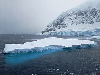
Andvord Bay is a bay-like fjord, 9 nautical miles (17 km) long and 3 nautical miles (6 km) wide, which lies between Beneden Head and Duthiers Point along the west coast of Graham Land.
Deglaciation is the transition from full glacial conditions during ice ages, to warm interglacials, characterized by global warming and sea level rise due to change in continental ice volume. Thus, it refers to the retreat of a glacier, an ice sheet or frozen surface layer, and the resulting exposure of the Earth's surface. The decline of the cryosphere due to ablation can occur on any scale from global to localized to a particular glacier. After the Last Glacial Maximum, the last deglaciation begun, which lasted until the early Holocene. Around much of Earth, deglaciation during the last 100 years has been accelerating as a result of climate change, partly brought on by anthropogenic changes to greenhouse gases.

Grafton Notch State Park is a public recreation area in Grafton Township, Oxford County, Maine. The state park occupies 3,129 acres (1,266 ha) surrounding Grafton Notch, the mountain pass between Old Speck Mountain and Baldpate Mountain. The park is abutted by the eastern and western sections of the Mahoosuc Public Reserved Land, which total 31,807 acres (12,872 ha). The park is managed by the Department of Agriculture, Conservation and Forestry.
Meltwater pulse 1B (MWP1b) is the name used by Quaternary geologists, paleoclimatologists, and oceanographers for a period of either rapid or just accelerated post-glacial sea level rise that some hypothesize to have occurred between 11,500 and 11,200 years ago at the beginning of the Holocene and after the end of the Younger Dryas. Meltwater pulse 1B is also known as catastrophic rise event 2 (CRE2) in the Caribbean Sea.

The early Holocene sea level rise (EHSLR) was a significant jump in sea level by about 60 m (197 ft) during the early Holocene, between about 12,000 and 7,000 years ago, spanning the Eurasian Mesolithic. The rapid rise in sea level and associated climate change, notably the 8.2 ka cooling event , and the loss of coastal land favoured by early farmers, may have contributed to the spread of the Neolithic Revolution to Europe in its Neolithic period.