The Deep Sea Drilling Project (DSDP) was an ocean drilling project operated from 1968 to 1983. The program was a success, as evidenced by the data and publications that have resulted from it. The data are now hosted by Texas A&M University, although the program was coordinated by the Scripps Institution of Oceanography at the University of California, San Diego. DSDP provided crucial data to support the seafloor spreading hypothesis and helped to prove the theory of plate tectonics. DSDP was the first of three international scientific ocean drilling programs that have operated over more than 40 years. It was followed by the Ocean Drilling Program (ODP) in 1985, the Integrated Ocean Drilling Program in 2004 and the present International Ocean Discovery Program in 2013. [1]
The initial contract between the National Science Foundation (NSF) and the Regents of the University of California was signed on June 24, 1966. This contract initiated the first phase of the DSDP, which was based in Scripps Institution of Oceanography at the University of California, San Diego. Global Marine, Inc. conducted the drilling operations. The Levingston Shipbuilding Company laid the keel of the Glomar Challenger on October 18, 1967, in Orange, Texas. [2] It sailed down the Sabine River to the Gulf of Mexico, and after a period of testing, DSDP accepted the ship on August 11, 1968. [1]
Through contracts with Joint Oceanographic Institutions (JOI), NSF supported the scientific advisory structure for the project and funded pre-drilling geophysical site surveys. Scientific planning was conducted under the auspices of the Joint Oceanographic Institutions for Deep Earth Sampling (JOIDES). The JOIDES advisory group consisted of 250 distinguished scientists from academic institutions, government agencies, and private industry from all over the world. Over the next 30 months, the second phase consisted of drilling and coring in the Atlantic, Pacific, and Indian Ocean as well as the Mediterranean and Red Sea. Technical and scientific reports followed during the period. The second phase of DSDP ended on August 11, 1972. [3]
The success of the Glomar Challenger was almost immediate. On one of the sites with a water depth of 1,067 m (3,501 feet), core samples revealed the existence of salt domes. Oil companies received samples after an agreement to publish their analysis. The potential of oil beneath deep ocean salt domes remains an important avenue for commercial development today. [4] [1]
As for the purpose of the scientific exploration, one of the most important discoveries was made when the crew drilled 17 holes at 10 different locations along an oceanic ridge between South America and Africa. The retrieved core samples provided strong proof for continental drift and seafloor renewal at rift zones. [5] This confirmation of Alfred Wegener's theory of continental drift strengthened the proposal of a single, ancient land mass, which is called Pangaea. The samples gave further evidence to support the plate tectonics theory, which at the time attempted to explain the formation of mountain ranges, earthquakes, and oceanic trenches. [6] Another discovery was how youthful the ocean floor is in comparison to Earth's geologic history. After analysis of samples, scientists concluded that the ocean floor is probably no older than 200 million years. [7] [1] This is in comparison with the 4.5 billion-year age of the Earth.
The International Phase of Ocean Drilling (IPOD) began in 1975 with the Federal Republic of Germany, Japan, the United Kingdom, the Soviet Union, and France joining the United States in field work aboard the Glomar Challenger and in post-cruise scientific research. [8] The Glomar Challenger docked for the last time with DSDP in November 1983. Parts of the ship, such as its dynamic positioning system, engine telegraph, and thruster console, are stored at the Smithsonian Institution in Washington, D.C. With the advent of larger and more advanced drilling ships, the JOIDES Resolution replaced the Glomar Challenger in January 1985. The new program, called the Ocean Drilling Program (ODP), continued exploration from 1985 to 2003, at which point it was replaced by the Integrated Ocean Drilling Program (IODP). [1]
Although itself a remarkable engineering accomplishment, the Glomar Challenger saw many advances in deep-ocean drilling. One problem solved involved the replacement of worn drill bits. [2] A length of pipe suspended from the ship down to the bottom of the sea might have been as long as 6,243 m (20,483 feet). The maximum depth penetrated through the ocean bottom could have been as great as 1,299 m (4,262 feet). To replace the bit, the drill string must be raised, a new bit attached, and the string remade down to the bottom. However, the crew had to thread this string back into the same drill hole. The technique for this formidable task was accomplished on June 14, 1970, in the Atlantic Ocean in 3,000 m (10,000 feet) of water off the coast of New York. This re-entry was accomplished with the use of sonar scanning equipment and a re-entry cone that had a diameter of 5 m (16 feet) and height of 4.5 m (14 feet). [2]
One major technological advance was the extended use of the holes after drilling. [9] Geophysical and geochemical measurements were made during and after drilling, and occasionally long-term seismic monitoring devices were installed in the holes. This extended understanding of the dynamic processes involved in plate tectonics. Another technological advance involved the introduction of the hydraulic piston corer (HPC [10] ) in 1979, which permitted the recovery of virtually undisturbed cores of sediment. [11] This greatly enhanced the ability of scientists to study ancient ocean environments.
From August 11, 1968, to November 11, 1983, the Glomar Challenger achieved the following accomplishments:
Total distance penetrated below the seafloor | 325,548 m (1,068,071 feet) |
Total interval cored | 170,043 m (557,884 feet) |
Total core recovered and stored | 97,056 m (318,425 feet) |
Overall core recovery | 57% |
Number of cores recovered | 19,119 |
Number of sites investigated | 624 |
Number of expeditions completed | 96 |
Deepest penetration beneath the ocean floor | 1,741 m (5,712 feet) |
Maximum penetration into basaltic crust | 1,080 m (3,540 feet) |
Deepest water | 7,044 m (23,110 feet) |
Total distance traveled | 375,632 nautical miles (695,670 km) |
The ship retrieved core samples in 9-meter-long (30 ft) cores with a diameter of 6.5 cm (2.5 inches). These cores are currently stored at three repositories in the US, Germany, and Japan. One half of each core is called the archive half and is preserved for future use. The working half of each core is used to provide samples for ongoing scientific research. [9]
The scientific results were published as the "Initial Reports of the Deep Sea Drilling Project", which contains the results of studies of the recovered core material and the associated geophysical information from the expeditions from 1968 to 1983. [12] These reports describe the core materials and scientific data obtained at sea and in shore-based laboratories post-cruise. These volumes were originally prepared for NSF under contract by the University of California, Scripps Institution of Oceanography. In 2007, the printed books were scanned and prepared for electronic presentation by the Texas A&M University College of Geosciences. [12]
DSDP completed four drilling programs; Legs 28, 29, 35 and 36 around Antarctica during four Austral summers, 1972–73, 1973–74, 1974–75 and 1975–76. These programs were focused on two main objectives: Cenozoic global paleoclimatic changes and plate tectonic movements around Antarctica. [13] [14] [15] [16] There were a total of 15 wells drilled around the Antarctic continent, including 4 wells in the Ross Sea, 5 wells on the continental margins, 2 wells in the abyssal plain and 4 wells across the SE Indian Ridge, among which the Site 270 was drilled at the highest latitude (77° 26.45′ S) [13] [lower-alpha 1] Analyses of data collected from the drilling accomplish the following results:
Prior to the deep sea drilling program, the ages of the oceanic basalt were estimated based on magnetic lineations generated at the spreading center as the sea floor pulled apart. Sediments immediately overlying the basalt should have ages similar to the age of magnetic stripes. This is confirmed by the micropaleontologic analyses of the basal sediments sampled above the penetrated basalts. These analyses furthermore substantiate that Australia was separated from Antarctic 85 Mya [million years ago] [18] [19] [13] [lower-alpha 2]
Based on paleo-soil study, the Ross shelf began to sink below sea-level about 25 Mya in the Oligocene. This suggests that Antarctic glaciers already advanced to the Ross Sea shelf. [21] [22] This age is consistent with the dating of the shallow unconformity seen on the seismic profiles. The unconformity was attributed to the glacier erosion when advancing to the coastal area. Development of the Circum Antarctic Current was also initiated in the Oligocene. [14] [23] In addition, drilling onshore around the Ross Sea and on the Antarctic Peninsular also confirms that Antarctic ice sheet already existed at least since the Oligocene. [24] [25]
The occurrence of ice-rafted debris in marine sediments is an indication of icebergs presence. Hence the earliest occurrence in the high latitudes could possibly reveal the inception of sea-level glaciations. It should be pointed out that there are factors influencing the distribution of ice-rafted debris, such as ocean currents, and sea water near surface temperatures. Hence the earliest occurrence should be considered as the minimum age of ice rafting at sample locations. Investigations of ice-rafted debris reasonably conclude that the Antarctic ice sheet was initiated at least 25 Mya and cumulated at about 4.5 Mya, as evidenced by ice-rafted debris reaching farthest away from the continent [14] [lower-alpha 3] [lower-alpha 4] [lower-alpha 5] [29] [30]
This interpretation of Antarctic glaciation history based on marine sediments was subsequently supported by the onshore study of the Antarctic Peninsular [31] and by the coring results around McMurdo Ice Shelf. [32] [33]
Micropaleontologic data from deep sea sediments around the Antarctic continental margin indicate that since at least the late Oligocene-early Miocene, surface waters were relatively cool. With the continued cooling trend, the cold water mass gradually expanded northward until early Pliocene during which an intensified cooling episode resulted in a temperature minimum as evidenced by the northward shift of the silica/carbonate facies boundary. This deduction is similar to the conclusion based on ice-rated debris studies. [34] [35]
Surface temperatures inferred from the oxygen and carbon isotope analyses of both benthonic and planktonic foraminerals in high-latitude marine sediments show a general continuous cooling since early Eocene with a significant temperature drop at the Oligocene/Eocene boundary. This surface water temperature appears to indicate that Antarctic ice sheet probable at this time already reached to the coast. Glaciers on the continent at higher altitudes, however, may have started to grow since the early Eocene. [36] This conclusion is in consistence with other reports documented above.
As part of the Deep Sea Drilling Project, a hydraulic piston corer (HPC) was developed which can be used with motion-uncompensated drill pipe [...].
The Miocene is the first geological epoch of the Neogene Period and extends from about 23.03 to 5.333 million years ago (Ma). The Miocene was named by Scottish geologist Charles Lyell; the name comes from the Greek words μείων and καινός and means "less recent" because it has 18% fewer modern marine invertebrates than the Pliocene has. The Miocene is preceded by the Oligocene and is followed by the Pliocene.
The Oligocene is a geologic epoch of the Paleogene Period and extends from about 33.9 million to 23 million years before the present. As with other older geologic periods, the rock beds that define the epoch are well identified but the exact dates of the start and end of the epoch are slightly uncertain. The name Oligocene was coined in 1854 by the German paleontologist Heinrich Ernst Beyrich from his studies of marine beds in Belgium and Germany. The name comes from the Ancient Greek ὀλίγος and καινός, and refers to the sparsity of extant forms of molluscs. The Oligocene is preceded by the Eocene Epoch and is followed by the Miocene Epoch. The Oligocene is the third and final epoch of the Paleogene Period.
The Ross Sea is a deep bay of the Southern Ocean in Antarctica, between Victoria Land and Marie Byrd Land and within the Ross Embayment, and is the southernmost sea on Earth. It derives its name from the British explorer James Clark Ross who visited this area in 1841. To the west of the sea lies Ross Island and Victoria Land, to the east Roosevelt Island and Edward VII Peninsula in Marie Byrd Land, while the southernmost part is covered by the Ross Ice Shelf, and is about 200 miles (320 km) from the South Pole. Its boundaries and area have been defined by the New Zealand National Institute of Water and Atmospheric Research as having an area of 637,000 square kilometres (246,000 sq mi).
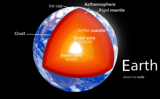
Earth's mantle is a layer of silicate rock between the crust and the outer core. It has a mass of 4.01×1024 kg (8.84×1024 lb) and thus makes up 67% of the mass of Earth. It has a thickness of 2,900 kilometers (1,800 mi) making up about 46% of Earth's radius and 84% of Earth's volume. It is predominantly solid but, on geologic time scales, it behaves as a viscous fluid, sometimes described as having the consistency of caramel. Partial melting of the mantle at mid-ocean ridges produces oceanic crust, and partial melting of the mantle at subduction zones produces continental crust.
Crary Mountains are a group of ice-covered volcanoes in Marie Byrd Land, Antarctica. They consist of two or three shield volcanoes, named Mount Rees, Mount Steere and Mount Frakes, which developed during the course of the Miocene and Pliocene and last erupted about 30,000-40,000 years ago. The first two volcanoes are both heavily incised by cirques, while Mount Frakes is better preserved and has a 4 kilometres (2.5 mi) wide caldera at its summit. Boyd Ridge is another part of the mountain range and lies southeast of Mount Frakes; it might be the emergent part of a platform that underlies the mountain range.
The Integrated Ocean Drilling Program (IODP) was an international marine research program, running from 2003 to 2013. The program used heavy drilling equipment mounted aboard ships to monitor and sample sub-seafloor environments. With this research, the IODP documented environmental change, Earth processes and effects, the biosphere, solid earth cycles, and geodynamics.
Scientific drilling into the Earth is a way for scientists to probe the Earth's sediments, crust, and upper mantle. In addition to rock samples, drilling technology can unearth samples of connate fluids and of the subsurface biosphere, mostly microbial life, preserved in drilled samples. Scientific drilling is carried out on land by the International Continental Scientific Drilling Program (ICDP) and at sea by the Integrated Ocean Drilling Program (IODP). Scientific drilling on the continents includes drilling down into solid ground as well as drilling from small boats on lakes. Sampling thick glaciers and ice sheets to obtain ice cores is related but will not be described further here.
The Glomar Challenger was a deep sea research and scientific drilling vessel for oceanography and marine geology studies. The drillship was designed by Global Marine Inc. specifically for a long term contract with the American National Science Foundation and University of California Scripps Institution of Oceanography and built by Levingston Shipbuilding Company in Orange, Texas. Launched on March 23, 1968, the vessel was owned and operated by the Global Marine Inc. corporation. Glomar Challenger was given its name as a tribute to the accomplishments of the oceanographic survey vessel HMS Challenger. Glomar is a truncation of Global Marine.
Project Mohole was an attempt in the early 1960s to drill through the Earth's crust to obtain samples of the Mohorovičić discontinuity, or Moho, the boundary between the Earth's crust and mantle. The project was intended to provide an earth science complement to the high-profile Space Race. While such a project was not feasible on land, drilling in the open ocean was more feasible, because the mantle lies much closer to the sea floor.
The West Antarctic Rift System is a series of rift valleys between East and West Antarctica. It encompasses the Ross Embayment, the Ross Sea, the area under the Ross Ice Shelf and a part of Marie Byrd Land in West Antarctica, reaching to the base of the Antarctic Peninsula. It has an estimated length of 3,000 km (1,900 mi) and a width of approximately 700 km (430 mi). Its evolution is due to lithospheric thinning of an area of Antarctica that resulted in the demarcation of East and West Antarctica. The scale and evolution of the rift system has been compared to that of the Basin and Range Province of the Western United States.
The riserless research vessel JOIDES Resolution, often referred to as the JR, is one of the scientific drilling ships used by the International Ocean Discovery Program (IODP), an international, multi-drilling platform research program. JOIDES Resolution was previously the main research ship used during the Ocean Drilling Program (ODP) and was used along with the Japanese drilling vessel Chikyu and other mission-specific drilling platforms throughout the Integrated Ocean Drilling Program. She is the successor of Glomar Challenger.
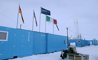
Christina Riesselman is an American paleoceanographer whose research focus is on Southern Ocean response to changing climate.
The DSDP 368 was an area that was drilled as part of the Deep Sea Drilling Project that took place below the Cape Verde Rise.
The DSDP 367 was an area that was drilled as part of the Deep Sea Drilling Project that took place below the Cape Verde Basin.
Bruce Peter Luyendyk is an American geophysicist and oceanographer, currently professor emeritus of marine geophysics at the University of California, Santa Barbara. His work spans marine geology of the major ocean basins, the tectonics of southern California, marine hydrocarbon seeps, and the tectonics and paleoclimate of Antarctica. His research includes tectonic rotations of the California Transverse Ranges, participation in the discovery of deep-sea hydrothermal vents, quantitative studies of marine hydrocarbon seeps, and geologic exploration of the Ford Ranges in Marie Byrd Land, Antarctica.
Horizon Guyot is a presumably Cretaceous guyot (tablemount) in the Mid-Pacific Mountains, Pacific Ocean. It is an elongated ridge, over 300 kilometres (190 mi) long and 4.3 kilometres (2.7 mi) high, that stretches in a northeast-southwest direction and has two flat tops; it rises to a minimum depth of 1,443 metres (4,730 ft). The Mid-Pacific Mountains lie west of Hawaii and northeast of the Line Islands.
Mercer Subglacial Lake is a subglacial lake in Antarctica covered by a sheet of ice 1,067 m (3,501 ft) thick; the water below is hydraulically active, with water replacement times on the order of a decade from the Ross Sea. Studies suggest that Mercer Subglacial Lake as well as other subglacial lakes appear to be linked, with drainage events in one reservoir causing filling and follow-on drainage in adjacent lakes.
Amelia E. Shevenell is an American marine geologist who specializes in high-latitude paleoclimatology and paleoceanography. She is currently a Professor in the College of Marine Science at the University of South Florida. She has made notable contributions to understanding the history of the Antarctic ice sheets and published in high-impact journals and, as a result, was awarded full membership of Sigma Xi. She has a long record of participation in international ocean drilling programs and has served in leadership positions of these organizations. Shevenell served as the elected Geological Oceanography Council Member for The Oceanography Society (2019-2021).
Robert Murray McKay is a paleoceanographer who specialises in sedimentology, stratigraphy and palaeoclimatology, specifically gathering geological evidence to study how marine-based portions of the Antarctic ice sheet behave in response to abrupt climate and oceanic change. He has been involved in examination of marine sedimentary records and glacial deposits to show melting and cooling in Antarctica over the past 65 million years and how this has influenced global sea levels and climate. This has helped climate change scientists overcome uncertainty about how the ice sheets will respond to global warming and how this can be managed effectively in the 21st century. He has participated in international projects including ANDRILL and the International Ocean Discovery Program (IODP), led major New Zealand government-funded research teams and has received several awards in recognition of his work. Since 2023 McKay has been a full professor at Victoria University of Wellington and from 2019, director of the Antarctic Research Centre.
Global paleoclimate indicators are the proxies sensitive to global paleoclimatic environment changes. They are mostly derived from marine sediments. Paleoclimate indicators derived from terrestrial sediments, on the other hand, are commonly influenced by local tectonic movements and paleogeographic variations. Factors governing the earth climate system include plate tectonics, which controls the configuration of continents, the interplay between the atmosphere and the ocean, and the earth's orbital characteristics. Global paleoclimate indicators are established based on the information extracted from the analyses of geologic materials, including biological, geochemical and mineralogical data preserved in marine sediments. Indicators are generally grouped into three categories; paleontological, geochemical and lithological.