Gateholm

Last updated • 3 min readFrom Wikipedia, The Free Encyclopedia

Gateholm
Gateholm 1.JPG
Gateholm from the north-east. Skokholm is in the distance
Pembrokeshire UK location map.svg
Red pog.svg
Gateholm
Geography
Location Marloes
Coordinates 51°43′05″N5°13′53″W / 51.71806°N 5.23139°W / 51.71806; -5.23139
Administration
Wales
County Pembrokeshire
Community Marloes and St Brides

Gateholm or Gateholm Island [1] is a small tidal island off the south west coast of Pembrokeshire, in the community of Marloes and St Brides, [2] [3] in the south west side of Wales, in the west of the UK, and about 8 miles (13 km) west of the port of Milford Haven. It is known for its Romano-British remains. [4] Gateholm is owned by the National Trust as part of their Marloes Sands and Mere estate. [5]

Contents

Name

The name, recorded as Goteholme in 1480, derives from Old Norse for "goat island". [6]

Geography

Gateholm is at the western end of Marloes Sands, and is accessible only at low tide. [7] Gateholm rises to a small plateau 40 metres (131 feet) high, and with an area of about 4 hectares (10 acres). [8] The island consists of steeply-dipping Old Red Sandstone. [9] The rock strata date from the Prídolí Epoch of the Silurian; the exceptional exposure here and on the adjoining Albion Sands have resulted in the location's inclusion in the Geological Conservation Review as a candidate for protection as a geological site of special scientific interest (SSSI).

Gateholm
Invisible Square.svg
Mapscaleline.svg
1km
0.6miles
M
a
r
l
o
e
s
P
e
n
i
n
s
u
l
a
M
a
r
l
o
e
s
S
a
n
d
s
Martin's Haven
Albion Sands
BSicon PARKING.svg
Hooper's Point
Gateholm Island

National Trust and statutory protection

Gateholm was bought by the National Trust in 1981 under Enterprise Neptune, a longterm project to acquire and maintain stretches of coastline to retain its character and preserve its wildlife. The National Trust had already been given over 450 acres on Marloes Peninsula, including Marloes Court Farm, donated in 1941, which included the Marloes Sands and Albion Sands coastline. This, along with adjacent donations of West Hook (1940), Runwayskiln Farm (1941) and Trehill Farm (1942), meant the Trust already owned much of the peninsula and its coast. The acquisition in 1981 of Gateholm plus the Martin's Haven deer park at the western headland, meant the entire coastline and peninsula could be managed under National Trust leases and access arrangements. [5] It is now known as 'Marloes Sands and Mere', and incorporates the Marloes Mere inland SSSI as well as parts of two coastal SSSIs, 'Dale and South Marloes Coast', and 'St Brides Bay South', which between them give legal protection to the whole coastline of the Peninsula. [10] [11] The Gateholm coastline also lies within two European designated areas. The 'Pembrokeshire Marine' Special Area of Conservation is notable for its bays, reefs and grey seals, [12] whilst the Special Protection Area for 'Skomer, Skokholm and the seas off Pembrokeshire', gives protection for the large breeding seabird populations. [13]

Archaeology

The island contained around 130 roundhouses as well as huts of a rectangular shape. The rectangular houses were mostly arranged in rows end-on and surrounded by small courtyards. [14] Excavations of some of these hut sites conducted in 1910 and 1930 found evidence for occupation in the Roman period, with finds including pottery, coins, and a small bronze stag. [8] There was also a bronze pin of Irish origin and dating from the 6th century. [8] One of the houses had a stone phallus buried upright in one of the main post holes. [15] The houses were built of turf with stone facings, the roof being carried on a ridge-pole between the posts. [14] The site has been interpreted variously as a native Romano-British settlement with later occupation, and as an early monastic complex. [14]

Filming

Gateholm was the subject of an episode of the British archaeology television series, Time Team (Series 19, episode 01). The island featured prominently in the 2011 film Snow White and the Huntsman ; a computer-generated castle was superimposed on the island post-production.

Related Research Articles

<span class="mw-page-title-main">Pembrokeshire Coast Path</span> Hiking trail in Wales

The Pembrokeshire Coast Path, often called the Pembrokeshire Coastal Path, is a designated National Trail in Pembrokeshire, southwest Wales. Established in 1970, it is a 186-mile (299 km) long-distance walking route, mostly at cliff-top level, with a total of 35,000 feet (11,000 m) of ascent and descent. At its highest point – Pen yr afr, on Cemaes Head – it reaches a height of 574 feet (175 m), and at its lowest point – Sandy Haven crossing, near Milford Haven – it is just 6 feet (2 m) above low water. Whilst most of the coastline faces west, it offers – at varying points – coastal views in every direction of the compass.

<span class="mw-page-title-main">Pembrokeshire Coast National Park</span> National park in Wales

Pembrokeshire Coast National Park is a national park along the Pembrokeshire coast in west Wales.

<span class="mw-page-title-main">Skokholm</span> Small island in Wales

Skokholm or Skokholm Island is an island 2.5 miles (4.0 km) off the coast of Pembrokeshire, Wales, south of the neighbouring island of Skomer. The surrounding waters are a marine reserve and all are part of the Pembrokeshire Coast National Park. Both islands are listed as Sites of Special Scientific Interest.

<span class="mw-page-title-main">Skomer</span> Island in Pembrokeshire, Marloes and St Brides, Wales

Skomer or Skomer Island is an island off the coast of Pembrokeshire, in the community of Marloes and St Brides in west Wales. It is well known for its wildlife: around half the world's population of Manx shearwaters nest on the island, the Atlantic puffin colony is the largest in southern Britain, and the Skomer vole is unique to the island. Skomer is a national nature reserve, a Site of Special Scientific Interest and a Special Protection Area. It is surrounded by a marine nature reserve and is managed by the Wildlife Trust of South and West Wales.

<span class="mw-page-title-main">Middleholm</span> Island in Pembrokeshire, Wales

Middleholm, also known as Midland Isle, is a small island lying off southwest Pembrokeshire in Wales, between the island of Skomer and the mainland in the community of Marloes and St Brides. It is roughly circular with a diameter of about 1,210 feet (370 m) and an area of 21.5 acres (8.7 ha). It is separated from the mainland by Jack Sound and from Skomer by Little Sound.

<span class="mw-page-title-main">St Brides Bay</span>

St Brides Bay is a bay in western Pembrokeshire, West Wales.

<span class="mw-page-title-main">Marloes</span> Village and parish in Pembrokeshire, Wales

Marloes is a village and parish in Pembrokeshire, Wales, on the Marloes Peninsula 7 miles (11 km) west of Milford Haven and forms the western tip of the southern shore of St Brides Bay. It is within part of the Pembrokeshire Coast National Park. The parish has 6 miles (9.7 km) of mainland coastline accessible throughout by the Pembrokeshire Coast Path and, together with St Brides, constitutes the community of Marloes and St Brides. In 2001, the population was 323.

<span class="mw-page-title-main">Wildlife Trust of South and West Wales</span> Wildlife Trust in Wales

The Wildlife Trust of South and West Wales (WTSWW) is a Wildlife Trust in south and west Wales, one of 46 such Trusts in the United Kingdom.

<span class="mw-page-title-main">Ronald Lockley</span> Welsh ornithologist and naturalist

Ronald Mathias Lockley was a Welsh ornithologist and naturalist. He wrote over fifty books on natural history, including a study of shearwaters, and the book The Private Life of the Rabbit, which was used in the development of his friend Richard Adams's children's book Watership Down.

<span class="mw-page-title-main">Marloes and St Brides</span> Community in Pembrokeshire, Wales

Marloes and St. Brides is a community in the West Wales county of Pembrokeshire. It lies on the Pembrokeshire Coast Path and in the Pembrokeshire Coast National Park.

<span class="mw-page-title-main">Skomer Marine Conservation Zone</span>

Skomer Marine Conservation Zone is an underwater marine nature reserve located off the coast of Pembrokeshire in Wales. The nature reserve completely surrounds the islands of Skomer and Middleholm, and encompasses the mainland coastline around the end of the Marloes peninsula, including the small bay of Martin's Haven.

<span class="mw-page-title-main">Martin's Haven</span> Bay in Pembrokeshire, Wales, UK,

Martin's Haven is a small bay in Pembrokeshire, Wales, UK, on the Dale Peninsula, with views across St Bride's Bay towards St David's. Its shingle beach has a stone slipway which acts as an embarkation point for the ferry which visits the nearby island of Skomer, a national nature reserve, during summer. Martin's Haven lies within the Skomer Marine Conservation Zone and is popular for scuba diving. Grey seals can be seen basking on the rocks. The land is owned by the National Trust.

The Sea Empress oil spill occurred at the entrance to the Milford Haven Waterway in Pembrokeshire, Wales on 15th February 1996. The Sea Empress was en route to the Texaco oil refinery near Pembroke when she became grounded on mid-channel rocks at St. Ann's Head. Over the course of a week, she spilt 72,000 tons of crude oil into the sea. The spill occurred within the Pembrokeshire Coast National Park – one of Europe's most important and sensitive wildlife and marine conservation areas. It was Britain's third largest oil spillage and the twelfth largest in the world at the time.

<span class="mw-page-title-main">Protected areas of Wales</span> Designated area for protection in Wales

Wales, a country that is part of the United Kingdom, contains protected areas under various designations. The largest designation by land area is Wales' three national parks, followed by the five Areas of Outstanding Natural Beauty.

<span class="mw-page-title-main">Marloes Sands</span> Beach in Wales

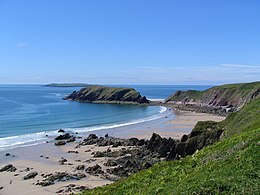
Marloes Sands is an approx. 1.5 kilometres (0.93 mi) long remote sandy beach in Pembrokeshire, Wales, near the village of Marloes. It's broadly curved and surrounded by cliffs. Walking on the beach gives great views of Skokholm Island and Gateholm Island.

Marloes Mere is a Site of Special Scientific Interest in Pembrokeshire, South Wales. It has been designated as a Site of Special Scientific Interest since November 1985 in an attempt to protect its fragile biological elements. The site has an area of 17.17 hectares and is managed by Natural Resources Wales.

<span class="mw-page-title-main">Coastline of Wales</span> Sea-bounded areas of Wales

The coastline of Wales extends from the English border at Chepstow westwards to Pembrokeshire then north to Anglesey and back eastwards to the English border once again near Flint. Its character is determined by multiple factors, including the local geology and geological processes active during and subsequent to the last ice age, its relative exposure to or shelter from waves, tidal variation and the history of human settlement and development which varies considerably from one place to another. The majority of the coast east of Cardiff in the south, and of Llandudno in the north, is flat whilst that to the west is more typically backed by cliffs. The cliffs are a mix of sandstones, shales and limestones, the erosion of which provides material for beach deposits. Of the twenty-two principal areas which deliver local government in Wales, sixteen have a coastline, though that of Powys consists only of a short section of tidal river some distance from the open sea. Its length has been estimated at 1,680 miles (2,700 km).

The geology of Pembrokeshire in Wales inevitably includes the geology of the Pembrokeshire Coast National Park which extends around the larger part of the county's coastline and where the majority of rock outcrops are to be seen. Pembrokeshire's bedrock geology is largely formed from a sequence of sedimentary and igneous rocks originating during the late Precambrian and the Palaeozoic era, namely the Ediacaran, Cambrian, Ordovician, Silurian, Devonian and Carboniferous periods, i.e. between 635 and 299 Ma. The older rocks in the north of the county display patterns of faulting and folding associated with the Caledonian Orogeny. On the other hand, the late Palaeozoic rocks to the south owe their fold patterns and deformation to the later Variscan Orogeny.

References

  1. "Gateholm Island". Ordnance Survey . Retrieved 7 February 2019.
  2. "Marloes and St. Brides". Office for National Statistics. Retrieved 16 November 2018.
  3. Ordnance Survey mapping
  4. Gateholm Island at the Megalithic Portal
  5. 1 2 National Trust web page for Marloes Sands and Mere . See also interactive maps of NT property ownership.
  6. "Gateholm" entry in Anthony David Mills, (2003), Oxford dictionary of British place names. Oxford University Press
  7. Mike Parker, Paul Whitfield, (2003), Rough guide to Wales, page 196. Rough guides
  8. 1 2 3 John Buxton, Ronald Mathias Lockley, (1950), Island of Skomer:a preliminary survey of the natural history of Skomer Island, Pembrokeshire, page 16. Staples Press
  9. Eric C. F. Bird, (2010), Encyclopedia of the World's Coastal Landforms: Volume 1, page 376. Springer
  10. "SSSI Citation 0585 for Dale and South Marloes Coast" (PDF). Natural Resources Wales. 2002.
  11. "SSSI Citation 0342 for St Bride's Bay South" (PDF). Natural Resources Wales. 2002.
  12. "SAC Citation UK0013116 for Pembrokeshire Marine" (PDF). Natural Resources Wales. 2004.
  13. "SPA Citation UK9014051 for Skomer, Skokholm and the seas off Pembrokeshire" (PDF). Natural Resources Wales. 1996. Archived from the original (PDF) on 4 December 2019. Retrieved 4 December 2019.
  14. 1 2 3 Lloyd Robert Laing (1975), The Archaeology of Late Celtic Britain and Ireland, c. 400-1200 AD, page 111. Methuen
  15. Thomas Charles Lethbridge, (1948), Merlin's Island: essays on Britain in the Dark Ages, page 81. Methuen

51°43′05″N5°13′53″W / 51.71813°N 5.23125°W / 51.71813; -5.23125