Lydstep Haven

Last updated

Lydstep Haven
Lydstep Haven, Near Tenby - geograph.org.uk - 55493.jpg
Lydstep Haven
Pembrokeshire UK location map.svg
Red pog.svg
Lydstep Haven
Location within Pembrokeshire
Principal area
Ceremonial county
Country Wales
Sovereign state United Kingdom
Post town TENBY
Postcode district SA
Police Dyfed-Powys
Fire Mid and West Wales
Ambulance Welsh
UK Parliament
List of places
UK
Wales
Pembrokeshire
51°39′02″N4°46′02″W / 51.650556°N 4.767222°W / 51.650556; -4.767222 Coordinates: 51°39′02″N4°46′02″W / 51.650556°N 4.767222°W / 51.650556; -4.767222

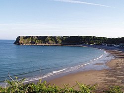
Lydstep Haven, known in ancient times as Lis Castell, is an area in Pembrokeshire, Wales, in the community of Manorbier. Both the beach and caravan park are what is known as Lydstep Haven. Reached via the A4139 from Tenby and Pembroke. [1]

The hamlet of Lydstep contains the Grade I listed ruins of a "Bishop's Palace" across from the road from the Lydstep Tavern. Although called a palace, it is understood to have been the hunting seat of Lord St David in the early 14th century. Cadw describe it as a medieval house containing a first-floor hall and possible parlour, and vaulted undercroft in two unequal sections, constructed of limestone masonry with slate roof. Traditionally known as the 'Place of Arms', its name perhaps became mutated to 'palace' and was probably where the manorial court of Manorbier and Penally was held. [2]

Related Research Articles

Pembrokeshire Coast Path

The Pembrokeshire Coast Path, often called the Pembrokeshire Coastal Path, is a designated National Trail in Pembrokeshire, southwest Wales. Established in 1970, it is a 186-mile (299 km) long-distance walking route, mostly at cliff-top level, with a total of 35,000 feet (11,000 m) of ascent and descent. At its highest point – Pen yr afr, on Cemaes Head – it reaches a height of 574 feet (175 m), and at its lowest point – Sandy Haven crossing, near Milford Haven – it is just 6 feet (2 m) above low water. Whilst most of the coastline faces west, it offers – at varying points – coastal views in every direction of the compass.

Manorbier Village and parish in Pembrokeshire, Wales

Manorbier is a village, community and parish on the south coast of Pembrokeshire, Wales. The name means the 'Manor of Pŷr'. The community includes Jeffreyston and Lydstep.

Manorbier Castle

Manorbier Castle is a Norman castle in Manorbier, 5 miles (8.0 km) southwest of Tenby, Wales. It was founded in the late 11th century by the Anglo-Norman de Barry family. The castle was part of a mesne lordship under the control of the medieval Earls of Pembroke.

Manorbier railway station Railway station in Pembrokeshire, Wales

Manorbier railway station is in Pembrokeshire, Wales, on the Pembroke Dock branch of the West Wales Line is operated by Transport for Wales Rail, who also manage the station. It is 1 mile (1.6 km) north of Manorbier in the triangle completed by Jameston and St. Florence. Trains stop here on request every two hours in each direction, westwards to Pembroke Dock and eastwards to Tenby, Whitland, Carmarthen and Swansea.

de Barry family

The de Barry family is a noble family of Cambro-Norman origins which held extensive land holdings in Wales and Ireland. The founder of the family was a Norman Knight, Odo, who assisted in the Norman Conquest of England during the 11th century. As reward for his military services, Odo was granted estates in Pembrokeshire and around Barry, Wales, including Barry Island just off the coast.

Haven Holidays

Haven Holidays is a chain of holiday parks in the United Kingdom. It operates caravan, touring and camping facilities across 40 sites in the UK in predominantly coastal locations.

Pembroke River is a short waterway near Pembroke, Pembrokeshire, West Wales.

RAF Manorbier

RAF Manorbier was a Royal Air Force airfield near Manorbier, Pembrokeshire, Wales. The site was first used in 1933 as a mixed civilian/military airfield and was the base for ‘Y’ Flight of No. 1 Anti-Aircraft Co-operation Unit RAF in 1937, using de Havilland DH.82 Queen Bee unmanned radio-controlled target drone.

Lawrenny Human settlement in Wales

Lawrenny is a village and parish in the community and electoral ward of Martletwy, in the county of Pembrokeshire, Wales. It is on a peninsula of the River Cleddau estuary upriver from Milford Haven where it branches off towards the Cresswell and Carew Rivers and is in the Pembrokeshire Coast National Park.

The Welsh Premier League is the top level women's football league in Wales. It was founded in 2009.

Lydstep Palace

Lydstep Palace is a ruinous medieval hall house in the hamlet of Lydstep, Pembrokeshire, Wales.

Jameston Human settlement in Wales

Jameston is a village in the parish and community of Manorbier, south Pembrokeshire, Wales, 1 mile (1.6 km) northwest of Manorbier. The population in 2011 was 634.

St Jamess Church, Manorbier Church in Wales

St James's Church, Manorbier is a Grade I-listed parish church in Manorbier, Pembrokeshire, Wales. The church dates from the 12th century, and has been considerably altered over the years, though medieval ceiling paintings in the porch survive. The church has a slender tower of the local type and a bellcote. The chancel was built in about 1250 on older foundations with the transepts added in the same period.

The Pembrokeshire League is a football league in Pembrokeshire, West Wales, running from levels five to nine of the Welsh football league system.

References

  1. Dalton, Nick; Stone, Deborah (30 December 2008). Frommer's Wales With Your Family: From Cliff-top Castles to Sandy Coves. Frommer's. p. 131. ISBN   978-0-470-72320-3 . Retrieved 23 April 2011.
  2. "Lydstep Palace, Manorbier". British Listed Buildings. Retrieved 1 January 2014.