
Pembrokeshire is a county in the south-west of Wales. It is bordered by Carmarthenshire to the east, Ceredigion to the northeast, and the rest by sea. The county is home to Pembrokeshire Coast National Park, the only national park in the United Kingdom established primarily because of the coastline; the Park occupies more than a third of the area of the county and includes the Preseli Hills in the north as well as the 190-mile (310 km) Pembrokeshire Coast Path.

Pembroke is a town in Pembrokeshire, Wales. It is both a community and one of the larger towns in the county with a population of 7,552. The names of both the town and the county have a common origin; both are derived from the Cantref of Penfro: Pen = "head" or "end", and bro = "region", "country", "land", which has been interpreted to mean either "Land's End" or "headland".

The Preseli Hills or, as they are known locally and historically, Preseli Mountains is a range of hills in north Pembrokeshire, west Wales, mostly within the Pembrokeshire Coast National Park.

South Pembrokeshire was one of six local government districts of Dyfed, Wales from 1974 to 1996.

Wolfscastle, also spelt Wolf's Castle, is a village and community in Pembrokeshire, between Haverfordwest and Fishguard, in southwest Wales. It was historically in the parish of St Dogwells.

Narberth is both a town and a community in Pembrokeshire, Wales. It was founded around a Welsh court and later became a Norman stronghold on the Landsker Line. It became the headquarters of the hundred of Narberth. It was once a marcher borough. George Owen described it in 1603 as one of nine Pembrokeshire "boroughs in decay".

Saundersfoot is a large village, community and electoral ward in Pembrokeshire, Wales. It is near Tenby, both being holiday destinations. Saundersfoot lies in the Pembrokeshire Coast National Park and on the Pembrokeshire Coast Path. The village population was 3,361 in 2011.

Clynderwen is a rural linear village and community, historically in Carmarthenshire in Wales, but administered as part of Pembrokeshire. It lies on the A478 Tenby to Cardigan road south of the village of Llandissilio and north of the town of Narberth.
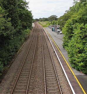
Clunderwen railway station serves the village of Clynderwen in Pembrokeshire, Wales. The station is unmanned. It is a request stop.
Rosebush is a small village in the community of Maenclochog, Pembrokeshire, southwest Wales, UK. It lies in the southern slopes of the Preseli Hills, about 1 mile (1.6 km) north west of the village of Maenclochog. Slate was extensively quarried nearby, and was exported by the Narberth Road and Maenclochog Railway, which was later extended towards Fishguard. Today, Rosebush is a centre for exploring the Preseli Hills.

Carew is a village, parish and community on an inlet of Milford Haven in the former Hundred of Narberth, Pembrokeshire, West Wales, 4 miles (6.4 km) east of Pembroke. The eastern part of the parish is in the Pembrokeshire Coast National Park.
Ysgol Y Preseli is a Welsh comprehensive 11-18 school in the village of Crymych, Pembrokeshire, Wales.

The North Pembrokeshire and Fishguard Railway was a railway company in south-west Wales, incorporated to extend the moribund Narberth Road and Maenclochog Railway, with a view to developing a port on Fishguard Bay and ferry services to Rosslare in Ireland.

Ysgol Bro Gwaun is a secondary comprehensive school in the town of Fishguard in north Pembrokeshire. It is a predominantly English-medium school with significant use of Welsh, and has a catchment area covering the towns of Fishguard and Goodwick, the villages of Scleddau, Letterston and Newport and the surrounding areas including the Gwaun valley.
Llandeilo Llwydarth or Llandilo is an ancient area and parish in the Preseli Hills between Llangolman and Maenclochog in the community of Maenclochog, Pembrokeshire, Wales.

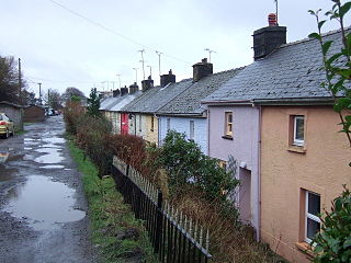
Llandissilio is a village and parish in the community of Llandissilio West in east Pembrokeshire, Wales on the A478 road between Efailwen to the north and Clunderwen to the south. A largely ribbon development along the main road, the village is surrounded by farmland.

Tegryn is a hilltop linear village in north Pembrokeshire, Wales, in the community and parish of Clydau and is the largest settlement in the community.
Llanycefn railway station, also known as Llan-y-cefn railway station, served the village of Maenclochog, Pembrokeshire, Wales, from 1876 to 1949 on the Narberth Road and Maenclochog Railway.
Rosebush railway station served the village of Rosebush, Pembrokeshire, Wales, from 1876 to 1949 on the Narberth Road and Maenclochog Railway.


