Nevern

Last updated • 4 min readFrom Wikipedia, The Free Encyclopedia

Nevern
NevernChurchSW.jpg
St Brynach's Church
Pembrokeshire UK location map.svg
Red pog.svg
Nevern
Location within Pembrokeshire
Population865 (2011) [1]
OS grid reference SN082400
Community
  • Nevern
Principal area
Country Wales
Sovereign state United Kingdom
Post town Newport
Postcode district SA42 0
Dialling code 01239
Police Dyfed-Powys
Fire Mid and West Wales
Ambulance Welsh
UK Parliament
Senedd Cymru – Welsh Parliament
List of places
UK
Wales
Pembrokeshire

52°01′N4°48′W / 52.02°N 4.80°W / 52.02; -4.80

Contents

2024 Wales Pembrokeshire Community Nevern map.svg
Map of the community

Nevern (Welsh : Nanhyfer) is both a parish and a community in Pembrokeshire, Wales. The community includes the settlements of Felindre Farchog, Monington, Moylgrove and Bayvil. The small village lies in the Nevern valley near the Preseli Hills of the Pembrokeshire Coast National Park 2 miles (3 km) east of Newport on the B4582 road.

History

Neolithic

The area around Nevern has been occupied since at least neolithic times (about 4,000 years ago); evidence includes barrows revealed in an aerial survey during the 2018 heatwave. [2]

Norman rule

When the ruler of Deheubarth, Rhys ap Tewdwr, died in battle and his lands were forfeited to the Normans, Martin de Turribus became the Marcher Lord of Kemes, with his caput at Nevern, where he took over an existing fortification. [3] [4] [5]

Norman castle

The early 12th century Nevern Castle stood on a spur of the hill northwest of the church. [6] Under Martin's son, Robert fitz Martin, it was the only Norman castle to successfully resist the forces of Rhys ap Gruffydd's sons, who were trying to re-establish Deheubarth. Robert's son William later established peace with Rhys ap Gruffydd by marrying his daughter, Angharad. The castle changed hands several times over the following 80 years, and was eventually destroyed by Hywel Sais in 1195. In 1197, Robert and Angharad's son, William Fitz Martin founded Newport, and built a castle there, abandoning Nevern. [7] In modern times little remains of the castle, but the site has been extensively excavated. It was probably a square building with a bastion at each corner, [4] and may have been one of the earliest stone castles built in Wales. [8]

Land ownership

Although the local area is not mentioned, an allegorical poem in the 13th century Black Book of Carmarthen [9] has been extrapolated by some writers to conclude that the area must have once been under the rule of Cuhelyn the Bard  [ cy ], [10] a descendant of whom was later granted land in the nearby Preseli Hills by charter. [11] [12]

In 1603, the antiquarian George Owen, Lord of Cemais, described Nevern as one of nine Pembrokeshire "boroughs in decay". [13]

Nevern Bridge

Nevern Bridge spans the River Nevern in the centre of the village. The current bridge was built in the late 18th or early 19th century and is a Grade II listed structure. It has two unequal arches, recessed with keystones. [14]

Parish

The parish of Nevern and its Quarters NevernQuarters.jpg
The parish of Nevern and its Quarters
Nevern's 10th century Celtic cross NevernCross.jpg
Nevern's 10th century Celtic cross

The parish of Nevern was the largest in Pembrokeshire at 5,963 hectares (14,730 acres), and was divided into four "quarters": Crugiau, Morfa, Trewern and Cilgwyn. Cilgwyn extends to the south side of the Preseli Hills; a 1578 map in the British Library shows Kilgwin as a separate parish, and also Neverne, but the other quarters are not shown. [15] Before becoming a quarter of Nevern parish, Cilgwyn was reduced from a parish to a chapelry, dedicated to St Mary. [16] Nevern parish church (see below) is in Crugiau Quarter.

In 1833 the population of the parish, at 1,558 inhabitants, was nearly twice that of 2011. [17] [18] Nevern is slightly more than 2 miles (3.2 km) from Newport, Pembrokeshire.

Parish Church

The Norman Church of St Brynach [19] is on the site of St Brynach's 6th century "clas", an important ecclesiastical centre. At the time when it is said that Dyfed had seven bishops, this was probably the seat of one. Except for the castellated tower, perilously undercut by the adjacent river Caman, most of the original Norman structure of the present building has been rebuilt. The church and churchyard are remarkable for the Celtic Cross, several inscribed stones and an avenue of yew trees. The church is a Grade II* listed building, [20] as are more than 60 other listed buildings in the community. [21] The churchyard is designated at Grade II on the Cadw/ICOMOS Register of Parks and Gardens of Special Historic Interest in Wales. [22]

In the churchyard is a "bleeding yew" that leaks red sap at certain times of the year. [23] George Owen is buried here, and is commemorated by a plaque in the Henllys Chapel behind the organ.

Historical remains

(left) the Maglocunus Stone, (centre) the Vitalianus Stone, (right) the braided cross NevernStones.jpg
(left) the Maglocunus Stone, (centre) the Vitalianus Stone, (right) the braided cross

The Nevern Cross on the south side of the church dates from the 10th century or early 11th century. It consists of two sections fitted together with a mortice and tenon joint, both cut from the local dolerite stone. It has classic braided decorations and inscriptions reading "dns" on one side and "h.an.eh" on the other. Nearby is the Vitalianus Stone, dating from around 500 AD, inscribed in Latin "VITALIANI EMERTO" and in Ogham "vitaliani". In the Trewern Chapel in the south transept, two inscribed stones are set into the window sills. The Maglocunus Stone is inscribed in Latin "MAGLOCUNI FILI CLUTORI" and in Ogham "maglicunas maqi clutar.." and is of the 5th century or early 6th century. The Braided Cross is of the early 10th century. There is a Pilgrim's Cross cut into the rock on the roadside between the village and the castle. Dyfed Archaeological Trust has carried out excavations at the castle site. [24] The Pentre Ifan dolmen and the Castell Henllys hillfort are in the parish, each about 2 miles (3.2 km) from the village. The dolmen [25] is under the care of Cadw, the Welsh Historic Monuments Agency. [26]

Notable people

Related Research Articles

<span class="mw-page-title-main">Newport, Pembrokeshire</span> Town, parish and community in Pembrokeshire, Wales

Newport is a town, community, electoral ward and ancient port of Parrog, on the Pembrokeshire coast in West Wales at the mouth of the River Nevern in the Pembrokeshire Coast National Park. The town gives its name to Newport Bay.

<span class="mw-page-title-main">Preseli Mountains</span> Hill range in Wales

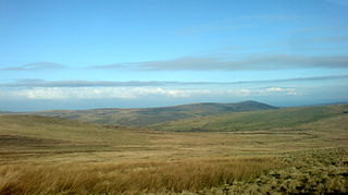
The Preseli Mountains, also known as the Preseli Hills, or just the Preselis, is a range of hills in western Wales, mostly within the Pembrokeshire Coast National Park and entirely within the county of Pembrokeshire.

<span class="mw-page-title-main">St Dogmaels</span> Village, parish and community in Pembrokeshire, Wales

St Dogmaels is a village, parish and community in Pembrokeshire, Wales, on the estuary of the River Teifi, a mile downstream from the town of Cardigan in neighbouring Ceredigion. A little to the north of the village, further along the estuary, lies Poppit Sands beach. The parish includes the small settlement of Cippyn, south of Cemaes Head.

<span class="mw-page-title-main">Wiston, Pembrokeshire</span> Village, parish and community in Pembrokeshire, Wales

Wiston is a village, parish and community in Pembrokeshire, Wales, in the United Kingdom. It was once a marcher borough. George Owen, in 1603, described it as one of nine Pembrokeshire "boroughs in decay". It continued as a constituent parliamentary borough until the end of the 19th century.

<span class="mw-page-title-main">Dinas Cross</span> Village and community in Pembrokeshire, Wales

Dinas Cross is a village, a community and a former parish in Pembrokeshire, Wales. Located between Fishguard and Newport in the Pembrokeshire Coast National Park, it is a popular holiday destination on the A487 road. The two hamlets, Cwm-yr-Eglwys and Pwllgwaelod, are in the community. The community has an elected community council and until 2022 gave its name to an electoral ward of Pembrokeshire County Council which covered the communities of Dinas Cross, Cwm Gwaun and Puncheston.

<span class="mw-page-title-main">Carew, Pembrokeshire</span> Village, parish and community in Pembrokeshire, Wales

Carew is a village, parish and community on an inlet of Milford Haven in the former Hundred of Narberth, Pembrokeshire, West Wales, 4 miles (6.4 km) east of Pembroke. The eastern part of the parish is in the Pembrokeshire Coast National Park.

<span class="mw-page-title-main">Llawhaden</span> Village, parish and community in Pembrokeshire, Wales

Llawhaden is a village, parish and community in mid-Pembrokeshire, West Wales, historically in the Hundred of Dungleddy. The community of Llawhaden includes the parish of Robeston Wathen, part of Narberth and the hamlet of Gelli, and had a population of 634 in 2001, increasing to 688 at the 2011 Census.

<span class="mw-page-title-main">Eglwyswrw</span> Village, parish and community in Pembrokeshire, Wales

Eglwyswrw ( ) is a village, community and parish in the former Cantref of Cemais, Pembrokeshire, Wales. The village lies between Newport and Cardigan at the junction of the A487 road and the B4332 at an altitude of 130 metres (430 ft).

<span class="mw-page-title-main">Pentre Ifan</span> Neolithic dolmen in Pembrokeshire, Wales

Pentre Ifan is the name of an ancient manor in the community and parish of Nevern, Pembrokeshire, Wales. It is 11 miles (18 km) from Cardigan, Ceredigion, and 3 miles (4.8 km) east of Newport, Pembrokeshire. It contains and gives its name to the largest and best preserved neolithic dolmen in Wales.

<span class="mw-page-title-main">Cemais (Dyfed)</span> Welsh medieval cantref

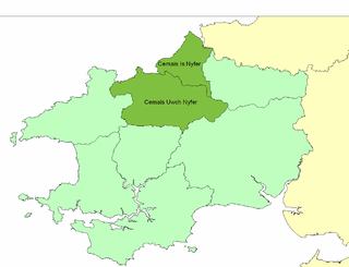
Cemais was an ancient cantref of the Kingdom of Dyfed, from the 11th century a Norman Marcher Lordship, from the 16th century a Hundred, and is now part of Pembrokeshire, Wales. It occupied the coastal area between the Teifi estuary and Fishguard, and the northern and southern slopes of the Preseli Hills, covering an area of approximately 140 square miles (360 km2). The Afon Nyfer divided it into two commotes: Cemais Is Nyfer to the north and Cemais Uwch Nyfer to the south.

<span class="mw-page-title-main">Felindre Farchog</span> Village in Pembrokeshire, Wales

Felindre Farchog is a small village in the community of Nevern in Pembrokeshire, Wales, located around 7 miles (11 km) south-west of Cardigan, and within the parish of Bayvil. The A487 road from Cardigan to Newport runs through the village.

Carew Cross is an 11th-century Grade I listed monument in the village of Carew, Pembrokeshire, Wales.

<span class="mw-page-title-main">Newport Castle, Pembrokeshire</span>

Newport Castle is a castle located in Newport, Pembrokeshire, Wales. The earliest castle on the site was built in the 13th century, and the present structure was built in the 19th century and is a private residence.

<span class="mw-page-title-main">B4329 road</span> Road in Wales

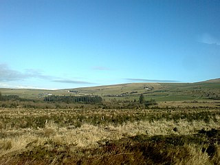
The B4329 is a scenic route and a former turnpike in Pembrokeshire, West Wales. It links Eglwyswrw in the north of the county to Haverfordwest, the county town in the south, in an approximately southwesterly direction, crossing the Preseli Mountains. It links to the A487 trunk road at both its northern and southern ends.

<span class="mw-page-title-main">Pontfaen</span> Village and parish in Pembrokeshire, Wales

Pontfaen is a small rural village and parish in the community of Cwm Gwaun, north Pembrokeshire, Wales. It is 3 miles (4.8 km) southeast of the port of Fishguard.

<span class="mw-page-title-main">Meline, Pembrokeshire</span> Parish in Pembrokeshire, Wales

Meline is a parish in the Diocese of St David's in north Pembrokeshire, Wales. There is no settlement of this name.

<span class="mw-page-title-main">Monington, Pembrokeshire</span> Village and parish in Pembrokeshire, Wales

Monington is a small settlement and parish in the community of Nevern, north Pembrokeshire, Wales. It is on the Nant Ceibwr that flows through Moylegrove and into Ceibwr Bay. Part of the parish lies within the Pembrokeshire Coast National Park.

<span class="mw-page-title-main">Brynberian</span> Village in Pembrokeshire, Wales

Brynberian is a small village in north Pembrokeshire, Wales, in the foothills of the Preseli Mountains in the Pembrokeshire Coast National Park. It is in the community of Eglwyswrw and the parish of Nevern, and is on the B4329 road between Crosswell and Tafarn y Bwlch. Afon Brynberian flows through the village under an ancient bridge and joins the River Nevern to the north.

<span class="mw-page-title-main">Morvil</span> Parish in Pembrokeshire, Wales

Morvil or Morfil is a remote upland parish on the southern slopes of the Preseli Mountains in north Pembrokeshire, Wales. Fishguard is 6 miles (10 km) to the northwest. The area was occupied in neolithic and Norman times, and in the past two centuries has been sparsely populated with no significant settlements developing. The parish church is dedicated to St John the Baptist.

Pentre Galar is a small settlement in the Preseli Mountains south of the village of Crymych, north Pembrokeshire, Wales, on the A478 Cardigan to Tenby road. The western part of the settlement lies in the parish of Mynachlog-ddu and the eastern part in Llanfyrnach parish.

References

  1. "Constituency population 2011" . Retrieved 21 April 2015.
  2. "Heatwave crop marks reveal 200 ancient sites in Wales". BBC News. 28 December 2018. Retrieved 29 December 2018.
  3. The history of Wales, descriptive of the government, wars, manners, religion, laws, druids, bards, pedigrees and language of the ancient Britons and modern Welsh, and of the remaining antiquities of the principality, John Jones, 1824, London, p. 63-64
  4. 1 2 Laws, Edward (1888). The History of Little England Beyond Wales. Bell, London. p. 98. Retrieved 21 January 2019.
  5. The ancient castles of England and Wales, William Woolnoth, 1825, entry for Newport
  6. Lewis, S. (1833). Topographical Dictionary of Wales . Retrieved 16 January 2019.
  7. Edwards, Emily Hewlett (1909). Castles and Strongholds of Pembrokeshire. J. E. Arnett. p. 12.
  8. "Nevern Castle (304392)". Coflein. RCAHMW . Retrieved 29 September 2021.
  9. "The Ode of Cyridwen". Archived from the original on 8 June 2011. Retrieved 14 January 2019.
  10. A poem in praise of Cuhelyn Fardd in the Black Book of Carmarthen, R.G. Gruffydd, in Studia Celtica 10/11, University of Wales Press, 1975,
  11. Baronia de Kemeys. From the original documents at Bronwydd., Sir Thomas Davies Lloyd (Bt.), London, 1862, p.48
  12. An Inventory of the Ancient Monuments in Wales and Monmouthshire, Royal Commission on the Ancient and Historical Monuments of Wales, 1914, Volume 4, p 276
  13. Owen, George, The Description of Penbrokshire by George Owen of Henllys Lord of Kemes, Henry Owen (Ed), London, 1892
  14. "British Listed Buildings" . Retrieved 23 March 2016.
  15. "Penbrok comitat". British Library. Retrieved 22 July 2024.
  16. "GENUKI: Cilgwyn" . Retrieved 22 August 2019.
  17. "GENUKI: Nevern" . Retrieved 23 March 2016.
  18. "GENUKI: Nevern parish maps 22 & 22a" . Retrieved 29 July 2019.
  19. "St Brynach, Nevern" . Retrieved 17 January 2019.
  20. Cadw. "Church of St Brynach (Grade II*) (12746)". National Historic Assets of Wales. Retrieved 29 July 2019.
  21. "British Listed Buildings: Nevern" . Retrieved 17 January 2019.
  22. Cadw. "St Brynach's Churchyard, Nevern (PGW(Dy)67(PEM))". National Historic Assets of Wales. Retrieved 6 February 2023.
  23. "Pembrokeshire Virtual Museum: St Brynach's Church (Nevern)" . Retrieved 23 March 2016.
  24. "Dyfed Archaeological Trust: Nevern Castle Project" . Retrieved 23 March 2016.
  25. "Pentre Ifan Chambered Tomb, Near Nevern (101450)". Coflein. RCAHMW. Retrieved 29 September 2021.
  26. "Cadw: Pentre Ifan Burial Chamber" . Retrieved 17 January 2019.
  27. Thomas, Daniel Lleufer (1895). "Owen, George (1552-1613)"  . Dictionary of National Biography . Vol. 42. p. 408-410.
  28. Thomas, Daniel Lleufer (1895). "Owen, George (d.1665)"  . Dictionary of National Biography . Vol. 42. p. 410-412.
  29. Buckland, Augustus (1891). "Hughes, Joshua"  . Dictionary of National Biography . Vol. 28. pp. 183–184.

Further reading

Dillwyn Miles, A Book on Nevern, Gomer, 1998, ISBN   1-85902-578-1