Castell Henllys

Last updated

Castell Henllys Iron Age Fort
Castell Henllys - geograph.org.uk - 67364.jpg
Wales location map.svg
Red pog.svg
Location within Wales
Coordinates 52°01′01″N4°44′42″W / 52.017°N 4.745°W / 52.017; -4.745
Type Archaeological open-air museum
Website Castell Henllys

Castell Henllys (Welsh, "castle of the old court") is an archaeological site near Nevern in north Pembrokeshire, Wales.

Contents

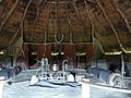
The Iron Age hillfort has been the subject of an ongoing excavation since the start of the 21st century, accompanied by an exercise in reconstruction archaeology whereby experiments in prehistoric farming have been practised. Four roundhouses and a granary have been reconstructed on their original Iron Age foundations – some 2,000 years old – the hillfort the only site in Britain where this has been done. [1] The Castell Henllys site includes significant earthworks and fortifications. [2]

During the summer the site provides training for young archaeologists and is a popular visitor attraction. [3] It is owned by Pembrokeshire Coast National Park.

See also

Related Research Articles

<span class="mw-page-title-main">Hillfort</span> Type of earthworks used as a fortified refuge or defended settlement

A hillfort is a type of earthwork used as a fortified refuge or defended settlement, located to exploit a rise in elevation for defensive advantage. They are typically European and of the Bronze Age or Iron Age. Some were used in the post-Roman period. The fortification usually follows the contours of a hill and consists of one or more lines of earthworks, with stockades or defensive walls, and external ditches. If enemies were approaching, the civilians would spot them from a mile away.

<span class="mw-page-title-main">Barbury Castle</span> Hillfort in Wiltshire, England

Barbury Castle is a scheduled hillfort in Wiltshire, England. It is one of several such forts found along the ancient Ridgeway route. The site, which lies within the Wessex Downs Area of Outstanding Natural Beauty, has been managed as a country park by Swindon Borough Council since 1971. It is on Barbury Hill, a local vantage point, which, under ideal weather conditions, commands a view across to the Cotswolds and the River Severn. It has two deep defensive ditches and ramparts.

<span class="mw-page-title-main">Newport, Pembrokeshire</span> Town in Pembrokeshire, Wales

Newport is a town, community, electoral ward and ancient port of Parrog, on the Pembrokeshire coast in West Wales at the mouth of the River Nevern in the Pembrokeshire Coast National Park.

<span class="mw-page-title-main">Preseli Mountains</span> Hill range in Wales

The Preseli Mountains, also known as the Preseli Hills, or just the Preselis, is a range of hills in western Wales, mostly within the Pembrokeshire Coast National Park and entirely within the county of Pembrokeshire.

<span class="mw-page-title-main">Nevern</span> Human settlement in Wales

Nevern is both a parish and a community in Pembrokeshire, Wales. The community includes the settlements of Felindre Farchog, Monington, Moylgrove and Bayvil. The small village lies in the Nevern valley near the Preseli Hills of the Pembrokeshire Coast National Park 2 miles (3 km) east of Newport on the B4582 road.

<span class="mw-page-title-main">Hod Hill</span> Hillfort in Dorset, England

Hod Hill is a large hill fort in the Blackmore Vale, 3 miles (5 km) north-west of Blandford Forum, Dorset, England. The fort sits on a 143 m (469 ft) chalk hill of the same name that lies between the adjacent Dorset Downs and Cranborne Chase. The hill fort at Hambledon Hill is just to the north. The name probably comes from Old English "hod", meaning a shelter, though "hod" could also mean "hood", referring to the shape of the hill.

<span class="mw-page-title-main">Butser Ancient Farm</span> Archaeological open-air museum in Windmill Hill, Hampshire

Butser Ancient Farm is an archaeological open-air museum and experimental archaeology site located near Petersfield in Hampshire, southern England. Butser features experimental reconstructions of prehistoric, Romano-British and Anglo-Saxon buildings. Examples of Neolithic dwellings, Iron Age roundhouses, a Romano-British villa and an early Saxon house are on display. The site is used as both a tourist attraction and a site for the undertaking of experimental archaeology. In this latter capacity, it was designed so that archaeologists could learn more about the agricultural and domestic economy in Britain during the millennium that lasted from circa 400 BCE to 400 CE, in what was the Late British Iron Age and Romano-British periods.

<span class="mw-page-title-main">Prehistoric Wales</span> History of Wales 230,000 years ago to AD 48

Prehistoric Wales in terms of human settlements covers the period from about 230,000 years ago, the date attributed to the earliest human remains found in what is now Wales, to the year AD 48 when the Roman army began a military campaign against one of the Welsh tribes. Traditionally, historians have believed that successive waves of immigrants brought different cultures into the area, largely replacing the previous inhabitants, with the last wave of immigrants being the Celts. However, studies of population genetics now suggest that this may not be true, and that immigration was on a smaller scale.

<span class="mw-page-title-main">Dinas Dinlle</span> Human settlement in Wales

Dinas Dinlle is a small settlement in Gwynedd, north-west Wales which is also, historically, part of Caernarfonshire.

<span class="mw-page-title-main">Mynydd y Dref</span> Hill (244m) in Conwy, Wales, UK

Mynydd y Dref or Conwy Mountain is a hilly area to the west of the town of Conwy, in North Wales. To the north it overlooks the sea of Conwy Bay, and to the south lie the foothills of the Carneddau range of mountains, of which it forms a part. Mynydd y Dref is the remains of an ancient volcano that erupted about 450 million years ago.

<span class="mw-page-title-main">Burrough Hill</span>

Burrough Hill is an Iron Age hillfort in Burrough on the Hill, 7 miles (11 km) south of Melton Mowbray in the English county of Leicestershire. Situated on a promontory about 210 metres (690 ft) above sea level, the site commands views over the surrounding countryside for miles around. There has been human activity in the area since at least the Mesolithic, and the hillfort was founded in the early Iron Age. In the medieval period, after the hillfort was abandoned, the hill was used as farmland. This ended in the 17th century when the parish the hill was in was enclosed. Traces of ridge and furrow show where the medieval fields were ploughed. Since the 1930s the site has been the subject of archaeological investigations and renewed excavations under the auspices of the University of Leicester began in 2010. Part of Burrough Hill Country Park and open to the public, the hillfort is protected as a Scheduled Ancient Monument.

Mellor hill fort is a prehistoric site in North West England, that dates from the British Iron Age—about 800 BC to 100 AD. Situated on a hill in Mellor, Greater Manchester, on the western edge of the Peak District, the hill fort overlooks the Cheshire Plain. Although the settlement was founded during the Iron Age, evidence exists of activity on the site as far back as 8,000 BC; during the Bronze Age the hill may have been an area where funerary practices were performed. Artefacts such as a Bronze Age amber necklace indicate the site was high status and that its residents took part in long-distance trade. The settlement was occupied into the Roman period. After the site was abandoned, probably in the 4th century, it was forgotten until its rediscovery in the 1990s.

<span class="mw-page-title-main">Moel y Gaer, Bodfari</span> Iron Age hillfort in Denbighshire, Wales

Moel y Gaer is an Iron Age hillfort at the northern end of the Clwydian Range, located on a summit overlooking the valley of the River Wheeler, near the village of Bodfari, Denbighshire, Wales, five miles north-east of Denbigh. The site is a scheduled monument, classified as a prehistoric defensive hillfort.

<span class="mw-page-title-main">Moel y Gaer, Llanbedr</span> Iron Age hillfort in Denbighshire, Wales

Moel y Gaer, also known as Moel-y-Gaer Camp or Moel y Gaer Hillfort, is an Iron Age hillfort located on a western spur of the Clwydian Range, near the village of Llanbedr, Denbighshire, Wales. The site is a scheduled monument, classified as a prehistoric defensive hillfort.

<span class="mw-page-title-main">Battlesbury Camp</span> Iron Age hillfort in Wiltshire, England

Battlesbury Camp is the site of an Iron Age bivallate hill fort on Battlesbury Hill near the town of Warminster in Wiltshire, South West England. Excavations and surveys at the site have uncovered various finds and archaeological evidence.

Hillforts in Britain refers to the various hillforts within the island of Great Britain. Although the earliest such constructs fitting this description come from the Neolithic British Isles, with a few also dating to later Bronze Age Britain, British hillforts were primarily constructed during the British Iron Age. Some of these were apparently abandoned in the southern areas that were a part of Roman Britain, although at the same time, those areas of northern Britain that remained free from Roman occupation saw an increase in their construction. Some hillforts were reused in the Early Middle Ages, and in some rarer cases, into the Later Medieval period as well. By the early modern period, these had essentially all been abandoned, with many being excavated by archaeologists in the nineteenth century onward.

<span class="mw-page-title-main">Castell Caer Seion</span>

Castell Caer Seion is an Iron Age hillfort situated at the top of Conwy Mountain, in Conwy County, North Wales. It is unusual for the fact that the main fort contains a smaller, more heavily defended fort, complete with its own distinct defences and entrance, with no obvious means of access between the two. The construction date of the original fort is still unknown, but recent excavations have revealed evidence of occupation as early as the 6th century BC, whilst the smaller fort can be dated with reasonable certainty to around the 4th century BC. Whilst the forts were constructed in different periods, archaeologists have uncovered evidence of concurrent occupation, seemingly up until around the 2nd century BC. The larger fort contained around 50 roundhouses during its lifetime, whereas examinations of the smaller fort have turned up no more than six. The site was traditionally associated with Maelgwyn Gwynedd, but there is no evidence pointing to a 6th-century occupation. The fort and wider area beyond its boundaries have been said to retain significant archaeological potential, and are protected by law as a scheduled ancient monument.

<span class="mw-page-title-main">Archaeology of Wales</span> Study of human occupation in Wales

The archaeology of Wales is the study of human occupation within the country of Wales which has been occupied by modern humans since 225,000 BCE, with continuous occupation from 9,000 BCE. Analysis of the sites, artefacts and other archaeological data within Wales details its complex social landscape and evolution from Prehistoric times to the Industrial period. This study is undertaken by academic institutions, consultancies, charities as well as government organisations.

<span class="mw-page-title-main">Foel Drygarn</span>

Foel Drygarn is an Iron Age hillfort, within which are three Bronze Age burial cairns. The site is about 1.5 miles (2 km) west of the village of Crymych in Pembrokeshire, Wales. It is a scheduled monument.

<span class="mw-page-title-main">Castell Nadolig</span> Hillfort in Ceredigion, Wales

Castell Nadolig is an Iron Age hillfort, about 2.5 miles (4 km) east of the village of Aberporth and about 1 mile (2 km) south of the village of Penbryn, in Ceredigion, Wales. It is a scheduled monument. The Penbryn Spoons, of the late Iron Age, were found here.

References

  1. Dave Parkinson (5 July 2018). "Roundhouse built on site of existing Iron Age fort near Cardigan". Tivyside Advertiser. Retrieved 5 July 2018.
  2. "Castell Henllys Iron Age Fort". Historic UK.
  3. "Visit Pembrokeshire: Castell Henllys Iron Age Fort" . Retrieved 4 April 2018.