Related Research Articles

The Challenger Deep is the deepest known point of the seabed of Earth. Its depth is measured at 10,902–10,929 m (35,768–35,856 ft) by direct measurement from deep-diving submersibles, remotely operated underwater vehicles and benthic landers, and (sometimes) slightly more by sonar bathymetry.
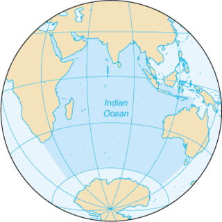
The Indian Ocean is the third-largest of the world's five oceanic divisions, covering 70,560,000 km2 (27,240,000 sq mi) or ~19.8% of the water on Earth's surface. It is bounded by Asia to the north, Africa to the west and Australia to the east. To the south it is bounded by the Southern Ocean or Antarctica depending on the definition in use. Along its core, the Indian Ocean has some large marginal or regional seas such as the Arabian Sea, Laccadive Sea, Bay of Bengal and Andaman Sea.
The Mariana Trench is an oceanic trench located in the western Pacific Ocean, about 200 kilometres (124 mi) east of the Mariana Islands; it is the deepest oceanic trench on Earth. It is crescent-shaped and measures about 2,550 km (1,580 mi) in length and 69 km (43 mi) in width. The maximum known depth is 10,984 ± 25 metres at the southern end of a small slot-shaped valley in its floor known as the Challenger Deep. The deepest point of the trench is more than 2 km (1.2 mi) farther from sea level than the peak of Mount Everest.
Hermione most commonly refers to:

The Ross Sea is a deep bay of the Southern Ocean in Antarctica, between Victoria Land and Marie Byrd Land and within the Ross Embayment, and is the southernmost sea on Earth. It derives its name from the British explorer James Clark Ross who visited this area in 1841. To the west of the sea lies Ross Island and Victoria Land, to the east Roosevelt Island and Edward VII Peninsula in Marie Byrd Land, while the southernmost part is covered by the Ross Ice Shelf, and is about 200 miles (320 km) from the South Pole. Its boundaries and area have been defined by the New Zealand National Institute of Water and Atmospheric Research as having an area of 637,000 square kilometres (246,000 sq mi).

A seamount is a large submarine landform that rises from the ocean floor without reaching the water surface, and thus is not an island, islet, or cliff-rock. Seamounts are typically formed from extinct volcanoes that rise abruptly and are usually found rising from the seafloor to 1,000–4,000 m (3,300–13,100 ft) in height. They are defined by oceanographers as independent features that rise to at least 1,000 m (3,281 ft) above the seafloor, characteristically of conical form. The peaks are often found hundreds to thousands of meters below the surface, and are therefore considered to be within the deep sea. During their evolution over geologic time, the largest seamounts may reach the sea surface where wave action erodes the summit to form a flat surface. After they have subsided and sunk below the sea surface such flat-top seamounts are called "guyots" or "tablemounts".
Hermes is the divine messenger of the Olympian gods in Greek mythology.

A conventional idea of a sustainable fishery is that it is one that is harvested at a sustainable rate, where the fish population does not decline over time because of fishing practices. Sustainability in fisheries combines theoretical disciplines, such as the population dynamics of fisheries, with practical strategies, such as avoiding overfishing through techniques such as individual fishing quotas, curtailing destructive and illegal fishing practices by lobbying for appropriate law and policy, setting up protected areas, restoring collapsed fisheries, incorporating all externalities involved in harvesting marine ecosystems into fishery economics, educating stakeholders and the wider public, and developing independent certification programs.

The benthic zone is the ecological region at the lowest level of a body of water such as an ocean, lake, or stream, including the sediment surface and some sub-surface layers. The name comes from ancient Greek, βένθος (bénthos), meaning "the depths." Organisms living in this zone are called benthos and include microorganisms as well as larger invertebrates, such as crustaceans and polychaetes. Organisms here generally live in close relationship with the substrate and many are permanently attached to the bottom. The benthic boundary layer, which includes the bottom layer of water and the uppermost layer of sediment directly influenced by the overlying water, is an integral part of the benthic zone, as it greatly influences the biological activity that takes place there. Examples of contact soil layers include sand bottoms, rocky outcrops, coral, and bay mud.

An exclusive economic zone (EEZ), as prescribed by the 1982 United Nations Convention on the Law of the Sea, is an area of the sea in which a sovereign state has special rights regarding the exploration and use of marine resources, including energy production from water and wind. It stretches from the outer limit of the territorial sea out to 200 nautical miles (nmi) from the coast of the state in question. It is also referred to as a maritime continental margin and, in colloquial usage, may include the continental shelf. The term does not include either the territorial sea or the continental shelf beyond the 200 nautical mile limit. The difference between the territorial sea and the exclusive economic zone is that the first confers full sovereignty over the waters, whereas the second is merely a "sovereign right" which refers to the coastal state's rights below the surface of the sea. The surface waters are international waters.

An abyssal plain is an underwater plain on the deep ocean floor, usually found at depths between 3,000 and 6,000 metres. Lying generally between the foot of a continental rise and a mid-ocean ridge, abyssal plains cover more than 50% of the Earth's surface. They are among the flattest, smoothest, and least explored regions on Earth. Abyssal plains are key geologic elements of oceanic basins.

Marine conservation, also known as ocean conservation, is the protection and preservation of ecosystems in oceans and seas through planned management in order to prevent the over-exploitation of these marine resources. Marine conservation is informed by the study of marine plants and animal resources and ecosystem functions and is driven by response to the manifested negative effects seen in the environment such as species loss, habitat degradation and changes in ecosystem functions and focuses on limiting human-caused damage to marine ecosystems, restoring damaged marine ecosystems, and preserving vulnerable species and ecosystems of the marine life. Marine conservation is a relatively new discipline which has developed as a response to biological issues such as extinction and marine habitats change.
The Census of Marine Life was a 10-year, US $650 million scientific initiative, involving a global network of researchers in more than 80 nations, engaged to assess and explain the diversity, distribution, and abundance of life in the oceans. The world's first comprehensive Census of Marine Life — past, present, and future — was released in 2010 in London. Initially supported by funding from the Alfred P. Sloan Foundation, the project was successful in generating many times that initial investment in additional support and substantially increased the baselines of knowledge in often underexplored ocean realms, as well as engaging over 2,700 different researchers for the first time in a global collaborative community united in a common goal, and has been described as "one of the largest scientific collaborations ever conducted".

The Arctic Ocean is the smallest and shallowest of the world's five major oceans. It spans an area of approximately 14,060,000 km2 (5,430,000 sq mi) and is known as one of the coldest of oceans. The International Hydrographic Organization (IHO) recognizes it as an ocean, although some oceanographers call it the Arctic Mediterranean Sea. It has also been described as an estuary of the Atlantic Ocean. It is also seen as the northernmost part of the all-encompassing World Ocean.

Hotspot Ecosystem Research and Man's Impact On European Seas (HERMIONE) is an international multidisciplinary project, started in April 2009, that studies deep-sea ecosystems. HERMIONE scientists study the distribution of hotspot ecosystems, how they function and how they interconnect, partially in the context of how these ecosystems are being affected by climate change and impacted by humans through overfishing, resource extraction, seabed installations and pollution. Major aims of the project are to understand how humans are affecting the deep-sea environment and to provide policy makers with accurate scientific information, enabling effective management strategies to protect deep sea ecosystems. The HERMIONE project is funded by the European Commission's Seventh Framework Programme, and is the successor to the HERMES project, which concluded in March 2009.

Antje Boetius is a German marine biologist. She is a professor of geomicrobiology at the Max Planck Institute for Marine Microbiology, University of Bremen. Boetius received the Gottfried Wilhelm Leibniz Prize in March 2009 for her study of sea bed microorganisms that affect the global climate. She is also the director of Germany's polar research hub, the Alfred Wegener Institute.
Living Oceans Society is a Canadian environmental organization that has been a leader in the effort to protect Canada's oceans since 1998. It is based in Sointula, British Columbia, with a satellite office in Vancouver, British Columbia. Living Oceans Society's vision states that: Canada's oceans are sustainably managed and thriving with abundant sea life that supports vibrant and resilient communities.

The GEOMAR - Helmholtz Centre for Ocean Research Kiel (GEOMAR), formerly known as the Leibniz Institute of Marine Sciences, is a research institute in Kiel, Germany. It was formed in 2004 by merging the Institute for Marine Science with the Research Center for Marine Geosciences (GEOMAR) and is co-funded by both federal and provincial governments. It was a member of the Leibniz Association until 2012 and is coordinator of the FishBase Consortium. Since 2012 it is member of the Helmholtz Association and named GEOMAR - Helmholtz Centre for Ocean Research Kiel. The institute operates worldwide in all ocean basins, specialising in climate dynamics, marine ecology and biogeochemistry, and ocean floor dynamics and circulation. GEOMAR offers degree courses in affiliation with the University of Kiel, and operates the Kiel Aquarium and the Lithothek, a repository for split sediment core samples.
The following outline is provided as an overview of and topical guide to fisheries:
Imants (Monty) George Priede is a British-Latvian zoologist, author and academic. He is Professor Emeritus in the University of Aberdeen, Scotland known for his work on fish and life in the deep sea.
References
- ↑ "HERMES, Hotspot Ecosystems Research on the Margins of European Seas". HERMES. Archived from the original on 2011-04-25. Retrieved 2009-12-11.
- ↑ Weaver, P.P.E., and Gunn, V. (2009). "HERMES: Hotspot Ecosystem Research on the Margins of European Seas". Archived 2011-07-23 at the Wayback Machine Oceanography 22 (1), March 2009.
- ↑ Grehan et al (2009). "HERMES: Promoting Ecosystem-Based Management and the Sustainable Use and Governance of Deep-Water Resources". Archived 2011-07-23 at the Wayback Machine Oceanography 22 (1), March 2009.
- ↑ "HERMIONE, Hotspot Ecosystem Research Resources and Information". HERMIONE. Archived from the original on 2017-09-08. Retrieved 2021-05-15.
| Main fields |  | |
|---|---|---|
| Related fields | ||
| Applications | ||
| Lists | ||
| See also | ||
 | ||
| | This oceanography article is a stub. You can help Wikipedia by expanding it. |
| | This article about climate change is a stub. You can help Wikipedia by expanding it. See guidelines for writing about climate change. Further suggestions might be found on the article's talk page. |