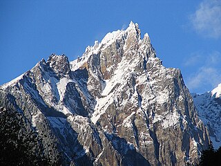
The Vulcan's Thumb is a rock pinnacle in the Pacific Ranges of southwestern British Columbia, Canada. It is the largest of a number of slender pinnacles protruding from the sharp summit ridge of Pyroclastic Peak, which forms part of the Mount Cayley massif.

Volcanic activity is a major part of the geology of Canada and is characterized by many types of volcanic landform, including lava flows, volcanic plateaus, lava domes, cinder cones, stratovolcanoes, shield volcanoes, submarine volcanoes, calderas, diatremes, and maars, along with less common volcanic forms such as tuyas and subglacial mounds.

The geology of the Pacific Northwest includes the composition, structure, physical properties and the processes that shape the Pacific Northwest region of North America. The region is part of the Ring of Fire: the subduction of the Pacific and Farallon Plates under the North American Plate is responsible for many of the area's scenic features as well as some of its hazards, such as volcanoes, earthquakes, and landslides.

The New England hotspot, also referred to as the Great Meteor hotspot and sometimes the Monteregian hotspot, is a volcanic hotspot in the North Atlantic Ocean. It created the Monteregian Hills intrusions in Montreal and Montérégie, the White Mountains intrusions in New Hampshire, the New England and Corner Rise seamounts off the coast of North America, and the Seewarte Seamounts east of the Mid-Atlantic Ridge on the African Plate, the latter of which include its most recent eruptive center, the Great Meteor Seamount. The New England, Great Meteor, or Monteregian hotspot track has been used to estimate the movement of the North American Plate away from the African Plate from the early Cretaceous period to the present using the fixed hotspot reference frame.

Bowie Seamount, or SG̱aan Ḵinghlas in the Haida language, is a large submarine volcano in the northeastern Pacific Ocean, located 180 km (110 mi) west of Haida Gwaii, British Columbia, Canada. The seamount is also known as Bowie Bank. The English name for the feature is after William Bowie of the United States Coast and Geodetic Survey.

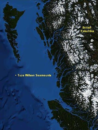
The Tuzo Wilson Seamounts, also called J. Tuzo Wilson Knolls and Tuzo Wilson Knolls, are two young active submarine volcanoes off the coast of British Columbia, Canada, located 200 km (124 mi) northwest of Vancouver Island and south of the Haida Gwaii archipelago The two seamounts are members of the Kodiak-Bowie Seamount chain, rising 500 m (1,640 ft) to 700 m (2,297 ft) above the mean level of the northeastern Pacific Ocean and is a seismically active site southwest of the southern end of the Queen Charlotte Fault. They are named after Canadian geologist John Tuzo Wilson.

Hodgkins Seamount is a seamount in the Kodiak-Bowie Seamount chain, located south of Pierce Seamount and north of Bowie Seamount. It has apparently experienced two generically different episodes of volcanism, separated by about 12 million years. Like the rest of the Kodiak-Bowie seamounts, it was formed by the Bowie hotspot.
The Explorer Seamount is a seamount located in the Pacific Ocean off the coast of British Columbia, Canada. It is on the Explorer Ridge, a tectonic spreading centre that separates the Pacific and Explorer plates and so the volcanism is rift-related. It is the namesake of the Explorer Ridge.

Peirce Seamount, also called Pierce Seamount, is a seamount located in the Pacific Ocean west of the Queen Charlotte Islands, British Columbia, Canada. It lies between Denson Seamount and Hodgkins Seamount and is member of the Kodiak-Bowie Seamount chain, a chain of seamounts in southeastern Gulf of Alaska stretching from the Aleutian Trench in the north to Bowie Seamount in the south.
The Graham Seamount is a seamount located in the Pacific Ocean off the coast of Haida Gwaii, British Columbia, Canada.
The Oshawa Seamount is a seamount located in the Pacific Ocean off the coast of Haida Gwaii, British Columbia, Canada.
The Dellwood Seamounts are a seamount range located in the Pacific Ocean northwest of Vancouver Island, British Columbia, Canada. They are also known as the Dellwood Seamount Range or the Dellwood Seamount Chain.
The Tucker Seamount is a seamount located in the Pacific Ocean off the coast of northern Vancouver Island, British Columbia, Canada.
The Chelan Seamount is a seamount located in the Pacific Ocean off the coast of northern Vancouver Island, British Columbia, Canada.
The Seminole Seamount is a seamount located in the Pacific Ocean off the coast of northern Vancouver Island, British Columbia, Canada.
The Union Seamount is a seamount located in the Pacific Ocean off the coast of northern Vancouver Island, British Columbia, Canada.
The Heck Seamount is a seamount located in the Pacific Ocean off the coast of central Vancouver Island, British Columbia, Canada.
The Triplex Cones are a group of three cinder cones in northern British Columbia, Canada. They are thought to have last erupted during the Holocene epoch.

The Newfoundland Seamounts are a group of seamounts offshore of Eastern Canada in the northern Atlantic Ocean. Named for the island of Newfoundland, this group of seamounts formed during the Cretaceous period and are poorly studied.

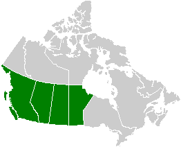
Volcanism of Western Canada has produced lava flows, lava plateaus, lava domes, cinder cones, stratovolcanoes, shield volcanoes, greenstone belts, submarine volcanoes, calderas, diatremes and maars, along with examples of more less common volcanic forms such as tuyas and subglacial mounds.


