Related Research Articles

Plate tectonics is the generally accepted scientific theory that considers the Earth's lithosphere to comprise a number of large tectonic plates which have been slowly moving since about 3.4 billion years ago. The model builds on the concept of continental drift, an idea developed during the first decades of the 20th century. Plate tectonics came to be generally accepted by geoscientists after seafloor spreading was validated in the mid to late 1960s.

Oceanic trenches are prominent, long, narrow topographic depressions of the ocean floor. They are typically 50 to 100 kilometers wide and 3 to 4 km below the level of the surrounding oceanic floor, but can be thousands of kilometers in length. There are about 50,000 km (31,000 mi) of oceanic trenches worldwide, mostly around the Pacific Ocean, but also in the eastern Indian Ocean and a few other locations. The greatest ocean depth measured is in the Challenger Deep of the Mariana Trench, at a depth of 10,920 m (35,830 ft) below sea level.
Subduction is a geological process in which the oceanic lithosphere and some continental lithosphere is recycled into the Earth's mantle at convergent boundaries. Where the oceanic lithosphere of a tectonic plate converges with the less dense lithosphere of a second plate, the heavier plate dives beneath the second plate and sinks into the mantle. A region where this process occurs is known as a subduction zone, and its surface expression is known as an arc-trench complex. The process of subduction has created most of the Earth's continental crust. Rates of subduction are typically measured in centimeters per year, with rates of convergence as high as 11 cm/year.

In marine geology, a guyot, also called a tablemount, is an isolated underwater volcanic mountain (seamount) with a flat top more than 200 m (660 ft) below the surface of the sea. The diameters of these flat summits can exceed 10 km (6.2 mi). Guyots are most commonly found in the Pacific Ocean, but they have been identified in all the oceans except the Arctic Ocean. They are analogous to tables on land.

A seamount is a large submarine landform that rises from the ocean floor without reaching the water surface, and thus is not an island, islet, or cliff-rock. Seamounts are typically formed from extinct volcanoes that rise abruptly and are usually found rising from the seafloor to 1,000–4,000 m (3,300–13,100 ft) in height. They are defined by oceanographers as independent features that rise to at least 1,000 m (3,281 ft) above the seafloor, characteristically of conical form. The peaks are often found hundreds to thousands of meters below the surface, and are therefore considered to be within the deep sea. During their evolution over geologic time, the largest seamounts may reach the sea surface where wave action erodes the summit to form a flat surface. After they have subsided and sunk below the sea surface such flat-top seamounts are called "guyots" or "tablemounts".
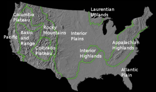
The richly textured landscape of the United States is a product of the dueling forces of plate tectonics, weathering and erosion. Over the 4.5 billion-year history of the Earth, tectonic upheavals and colliding plates have raised great mountain ranges while the forces of erosion and weathering worked to tear them down. Even after many millions of years, records of Earth's great upheavals remain imprinted as textural variations and surface patterns that define distinctive landscapes or provinces.

An abyssal plain is an underwater plain on the deep ocean floor, usually found at depths between 3,000 and 6,000 m. Lying generally between the foot of a continental rise and a mid-ocean ridge, abyssal plains cover more than 50% of the Earth's surface. They are among the flattest, smoothest, and least explored regions on Earth. Abyssal plains are key geologic elements of oceanic basins.
Oceanic crust is the uppermost layer of the oceanic portion of the tectonic plates. It is composed of the upper oceanic crust, with pillow lavas and a dike complex, and the lower oceanic crust, composed of troctolite, gabbro and ultramafic cumulates. The crust overlies the rigid uppermost layer of the mantle. The crust and the rigid upper mantle layer together constitute oceanic lithosphere.
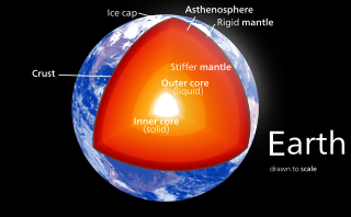
Earth's mantle is a layer of silicate rock between the crust and the outer core. It has a mass of 4.01 × 1024 kg and thus makes up 67% of the mass of Earth. It has a thickness of 2,900 kilometers (1,800 mi) making up about 84% of Earth's volume. It is predominantly solid but, on geologic time scales, it behaves as a viscous fluid, sometimes described as having the consistency of caramel. Partial melting of the mantle at mid-ocean ridges produces oceanic crust, and partial melting of the mantle at subduction zones produces continental crust.

The seabed is the bottom of the ocean. All floors of the ocean are known as 'seabeds'.
In hydrology, an oceanic basin (or ocean basin) is anywhere on Earth that is covered by seawater. Geologically, most of the ocean basins are large geologic basins that are below sea level.

Marine geology or geological oceanography is the study of the history and structure of the ocean floor. It involves geophysical, geochemical, sedimentological and paleontological investigations of the ocean floor and coastal zone. Marine geology has strong ties to geophysics and to physical oceanography.

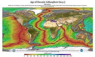
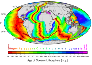
A mid-ocean ridge (MOR) is a seafloor mountain system formed by plate tectonics. It typically has a depth of about 2,600 meters (8,500 ft) and rises about 2,000 meters (6,600 ft) above the deepest portion of an ocean basin. This feature is where seafloor spreading takes place along a divergent plate boundary. The rate of seafloor spreading determines the morphology of the crest of the mid-ocean ridge and its width in an ocean basin.
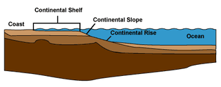
A continental margin is the outer edge of continental crust abutting oceanic crust under coastal waters. It is one of the three major zones of the ocean floor, the other two being deep-ocean basins and mid-ocean ridges. The continental margin consists of three different features: the continental rise, the continental slope, and the continental shelf. The continental shelf is the relatively shallow water area found in proximity to continents. Continental margins constitute about 28% of the oceanic area.

The Bounty Trough is a major submerged feature, a bathymetric depression, of the oceanography of the southwest Pacific Ocean. It is located off the east coast of New Zealand's South Island. It is named after the Bounty Islands near the Eastern end of the trough. The islands, in turn, are named after HMS Bounty.

Kenneth Craig Macdonald is an American oceanographer and marine geophysicist born in San Francisco, California in 1947. As of 2018 he is professor emeritus at the Department of Earth Science and the Marine Sciences Institute at the University of California, Santa Barbara (UCSB). His work focuses on the tectonics and geophysics of the global mid-oceanic ridge including its spreading centers and transform faults, two of the three types of plate boundaries central to the theory of plate tectonics. His work has taken him to the north and south Atlantic oceans, the north and south Pacific oceans, the Indian Ocean, the Red Sea and the Sea of Cortez, as well as to the deep seafloor on over 50 dives in the research submersible ALVIN. Macdonald has participated in over 40 deep sea expeditions, and was chief- or co-chief scientist on 31 expeditions.

The Aleutian subduction zone is a 2,500 mi (4,000 km) long convergent boundary between the North American Plate and the Pacific Plate, that extends from the Alaska Range to the Kamchatka Peninsula. Here, the Pacific Plate is being subducted underneath the North American Plate and the rate of subduction changes from west to east from 7.5 to 5.1 cm per year. The Aleutian subduction zone includes two prominent features, the Aleutian Arc and the Aleutian Trench. The Aleutian Arc was created via volcanic eruptions from dehydration of the subducting slab at ~100 km depth. The Aleutian Trench is a narrow and deep morphology that occurs between the two converging plates as the subducting slab dives beneath the overriding plate.
Madeira Abyssal Plain, also called Madeira Plain, is an abyssal plain situated at the center and deepest part of the Canary Basin. It is a north-northeast to south-southeast elongated basin that almost parallels the Mid-Atlantic Ridge. Its western boundary is marked by a chain of seamounts known as the either Seewarte Seamounts or Atlantis-Great Meteor Seamount Chain. Its eastern boundary is a distinct break of slope that marks the foot of the African Continental Rise. This abyssal plain occupies an area of about 68,000 km2 (26,000 sq mi). Across this basin, slope angles are generally less than 0.01°.
Marine geophysics is the scientific discipline that employs methods of geophysics to study the world's ocean basins and continental margins, particularly the solid earth beneath the ocean. It shares objectives with marine geology, which uses sedimentological, paleontological, and geochemical methods. Marine geophysical data analyses led to the theories of seafloor spreading and plate tectonics.
References
- 1 2 3 Kennish, Michael J. (2001). Practical handbook of marine science. Marine science series (3rd ed.). CRC Press. p. 282. ISBN 0-8493-2391-6.
- ↑ Heezen, Bruce C.; Laughton, A. S. (1963). "Abyssal Plains". In M. N. Hill (ed.). Earth Beneath Sea History Sea. Sea: Ideas and Observations on Progress in the Study of the Seas. Vol. 3. Harvard University Press. p. 312. ISBN 0-674-01730-7.
- ↑ Dilek, Y. (1998). "Structure and tectonics of intermediate-spread oceanic crust drilled at DSDP/ODP Holes 504B and 896A, Costa Rica Rift". In Adrian Cramp (ed.). Geological evolution of ocean basins: results from the Ocean Drilling Program. Geological Society special publication. Vol. 131. Geological Society. p. 194. ISBN 1-86239-003-7.