Solomon Archipelago

Last updated
Solomon Archipelago
Solomon Isles.jpg
Aerial view of islands in Solomon Archipelago
Political map of the Solomon Islands archipelago in 1989.jpg
The Solomon Islands archipelago
Geography
Location Pacific Ocean
Coordinates 9°28′S159°49′E / 9.467°S 159.817°E / -9.467; 159.817
Archipelago Solomon Islands archipelago
Total islands6 main islands and more than 986 smaller islands
Major islands Bougainville, Choiseul, the New Georgia Islands, Santa Isabel, Malaita, Makira (San Cristobal), Guadalcanal.
Administration

The Solomon Archipelago is a terrestrial ecoregion and marine ecoregion in the Pacific Ocean. It includes the tropical ocean waters surrounding most of the Solomon Islands archipelago (excluding the Santa Cruz Islands, which is a part of the Vanuatu marine ecoregion with the forests being part of the Vanuatu rain forests ecoregion), and includes Bougainville Island and Buka Island of Papua New Guinea and their surrounding waters.

Contents

Bougainville is the largest island in the archipelago, while it is geographically part of the Solomon Archipelago, it is politically an autonomous region of Papua New Guinea.

The Solomon Islands rain forests form part of the East Melanesian Islands ecoregion, also known as the Solomons-Vanuatu-Bismarck moist forests, which is a biogeographic region in the Melanesia subregion of Oceania. [1]

Key Biodiversity Areas

In the Solomon Islands there are 28 land based and 24 marine protected areas formally recognised (PIPAP 2016). [2] The Pacific Islands Protected Areas Portal (PIPAP 2021) states that 530.42 km2 (204.80 sq mi) out of 29,191.65 km2 (11,270.96 sq mi) (1.82%) of the total land area of Solomon Islands is protected, while 1,879.38 km2 (725.63 sq mi) out of 1,609,756.55 km2 (621,530.48 sq mi) (0.12%) of the total marine area is protected. [3]

The protected areas in the Solomon Archipelago include: Arnavon Community Marine Conservation Area, Kolombangara Forest Reserve, Makira Highlands Conservation Area and Komarindi Catchment Conservation Area on Guadalcanal. [4] There are 36 Key Biodiversity Areas identified for the Solomon archipelago, including Kunua Plains and Mount Balbi on Bougainville Island, Mount Maetambe – Kolombangara River Important Bird Area on Choiseul Island, Kolombangara Upland Forest, Guadalcanal Watersheds, Nendö Island and Marovo Kavachi, a submarine volcano known as Kavachi, which is 28 km (20 mi) to the south of Vangunu. [4] [5]

Tropical forests of the Solomon Archipelago

Kirakira River and Beach, Makira Kirakira River and Beach.JPG
Kirakira River and Beach, Makira

This ecoregion consists of tropical lowland and montane forests on oceanic islands. The islands are predominantly hill forest, although only a few of the islands are higher than 1,000 metres (3,281 ft) in elevation. The vegetation types in this ecoregion, include mangrove forests and saline swamp forests, coastal strand vegetation, freshwater swamp, riverine forests, different types of lowland rain forests and montane rain forest. [6] [2] The Solomon Islanders use trees from different forest types for housing, food and medicinal purposes. [7] Large areas of the natural forest below 400 metres (1,312 ft) have been logged or are planned to be logged. Forest clearing for subsistence agriculture also reduces the amount of natural forest. [5]

Seasonally dry forest and grassland is found only on the leeward (north) side of Guadalcanal as the result of the “rain shadow” caused by the mountains of Guadalcanal which are higher than 2,000 metres (6,562 ft) in elevation. [6]

Coral Triangle

A dugong mother and calf in shallow water Dugong.jpg
A dugong mother and calf in shallow water

Fringing reefs are located around the coast of the mountainous high islands of the Solomon Archipelago including: Choiseul, the Shortland Islands, the New Georgia Islands, Santa Isabel, the Russell Islands, the Florida Islands, Tulagi, Malaita, Maramasike, Ulawa, Owaraha (Santa Ana), Makira (San Cristobal), and the main island of Guadalcanal.

According to the WWF/Nature Conservancy system, the Solomon Archipelago is part of the Eastern Coral Triangle marine province of the Central Indo-Pacific marine realm. [8]

The Solomon archipelago has a rich and diverse marine life, including coral reefs and seagrass meadows. The archipelago is part of the Coral Triangle, the region of the western Pacific with world's greatest diversity of corals and coral reef species. The baseline survey of marine biodiversity in 2004, [9] identified 494 coral species, including nine potentially new species and extended the known range of 122 coral species to include the Solomons. [10] The 2004 survey also recorded 1,019 species of reef fish, of which 47 were species range extensions. [11]

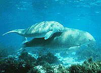
Dugongs are found in the seagrass meadows and near-shore waters. [12]

Reptiles

Solomon Islands skink Corucia zebrata.jpg
Solomon Islands skink

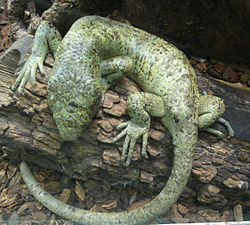
Lizards are the most diverse group of reptiles in the Solomon Archipelago, and within the lizards there are several different types: skinks (including the Solomon Islands skink or prehensile tailed skink Corucia zebrata and Poncelet’s crocodile skink Tribolonotus ponceleti , which are endemic to the Solomon archipelago), geckos, varanids (or ‘monitors’), and agamids (or ‘dragons’) of the genus Hydrosaurus . [6]

Different snake species are found in the Solomon Archipelago, ranging from those that live in the ocean (sea kraits and sea snakes), those that live in moist conditions underground or in rotting logs and leaf litter (blind snakes Acutotyphlops ), and those that are found in the trees (South Pacific tree boa, the brown tree snake Boiga irregularis and the Solomons tree snake Dendrelaphis calligastra ). The sea kraits, and two other terrestrial species, the Solomons Red Krait Salomonelaps par and the Solomons Black-banded krait Loveridgelaps elapoides , are members of the cobra family ( Elapidae ) and are considered dangerous due to their toxic venom. [6]

One species of crocodile, the saltwater crocodile (Crocodylus porosus) is found in mangrove swamps, rivers and tidal estuaries, and also in the open ocean. [6]

The mammalian species of the Solomon archipelago

Bougainville monkey-faced bat Pteralopex anceps.jpg
Bougainville monkey-faced bat

Although this oceanic island ecoregion contains only forty-seven mammal species, twenty-six of those species are endemic or near endemic, including nine murid rodents (Melomys, Solomys, Uromys), fifteen pteropodid bats (Dobsonia, Melonycteris, Nyctimene, Pteralopex, Pteropus), one molossid bat ( Chaerephon ) and the Flower-faced bat (Anthops ornatus). Three of the fruit bats, Bougainville monkey-faced bat (Pteralopex anceps), Guadalcanal monkey-faced bat (Pteralopex atrata) and Montane monkey-faced bat (Pteralopex pulchra), are critically endangered, and three of the rodents are endangered, Buka Island mosaic-tailed rat or Buka Island melomys (Melomys spechti), Poncelet's giant rat or Poncelet's naked-tailed rat (Solomys ponceleti), and emperor rat (Uromys imperator) that is endemic to Guadalcanal. [5]

The bird species of the Solomon archipelago

Ducorps' cockatoo Hana2.jpg
Ducorps' cockatoo

This oceanic island ecoregion has least seven endemic genera of birds. Makira (San Cristobal) and the New Georgia group, have their own endemic species. [5] A total of 199 bird species inhabit the Solomons and of those birds, about 69 bird species are found nowhere else in the world. Two bird species are critically endangered: Makira woodhen (Gallinula silvestris), yellow-legged pigeon (Columba pallidiceps). Four bird species are endangered: imitator goshawk or imitator sparrowhawk (Accipiter imitator), Woodford's rail (Hypotaenidia woodfordi), red-knobbed imperial pigeon (Ducula rubricera), and white-eyed starling (Aplonis brunneicapillus). [5]

Related Research Articles

<span class="mw-page-title-main">Geography of the Solomon Islands</span>

Solomon Islands is an island country in the South Pacific Ocean, that lies east of Papua New Guinea.

<span class="mw-page-title-main">Solomon Islands</span> Country in the southwestern Pacific

Solomon Islands, also known simply as the Solomons, is a country consisting of six major islands and over 900 smaller islands in Melanesia, part of Oceania, to the northeast of Australia. It is directly adjacent to Papua New Guinea to the northwest, Australia to the southwest, New Caledonia and Vanuatu to the southeast, Fiji, Wallis and Futuna, and Tuvalu to the east, and Nauru and the Federated States of Micronesia to the north. It has a total area of 28,896 square kilometres, and a population of 734,887 according to the official estimates for mid 2023. Its capital, Honiara, is located on the largest island, Guadalcanal. The country takes its name from the wider area of the Solomon Islands archipelago, which is a collection of Melanesian islands that also includes the Autonomous Region of Bougainville, but excludes the Santa Cruz Islands.

<span class="mw-page-title-main">Solomon Islands rain forests</span>

The Solomon Islands rain forests are a terrestrial ecoregion covering the Solomon Islands archipelago.

<span class="mw-page-title-main">Makira</span> An island in Solomon Islands

The island of Makira is the largest island of Makira-Ulawa Province in Solomon Islands. It is third most populous of the Solomon Islands after Malaita and Guadalcanal, with a population of 55,126 as of 2020. The island is located east of Guadalcanal and south of Malaita. The largest and capital city is Kirakira.

<span class="mw-page-title-main">Malaita</span> Primary island of Malaita Province in Solomon Islands

Malaita is the primary island of Malaita Province in Solomon Islands. Malaita is the most populous island of the Solomon Islands, with a population of 161,832 as of 2021, or more than a third of the entire national population. It is also the second largest island in the country by area, after Guadalcanal.

<span class="mw-page-title-main">Crested cuckoo-dove</span> Species of bird

The crested cuckoo-dove is a species of bird in the pigeon family, Columbidae. First described by English zoologist John Gould in 1856, it is endemic to the Solomon Islands archipelago, where it mainly inhabits hill forests at elevations of 500–900 m (1,600–3,000 ft). It is a large and robust pigeon, with a length of 40–42 cm (16–17 in) and a distinctive pale purplish-grey crest. Adults are mainly bluish-grey, with a pale greyish-buff throat, blackish tail, and yellow-tipped reddish bill. Both sexes look alike. Juveniles lack the crest, have darker heads, and have duller wings.

<span class="mw-page-title-main">Barred cuckooshrike</span> Species of bird

The barred cuckooshrike, also called the yellow-eyed cuckooshrike, is a species of bird in the family Campephagidae. It is found in eastern Australia, Indonesia, Papua New Guinea, and Solomon Islands.

<span class="mw-page-title-main">Grey-throated white-eye</span> Species of bird

The grey-throated white-eye is a species of bird. Its family, the Zosteropidae, is probably not valid and belongs in the Timaliidae instead. It is also known as Zosterops ugiensis because Z. rendovae has often been used for the Solomons white-eye.

<span class="mw-page-title-main">Bougainville monkey-faced bat</span> Species of mammal

The Bougainville monkey-faced bat or Bougainville flying monkey is a megabat endemic to Bougainville Island of Papua New Guinea and Choiseul Island of the Solomon Islands in Melanesia. It inhabits mature forests in upland areas, within the Autonomous Region of Bougainville and Bougouriba Province.

<span class="mw-page-title-main">Guadalcanal monkey-faced bat</span> Species of mammal

The Guadalcanal monkey-faced bat or Guadalcanal flying monkey is a megabat endemic to Solomon Islands. It is listed as an endangered species. In 2013, Bat Conservation International listed this species as one of the 35 species of its worldwide priority list of conservation.

<span class="mw-page-title-main">Outline of Solomon Islands</span> Overview of and topical guide to Solomon Islands

The following outline is provided as an overview of and topical guide to Solomon Islands:

<i>Pteralopex</i> Genus of bats

Pteralopex is a genus of large megabats in the family Pteropodidae. Species in this genus are commonly known as "monkey-faced bats". They are restricted to Solomon Islands rain forests in Melanesia, and all species are seriously threatened, being rated as either endangered or critically endangered by IUCN. Two species, P. taki and P. flanneryi, have been described since 2000.

<span class="mw-page-title-main">Central Indo-Pacific</span> Biogeographic sea region

The Central Indo-Pacific is a biogeographic region of Earth's seas, comprising the tropical waters of the western Pacific Ocean, the eastern Indian Ocean, and the connecting seas.

<span class="mw-page-title-main">Solomon Islands (archipelago)</span> Archipelago in the South Pacific spreading over two countries

The Solomon Islands (archipelago) is an island group in the western South Pacific Ocean, north-east of Australia. The archipelago is in the Melanesian subregion and bioregion of Oceania and forms the eastern boundary of the Solomon Sea. The many islands of the archipelago are distributed across Papua New Guinea and Solomon Islands (country). The largest island in the archipelago is Bougainville Island, which is a part of the Autonomous Region of Bougainville along with Buka Island, the Nukumanu Islands, and a number of smaller nearby islands. Much of the remainder falls within the territory of Solomon Islands and include the atolls of Ontong Java, Sikaiana, the raised coral atolls of Bellona and Rennell, and the volcanic islands of Choiseul, Guadalcanal, Makira, Malaita, New Georgia, the Nggelas, Santa Isabel, and the Shortlands. The Santa Cruz Islands are not a part of the archipelago.

<span class="mw-page-title-main">Greater monkey-faced bat</span> Species of mammal

The greater monkey-faced bat or greater flying monkey is a megabat endemic to Solomon Islands, Bougainville, in Papua New Guinea, and nearby small islands. It is listed as a critically endangered species and the population is decreasing. It is the largest monkey-faced bat.

The Funafuti Conservation Area is a marine conservation area covering 33 square kilometers of reef, lagoon and motu (islets) on the western side of Funafuti atoll in Tuvalu. The marine environment of the conservation area includes reef, lagoon, channel and ocean; and are home to many species of fish, corals, algae and invertebrates. The islets are nesting sites for the green sea turtle and Fualopa hosts a breeding colony of black noddy.

<span class="mw-page-title-main">Kilu Cave</span> Anthropological site in Papua New Guinea

Kilu Cave is a paleoanthropological site located on Buka Island in the Autonomous Region of Bougainville, Papua New Guinea. Kilu Cave is located at the base of a limestone cliff, 65 m (213 ft) from the modern coastline. With evidence for human occupation dating back to 30,000 years, Kilu Cave is the earliest known site for human occupation in the Solomon Islands archipelago. The site is the oldest proof of paleolithic people navigating the open ocean i.e. navigating without land in sight. To travel from Nissan island to Buka requires crossing of at least 60 kilometers of open sea. The presence of paleolithic people at Buka therefore is at the same time evidence for the oldest and the longest paleolithic sea travel known so far.

<span class="mw-page-title-main">Coral reefs of the Solomon Islands</span>

The Coral reefs of the Solomon Islands consists of six major islands and over 986 smaller islands, in Oceania, to the east of Papua New Guinea and northwest of Vanuatu. The Solomon Islands lie between latitudes 5° and 13°S, and longitudes 155° and 169°E. The distance between the westernmost and easternmost islands is about 1,500 km (930 mi). The Santa Cruz Islands are situated north of Vanuatu and are especially isolated at more than 200 km (120 mi) from the other islands. The Solomon Islands has the 22nd largest Exclusive Economic Zone of 1,589,477 km2 (613,701 sq mi) of the Pacific Ocean.

References

  1. Dinerstein, Eric; et al. (2017). "An Ecoregion-Based Approach to Protecting Half the Terrestrial Realm". BioScience. 67 (6): 534–545. doi:10.1093/biosci/bix014. ISSN   0006-3568. PMC   5451287 . PMID   28608869.
  2. 1 2 Beth Toki, Lyn Leger, Suanne Richards, Sophie Hipkin, Joseph Lorimer, Rod Coulton (2018). Solomon Islands Ecosystem and Socio-Economic Resilience Analysis and Mapping (ESRAM), Volume 1: Introduction and national assessment (PDF) (Report). Apia, Samoa: Secretariat of the Pacific Regional Environment Programme (SPREP). Retrieved 31 March 2021.{{cite report}}: CS1 maint: multiple names: authors list (link)
  3. "Solomon Islands Protection Coverage". Secretariat of the Pacific Regional Environment Programme (SPREP). 2021. Retrieved 17 April 2021.
  4. 1 2 Ceccarelli DM, Wini-Simeon, Sullivan, Wendt, Vave-Karamui, Masu, Nicolay-Grosse Hokamp, Davey, Fernandes (2018). Biophysically Special, Unique Marine Areas of the Solomon Islands (PDF) (Report). MACBIO, (GIZ, IUCN, SPREP), Suva. ISBN   978-0-9975451-6-6 . Retrieved 31 March 2021.{{cite report}}: CS1 maint: multiple names: authors list (link)
  5. 1 2 3 4 5 "Solomon Islands, east of New Guinea". World Wildlife Fund. 2020. Retrieved 17 April 2021.
  6. 1 2 3 4 5 Lavery TH, Pikacha PG, Fisher DO. (2013). Solomon Islands forest life: information on biology and management of forest resources (Report). The University of Queensland, Brisbane. ISBN   978-1-74272-157-6 . Retrieved 31 March 2021.{{cite report}}: CS1 maint: multiple names: authors list (link)
  7. Takuro Furusawa, Myknee Qusa Sirikolo, Masatoshi Sasaoka, and Ryutaro Ohtsuka (2014). "Interaction between forest biodiversity and people's use of forest resources in Roviana, Solomon Islands: implications for biocultural conservation under socioeconomic changes". Journal of Ethnobiology and Ethnomedicine. 10: 10. doi: 10.1186/1746-4269-10-10 . PMC   3974228 . PMID   24468329.{{cite journal}}: CS1 maint: multiple names: authors list (link)
  8. Spalding, Mark D., Helen E. Fox, Gerald R. Allen, Nick Davidson et al. "Marine Ecoregions of the World: A Bioregionalization of Coastal and Shelf Areas". Bioscience Vol. 57 No. 7, July/August 2007, pp. 573-583.
  9. Turak, E. edited by Green, A., P. Lokani, W. Atu, P. Ramohia, P. Thomas and J. Almany (2006). Solomon Islands Marine Assessment: Technical report of survey conducted May 13 to June 17, 2004. TNC Pacific Island Countries Report No. 1/06 (PDF) (Report). DC: World Resources Institute. pp. 64–109. Retrieved 31 March 2021.{{cite report}}: |author= has generic name (help)CS1 maint: multiple names: authors list (link)
  10. Veron, J. E. N., and E. Turak, edited by Green, A., P. Lokani, W. Atu, P. Ramohia, P. Thomas and J. Almany (2006). Solomon Islands Marine Assessment: Technical report of survey conducted May 13 to June 17, 2004. TNC Pacific Island Countries Report No. 1/06 (Report). DC: World Resources Institute. pp. 35–63.{{cite report}}: |author= has generic name (help)CS1 maint: multiple names: authors list (link)
  11. Allen, G. R., edited by Green, A., P. Lokani, W. Atu, P. Ramohia, P. Thomas and J. Almany (2006). Solomon Islands Marine Assessment: Technical report of survey conducted May 13 to June 17, 2004. TNC Pacific Island Countries Report No. 1/06 (Report). DC: World Resources Institute. pp. 196–267.{{cite report}}: |author= has generic name (help)CS1 maint: multiple names: authors list (link)
  12. Green, A., P. Lokani, W. Atu, P. Ramohia, P. Thomas and J. Almany (eds.) 2006. Solomon Islands Marine Assessment: Technical report of survey conducted May 13 to June 17, 2004. TNC Pacific Island Countries Report No. 1/06.