Solomon Islands is an island country in the South Pacific Ocean, that lies east of Papua New Guinea.
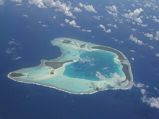
An atoll is a ring-shaped island, including a coral rim that encircles a lagoon. There may be coral islands or cays on the rim. Atolls are located in warm tropical or subtropical parts of the oceans and seas where corals can develop. Most of the approximately 440 atolls in the world are in the Pacific Ocean.

A lagoon is a shallow body of water separated from a larger body of water by a narrow landform, such as reefs, barrier islands, barrier peninsulas, or isthmuses. Lagoons are commonly divided into coastal lagoons and atoll lagoons. They have also been identified as occurring on mixed-sand and gravel coastlines. There is an overlap between bodies of water classified as coastal lagoons and bodies of water classified as estuaries. Lagoons are common coastal features around many parts of the world.

The New Georgia Islands are part of the Western Province of Solomon Islands. They are located to the northwest of Guadalcanal. The larger islands are mountainous and covered in rain forest. The main islands are New Georgia, Vella Lavella, Kolombangara, Ghizo, Vangunu, Rendova and Tetepare. They are surrounded by coral reefs and include the Marovo Lagoon.

Rennell Island, locally known as Mugaba, is the main island of two inhabited islands that make up the Rennell and Bellona Province in the nation state of Solomon Islands. Rennell Island has a land area of 660 square kilometres (250 sq mi) that is about 80 kilometres (50 mi) long and 14 kilometres (8.7 mi) wide. It is the second largest raised coral atoll in the world with the largest lake in the insular Pacific, Lake Tegano, a lake that is listed as a World Heritage Site. Rennell Island has a population of about 1,840 persons of Polynesian descent who primarily speak Rennellese, Pijin and some English. Rennell and Bellona Islands are two of the few islands in the otherwise Melanesian Solomon Islands archipelago classified as a Polynesian outlier; others being Sikaiana, Ontong Java, Tikopia, Anuta, Duff Islands, and some Reef Islands.

East Rennell is the southern portion of Rennell Island in the Solomon Islands which is designated a UNESCO World Heritage Site. Rennell is the largest raised coral atoll in the world and the area in East Rennell surrounding Lake Tegano contains many endemic species.

Vangunu is an island, part of the New Georgia Islands in Western Province, in the independent nation of Solomon Islands. It is located between New Georgia and Nggatokae Island. To the north and east of the island is Marovo Lagoon. The island has an area of 509 square kilometres (197 sq mi).

Marovo Lagoon is the largest saltwater lagoon in the world. Located in the New Georgia Islands, surrounded by Vangunu Island and Nggatokae Island, both extinct volcanic islands, at 8.48°S 158.07°E. It is part of the Solomon Islands. It encompasses 700 km2 (270 sq mi) and is protected by a double barrier reef system. Marovo Lagoon is identified as an area with high biodiversity and conservation values.

The Solomon Archipelago is a terrestrial ecoregion and marine ecoregion in the Pacific Ocean. It includes the tropical ocean waters surrounding most of the Solomon Islands archipelago, and includes Bougainville Island and Buka Island of Papua New Guinea and their surrounding waters.

Apo Reef is a coral reef system in the Philippines situated in the western waters of Occidental Mindoro province in the Mindoro Strait. Encompassing 34 square kilometres (13 sq mi), it is considered the world's second-largest contiguous coral reef system, and is the largest in the country. The reef and its surrounding waters are protected areas administered as the Apo Reef Natural Park (ARNP). It is one of the best known and most popular diving regions in the country, and is in the tentative list for UNESCO World Heritage Sites.
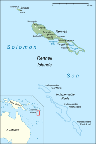
The Indispensable Reefs are a chain of three large coral atolls in the Coral Sea. They are located about 50 km (30 mi) south of Rennell Island. The chain stretches over a length of 114 km (71 mi) and its average width is 18 km (11 mi).
Arnarvon Islands are a group of islands in Solomon Islands. They are located in Isabel Province and nearby to Wagina Island in Choiseul Province.
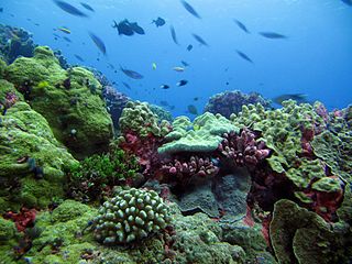
The Phoenix Islands Protected Area (PIPA) is located in the Republic of Kiribati, an ocean nation in the central Pacific approximately midway between Australia and Hawaii. PIPA constitutes 11.34% of Kiribati's exclusive economic zone (EEZ), and with a size of 408,250 km2 (157,630 sq mi), it is one of the largest marine protected areas (MPA) and one of the largest protected areas of any type on Earth. The PIPA was also designated as the world's largest and deepest UNESCO World Heritage Site in 2010.

Lighthouse Reef is an atoll in the Caribbean Sea, the easternmost part of the Belize Barrier Reef and one of its three atolls, the other two being Turneffe Atoll and Glover's Reef. Lighthouse Reef is located about 80 kilometres (50 mi) southeast of Belize City. The atoll is of oblong shape, approximately 35 kilometres (22 mi) long from north to south, and about 8 kilometres (5.0 mi) wide. It forms a shallow sandy lagoon with an area of 120 square kilometres (46 sq mi) and a depth between 2 and 6 metres deep.

The Coral reefs of Kiribati consists of 32 atolls and one raised coral island, Banaba, which is an isolated island between Nauru and the Gilbert Islands. The islands of Kiribati are dispersed over 3.5 million km2 (1.4 million sq mi) of the Pacific Ocean and straddle the equator and the 180th meridian, extending into the eastern and western hemispheres, as well as the northern and southern hemispheres. 21 of the 33 islands are inhabited. The groups of islands of Kiribati are:

The Coral reefs of the Solomon Islands consists of six major islands and over 986 smaller islands, in Oceania, to the east of Papua New Guinea and northwest of Vanuatu. The Solomon Islands lie between latitudes 5° and 13°S, and longitudes 155° and 169°E. The distance between the westernmost and easternmost islands is about 1,500 km (930 mi). The Santa Cruz Islands are situated north of Vanuatu and are especially isolated at more than 200 km (120 mi) from the other islands. The Solomon Islands has the 22nd largest Exclusive Economic Zone of 1,589,477 km2 (613,701 sq mi) of the Pacific Ocean.
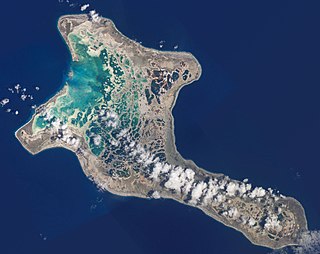
Protected areas of Kiribati include marine protected areas managed by the Environment and Conservation Division, of the Kiribati Ministry of Environment, Lands and Agricultural Development. Kiribati, in partnership with the New England Aquarium and Conservation International (CI), manages the Phoenix Islands Protected Area (PIPA), which is a World Heritage Site that was established in 2006, and is the second largest of the world's marine protected areas. The U.S. administered Pacific Remote Islands Marine National Monument is currently the world's largest designated marine protected area (MPA), and is to the north and north-east of the PIPA.

Protected areas of Tuvalu consist of protected areas located within the central Pacific country of Tuvalu and its territorial waters. One such area is the Funafuti Conservation Area, which is a marine protected area on the western reef area of Funafuti atoll.

