The state of Johor in Malaysia is noted for its national parks and forest reserves which preserve virgin rainforests known for its biodiversity and endangered species of animals. Mangrove swamps and coral reefs are also protected within these parks.
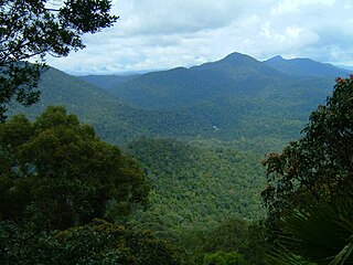
Endau Rompin National Park is located on the Johor-Pahang border (2°26′20″N103°16′22″E / 2.438915°N 103.272858°E / 2.438915; 103.272858 (Endau Rompin National Park)). The park takes its name from the Endau and Rompin rivers that flow through the park. It is the second largest national park in Peninsular Malaysia after Taman Negara, covering 489km2 with approximately 26km of jungle trails within the park. The most famous trail is a 16km trail that starts at Kuala Jasin and ends at Batu Hampar. Other sites of interest in the park are Opeh Guling waterfall, Buaya Sangkut waterfall and salt licks around Gunung Tiong. There are two entry points to the park with one at Kampung Peta and the other at Nitar. There are two other rivers, Selai and Jasin rivers, that flows through the park.
Gunung Ledang National Park
Gunung Ledang National Park is situated 170km from Johor Bahru and has an area of 107km2 (2°20′29″N102°34′26″E / 2.341496°N 102.573853°E / 2.341496; 102.573853 (Gunung Ledang National Park)). The park has two entry points, one in Sagil, Johor and the other in Asahan, Melaka. Gunung Ledang's peak, which is 1276 m above sea level is the highest point in the park and Johor. Gunung Ledang is also the 64th highest mountain in Malaysia and arguably the most climbed mountain in the country. Sagil waterfall, which is also in the park is a famous picnic site.
Gunung Belumut (Moss Mountain) Recreational Forest
Gunung Belumut (Moss Mountain) Recreational Forest (2°01′47″N103°32′23″E / 2.029643°N 103.539619°E / 2.029643; 103.539619 (Gunung Belmut Recreational Forest)) is based around the mountain, from which it gets its name. It is situated 32km from Kluang. Gunung Belumut (1010m) has a 6km path to the mountain's peak, which takes approximately four hours to reach. The park also has a unique rock formation, called Crown Rock (Batu Mahkota), which looks like a giant crown.
Sungai Sedili Besar and Sungai Sedili Kecil Wetland Preservation
It is another wetland area for the protection of migratory birds. This freshwater mangrove swamp has an area of 1.5km2.
Sungai Lebam Wetland Preservation
Sungai Lebam is a vast mangrove swamp where clams and fireflies are conserved. Fireflies congregate at the Berembang trees in the swamp. This wetland is near Kota Tinggi and approximately 91km from Johor Bahru.
Related Research Articles
Tioman Island is a mukim and an island in Rompin District, Pahang, Malaysia. It is located 32 kilometres off the east coast of the state, and is some 39 kilometres long and 12 kilometres wide. It has seven villages, the largest and most populous being Kampung Tekek on the central western coast. The densely forested island is sparsely inhabited, and is surrounded by numerous coral reefs, making it a popular scuba diving, snorkelling, and surfing spot. There are many resorts and chalets for tourists around the island, which has duty-free status. Pahang is the rightful owner of Pulau Tioman but being robbed by Sultan Johor in 1950. in 1965, Sultan Johor give the right back to Pahang as rightful ruler.
Kota Tinggi is a town and capital of Kota Tinggi District, Johor, Malaysia, located around 42 kilometers north-east of Johor Bahru, on the road to Mersing. Kota Tinggi is also the name of the district, Kota Tinggi District, where the town is situated.
Mersing is a town, mukim and the capital of Mersing District, Johor, Malaysia.
Johor FM is a Johor-state Malay language radio station operated by Radio Televisyen Malaysia out of the Johor state capital Johor Bahru in Malaysia. It features local news and Malaysian music, 18-hours a day from 06:00 to 00:00 MST. Johor FM was one of the first regional radio stations in Malaysia.
Malaysian Federal Roads System, is the main national road network in Malaysia. All Federal Roads in Malaysia are under the purview of the Ministry of Works (MOW). According to the Ministerial Functions Act 1969, the MOW is responsible to plan, build and maintain all Federal Roads gazetted under the Federal Roads Act 1959. However, most of the Federal roads' projects were built and maintained by the Malaysian Public Works Department (JKR), which is also one of the implementing agencies under the MOW.
Federal Route 3 is a main federal road running along the east coast of Peninsula Malaysia. The 739 kilometres (459 mi) federal highway connects Rantau Panjang in Kelantan until Johor Bahru in Johor. The entire FT3 highway is gazetted as a part of the Asian Highway Network route 18.
Endau-Rompin National Park is a protected tropical rainforest in the southernmost prolongation of the Tenasserim Hills, Malaysia. It is south of the state of Pahang and northeast of Johor covering an area of approximately 870 km2 (340 sq mi), making it the second-largest national park in Peninsular Malaysia after Taman Negara. It has approximately 26 km (16 mi) of trail. It is the second national park proclaimed by the government of Malaysia. Gunung Besar, the second-highest peak in Johor, is in the park.
Pekan Nanas or Pineapple Town is a town located in Pontian District, Johor, Malaysia. Pekan Nanas has a population of approximately 10,000. It contains the Pekan Nanas Immigration Depot and a pineapple canning facility. Pekan Nanas was Malaysia's largest production base for pineapple planting area and output ranked first in the country. Pekan Nanas is also near the Gunung Pulai waterfall, a local tourist attraction.
Mount Pulai is a mountain located in the district of Kulai, Johor, Malaysia.
Sagil is a small settlement in Tangkak District, Johor, Malaysia. Sagil is near the border of Johor with Malacca. Air Panas Waterfall is located here, and to access to the peak of Gunung Ledang. Gunung Ledang is around 5 minute driving distance from Sagil town.
Mount Lambak is a small mountain in Kluang District, Johor, Malaysia. The summit is 510 m above sea level. Gunung Lambak is the Hausberg of Kluang.
The Tangkak District is a district in western Johor, Malaysia, bordering Malacca to the west. The district also shares a 2 kilometre border with Negeri Sembilan to the northwest. The district capital and largest city is Tangkak Town.
Pulau Merambong is an uninhabited island located in Pontian District, Johor, Malaysia on the Straits of Johor. The island is dominated by mangrove swamp.
Johor, also spelled as Johore, is a state of Malaysia in the south of the Malay Peninsula. Johor has land borders with the Malaysian states of Pahang to the north and Malacca and Negeri Sembilan to the northwest. Johor shares maritime borders with Singapore to the south and Indonesia to both the west and east. Johor Bahru is the capital city and the economic centre of the state, Kota Iskandar is the seat of the state government, and Muar serves as the royal town of the state. The old state capital is Johor Lama. As of 2020, the state's population is 4.01 million. Johor has highly diverse tropical rainforests and an equatorial climate. The state's mountain ranges form part of the Titiwangsa Range, which is part of the larger Tenasserim Range connected to Thailand and Myanmar, with Mount Ophir being the highest point in Johor.
The Mersing District is a district in Johor, Malaysia. The district capital city is Mersing Town.
Kampung Peta is a Malaysian village in the upper Endau valley along the Endau River in Mersing District, Johor state. The inhabitants of Kampung Peta are mainly Orang Asli from the Jakun people ethnic group.
This page is based on this Wikipedia article Text is available under the CC BY-SA 4.0 license; additional terms may apply. Images, videos and audio are available under their respective licenses.