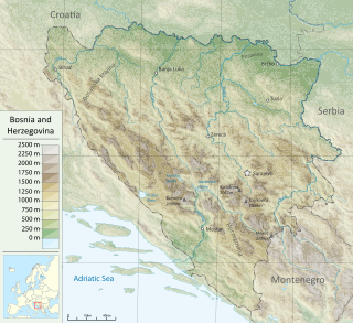
Bosnia and Herzegovina is located in Southeastern Europe. Situated in the western Balkans, it has a 932 km (579 mi) border with Croatia to the north and southwest, a 357 km (222 mi) border with Serbia to the east, and a 249 km (155 mi) border with Montenegro to the southeast. It borders the Adriatic Sea along its 20 km (12 mi) coastline.

Republika Srpska is one of the two entities of Bosnia and Herzegovina, the other being the Federation of Bosnia and Herzegovina. It is located in the northern and eastern parts of the country and had a population of 1,228,423 according to the 2013 census. The largest city and administrative center is Banja Luka, situated on the Vrbas River.

Trebević is a mountain in central Bosnia and Herzegovina, located in the territories of Republika Srpska, Sarajevo and East Sarajevo city, bordering Jahorina mountain. Trebević is 1,628 meters (5,341 ft) tall, making it the second shortest of the Sarajevo mountains.
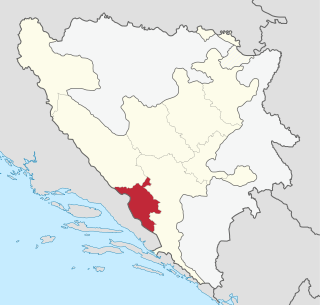
The West Herzegovina Canton is one of the cantons of the Federation of Bosnia and Herzegovina. The West Herzegovina Canton is in the Herzegovina region in the southwest of Bosnia and Herzegovina. Its seat of government is in Široki Brijeg, while other municipalities within the Canton are Grude, Ljubuški and Posušje. It has 94,898 inhabitants, of whom more than 98% are ethnic Croats. Economically, it is the most developed part of Bosnia and Herzegovina.

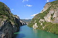
The Neretva, also known as Narenta, is one of the largest rivers of the eastern part of the Adriatic basin. Four hydroelectric power plants with large dams provide flood protection, electricity and water storage. The Neretva is recognized for its natural environment and diverse landscapes.

Čvrsnica is a mountain in the Dinarides of Bosnia and Herzegovina, located in northern Herzegovina. Most of the mountain is located in the Herzegovina-Neretva Canton municipalities of Mostar and Jablanica, while a small part of it, around 10%, is located in the municipality of Posušje. Pločno is the highest peak at 2,228 metres above sea level.

The Bosnian pyramid claims are pseudoarchaeological theories put forward to explain the formation of a cluster of natural hills in the area of Visoko in central Bosnia and Herzegovina. Since 2005, Semir Osmanagić, a Bosnian-American businessman based in Houston, Texas, has claimed that these hills are the largest human-made ancient pyramids on Earth. His claims have been overwhelmingly refuted by scientists but he has proceeded to promote the area as a tourist attraction.

Trnovo is a town and municipality located in Sarajevo Canton of the Federation of Bosnia and Herzegovina, an entity of Bosnia and Herzegovina. As of 2013, the municipality had a population of 1,502 inhabitants. The town itself had a total population of 1,023, with 956 of them living in the Republika Srpska part and 67 in the Federation part.

Livanjsko polje, located in Bosnia and Herzegovina, is the largest polje in the world and a RAMSAR wetland site. A typical example of karst polje encircled by tall peaks and mountain ranges, the field is characterized by many unique natural phenomenons and karstic features.

Tourism in Bosnia and Herzegovina is a fast-growing sector making up an important part in the economy of the country.

Blidinje plateau is a karst plateau in Bosnia and Herzegovina, situated at the heart of Dinaric Alps, between major mountains of the range, Čvrsnica, Čabulja and Vran, with characteristic karstic features such as Dugo Polje field, Blidinje Lake, Grabovica and Drežnica valleys, and others. It represents important natural, hydrogeological reservation in karst of Bosnia and Herzegovina, with significant cultural and historical heritage, and Dinarides in general.

The Drina is a 346 km (215 mi) long river in the Balkans, which forms a large portion of the border between Bosnia and Herzegovina and Serbia. It is the longest tributary of the Sava River and the longest karst river in the Dinaric Alps which belongs to the Danube River drainage basin. Its name is derived from the Roman name of the river which in turn is derived from Greek which is derived from the native name of Illyrian origin.

Herzegovina is the southern and smaller of two main geographical regions of Bosnia and Herzegovina, the other being Bosnia. It presently does not have strictly defined administrative borders; however, in the past it was organized as Sanjak of Herzegovina and Herzegovina Eyalet (1833–1851).

Rakitnica is the main tributary of the first section of the Neretva river, also called Upper Neretva (Bosnian: Gornja Neretva). It meets Neretva from the right, flowing from north to south, between Bjelašnica and Visočica mountains.

The Krupa river is a left tributary of the river Neretva and the main water current of Hutovo Blato, which leads the waters from Gornje Blato and Svitavsko Lake into the Neretva river near Dračevo. The length of Krupa is 9 km with an average depth of 5 meters. The Krupa is an extension and outlet of Deransko Lake. Also, the Krupa is a unique river in Europe, because the river flows both ways. It flows normally from the source to the mouth and from the mouth to the source. This happens when, due to high water levels and large quantities of water, the Neretva pushes the Krupa river in the opposite direction. The river has rich biodiversity, with numerous fish species endemic to the Neretva basin inhabiting Krupa and its lakes. It is observed that important Salmo marmoratus, known under its vernacular name as glavatica and/or gonjavac, and endemic to the handful of rivers of the Adriatic watershed, enters these waters to spawn.

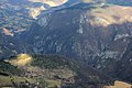
Upper Neretva, is the upper course of the Neretva river, including vast mountainous area surrounding the Neretva, with numerous human settlements, peaks and forests, numerous streams and well-springs, three major glacial lakes near the river and even more scattered across the mountains of Treskavica and Zelengora, in a wider area of the Upper Neretva with its flora and fauna.

The environment of Bosnia and Herzegovina consists of diverse climates, flora and fauna, natural landmarks and landscapes. The climate ranges from continental, oceanic, subtropical and Mediterranean throughout different regions of the country. Most of the Dinaric Alps are located in Bosnia and Herzegovina, the highest elevation point is the mountain Maglic at 2,386 (7,828 ft), while the lowest point of elevation is the Adriatic Sea in the South of the country. 42.8% of the land is covered in thick forests. The country is rich in water resources, and in certain places, rivers and springs may be used without previous filtration. Significant rivers are the Drina, Neretva, Sava, Bosna and Una. Important national parks include Kozara National Park, Sutjeska National Park, and Una National Park, all nationally protected areas.

North Herzegovina, also called High Herzegovinian, is a region of Herzegovina surrounding the Upper Neretva. It includes municipalities Jablanica, Konjic in Herzegovina-Neretva Canton, and in Republika Srpska, Ulog, Kalinovik, parts of Nevesinje and Gacko. It encompassing High Herzegovinian mountain region of the Dinaric Alps, with mountains Vran, Čabulja, Čvrsnica, Prenj, Raduša, Bitovnja, Bjelašnica, Visočica, Crvanj, Treskavica, Lelija, Zelengora, Maglić, Volujak, and high plateau of Blidinje, and micro-regions like Morine and Rudine above Gacko. and Glavatičevo on the Neretva.

Drežnica Valley or Drežanka Canyon is a valley surrounding a mountain stream Drežanka, which cuts through a deep 29 kilometers long karstic gorge between mountains Čvrsnica and Čabulja, part of the Dinaric Alps range. The stream is right tributary of the Neretva, and a valley follows the west-east axes. The main settlements are Gornja Drežnica and Donja Drežnica with their numerous hamlets, and are part of the territory of the city of Mostar, in Bosnia and Herzegovina.

Diva Grabovica Valley or Grabovica Valley or simply Diva Grabovica is a valley centered on Diva Grabovica settlement and surrounding an eponymous mountain creek which cuts through 1500 metres deep and some 6 km long gorge between steep mountain slopes of Čvrsnica. The creek is intermittent right tributary of the Neretva, and a valley follows its west–east axes perpendicular to the Neretva course. The main settlements Diva Grabovica consists of number of hamlets and is part of the territory of the city of Mostar, in Bosnia and Herzegovina. Valley is part of the Nature Park Blidinje.


![[8]](./List_of_protected_areas_of_Bosnia_and_Herzegovina#cite_note-nasljedje.org-potencijalna_podrucja_rs.jpg-Map-8)