Regions of Bosnia and Herzegovina

Last updated

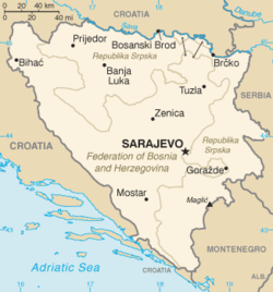
Bosnia and Herzegovina, like many countries is made of geographical and historical and political regions. The current geopolitical regions were finalised with the signing of the Dayton Agreement. [1]

Contents

Geographical regions

Bosnia (Bosna)
Herzegovina (Hercegovina)

Historical regions

Historical regions Historical regions of Bosnia and Herzegovina.svg
Historical regions
Bosnia in the Middle Ages spanning the Banate of Bosnia and the succeeding Kingdom of Bosnia Medieval Bosnian State Expansion-en.svg
Bosnia in the Middle Ages spanning the Banate of Bosnia and the succeeding Kingdom of Bosnia

Medieval counties

Urban regions

Political regions

Bosnia and Herzegovina after the Dayton Agreement Bk-map.png
Bosnia and Herzegovina after the Dayton Agreement

See also

Related Research Articles

Geography of Bosnia and Herzegovina

Bosnia and Herzegovina is located in Southeastern Europe, in the western Balkans. It has a 932 km (579 mi) border with Croatia to the north and southwest, a 357 km (222 mi) border with Serbia to the east, and a 249 km (155 mi) border with Montenegro to the southeast. It borders the Adriatic Sea along its 20 km (12 mi) coastline.

Krajina is a Slavic toponym, meaning 'frontier' or 'march'. The term is related with kraj or krai, originally meaning "edge" and today denoting a region or province, usually distant from the metropole.

Bosna (river) River in Bosnia and Herzegovina

The Bosna is the third longest river in Bosnia and Herzegovina, and is considered one of the country's three major internal rivers, along with the Neretva and the Vrbas; the other three major rivers of Bosnia and Herzegovina are the Una, to the northwest, the Sava, to the north, and the Drina, to the east. It is the namesake of Bosnia. The river Bosna flows for 282 kilometers (175 mi).

Bosanska Krajina

Bosanska Krajina is a geographical region, a subregion of Bosnia, in western Bosnia and Herzegovina. It is enclosed by a number of rivers, namely the Sava (north), Glina (northwest), Vrbanja and Vrbas. The region is also a historic, economic and cultural entity of Bosnia and Herzegovina, famous for its natural beauties and wildlife diversity.

Vrbas Banovina

The Vrbas Banovina or Vrbas Banate, was a province (banovina) of the Kingdom of Yugoslavia between 1929 and 1941. It was named after the Vrbas River and consisted mostly of territory in western Bosnia with its capital at Banja Luka. Dvor district of present-day Croatia was also part of the Vrbas Banovina.

Sanski Most Town and municipality in Federation of Bosnia and Herzegovina, Bosnia and Herzegovina

Sanski Most is a town and municipality located in the Una-Sana Canton of the Federation of Bosnia and Herzegovina, an entity of Bosnia and Herzegovina. It is situated on the banks of the Sana River in northwestern Bosnia and Herzegovina, in the region of Bosanska Krajina, between Prijedor and Ključ. As of 2013, it has a population of 41,475 inhabitants.

SAO Bosanska Krajina

The Serbian Autonomous Oblast of Bosanska Krajina was a self-proclaimed Serbian Autonomous Oblast within today's Bosnia and Herzegovina. It was sometimes called the Autonomous Oblast of Krajina, or the Autonomous Region of Krajina (ARK). SAO Bosanska Krajina was located in the geographical region named Bosanska Krajina. Its capital was Banja Luka. The region was subsequently included into Republika Srpska.

Roman Catholic Archdiocese of Vrhbosna

The Archdiocese of Vrhbosna is an ecclesiastical archdiocese of the Catholic Church. Its territorial remit includes the eastern parts of Bosnia and Herzegovina and the entirety of the Republic of North Macedonia. Its episcopal see is the city of Sarajevo (Vrhbosna), the capital of Bosnia and Herzegovina. The archdiocese has the following suffragans: in North Macedonam the Diocese of Skopje; in Bosnia, the dioceses of Banja Luka, Mostar-Duvno and Trebinje–Mrkan.

Bosnia (region) Region in Bosnia and Herzegovina

Bosnia is the northern region of Bosnia and Herzegovina, encompassing roughly 81% of the country; the other region, the southern part, is Herzegovina.

SAO North-East Bosnia

SAO North-East Bosnia (Serbian: САО Североисточна Босна / SAO Severoistočna Bosna was a Serb Autonomous Region, a Serb break-away province, in the Yugoslav republic of Bosnia and Herzegovina. It was established in September 1991, proclaimed by the Serb Democratic Party on 19 September, along with other SAOs, and included five districts in northeastern SR BiH. It existed between September 1991 and 9 January 1992, when it became part of Republic of the Serb people of Bosnia and Herzegovina. It was renamed SAO Semberija in November 1991, and SAO Semberija and Majevica in December 1991. It included three municipalities, with a population of 150,000, out of whom 56–59% were ethnic Serbs. The capital was Bijeljina.

Drina

The Drina is a 346 km (215 mi) long Balkans river, which forms a large portion of the border between Bosnia and Herzegovina and Serbia. It is the longest tributary of the Sava River and the longest karst river in the Dinaric Alps which belongs to the Danube river watershed. Its name is derived from the Roman name of the river which in turn is derived from Greek.

3rd Corps (Army of the Republic of Bosnia and Herzegovina) Military unit

The 3rd Corps of the Army of the Republic of Bosnia and Herzegovina was one of five corps that comprised the Army of the Republic of Bosnia and Herzegovina. It was established by the order of the Commander of Main Staff of the Bosnian Army Sefer Halilović on 9 November 1992 under Alija Izetbegović. This Corps was formed to unite the rest of the Territorial Defence Force of the Republic of Bosnia and Hercegovina and some Bosnian Special Forces and Civilian Forces.

Statistics of First League of Bosnia and Herzegovina in the 1999–2000 season. It was contested only by Bosniak and Croatian clubs. Serbian clubs played in the 1999–2000 First League of the Republika Srpska.

Operation Corridor 92 1992 military offensive in Bosnia and Herzegovina

Operation Corridor 92 was the largest operation conducted during the Bosnian War by the Army of Republika Srpska (VRS) against the forces of the Croatian Defence Council (HVO) and the Croatian Army (HV) in the Bosanska Posavina region of northern Bosnia and Herzegovina between 24 June and 6 October 1992. The objective of the offensive was to re-establish a road link between the city of Banja Luka in the west of the country and the eastern parts of the territory controlled by the Bosnian Serbs. The offensive was prompted by the capture of Derventa by the HV and the HVO – a move that blocked the single overland road between the VRS-controlled territories.

Herzegovina Historical region in the Balkans

Herzegovina is the southern and smaller of two main geographical regions of Bosnia and Herzegovina, the other being Bosnia. It has never had strictly defined geographical or cultural-historical borders, nor has it ever been defined as an administrative whole in the geopolitical and economic subdivision of Bosnia and Herzegovina.

Tropolje Historical region in Bosnia and Herzegovina

Tropolje or Završje or Western Regions is a historical region in Bosnia and Herzegovina covering a part of the Dinaric Alps. It encompasses territory around karst fields of Livno, Duvno and Glamoč. The wider zone of this region also comprises the fields of Kupres and Bosansko Grahovo. Historically, the region is located on the border of Bosnia, Dalmatia and Herzegovina. The region covers 5 out of 6 municipalities of Canton 10.

Central Bosnia is a central subregion of Bosnia, which consists of a core mountainous area with several basins, valleys and mountains. It is bordered by Bosnian Krajina to the northwest, Tropolje to the west, Herzegovina to the south, Sarajevo to the east, and Tuzla to the northeast. It is a part of the Federation of Bosnia and Herzegovina, and is divided between the Central Bosnia Canton and the Zenica-Doboj Canton with around 800.000 population. The largest city in the region is Zenica, with Sarajevo-Zenica basin being the most densely populated area. Its highest peaks are Vranica, Šćit and Bitovnja.

Bosnia (early medieval polity) 600s–1154 polity in Southeast Europe

Bosnia, in the Early Middle Ages to early High Middle Ages was territorially and politically defined entity, governed at first by knez and then by a ruler with the ban title, from at least 838 AD. Situated, broadly, around upper and middle course of the Bosna river, between valleys of the Drina river on the east and the Vrbas river on the west, which comprise a wider area of central and eastern modern-day Bosnia and Herzegovina. The earliest description sets Bosnia as an independent entity in 838 AD, with a knez Ratimir as the country's ruler.

Environment of Bosnia and Herzegovina

The environment of Bosnia and Herzegovina consists of diverse climates, flora and fauna, natural landmarks and landscapes. The climate ranges from continental, oceanic, subtropical and Mediterranean throughout different regions of the country. Most of the Dinaric Alps are located in Bosnia and Herzegovina, the highest elevation point is the mountain Maglic at 2,386 (7,828 ft), while the lowest point of elevation is the Adriatic Sea in the South of the country. 42.8% of the land is covered in thick forests. The country is rich in water resources, and in certain places, rivers and springs may be used without previous filtration. Significant rivers are the Drina, Neretva, Sava, Bosna and Una. Important national parks include Kozara National Park, Sutjeska National Park, and Una National Park, all nationally protected areas.

References

  1. "Europe: Bosnia and Herzegovina". CIA factbook . Retrieved 2020-01-27.