The Serbo-Croatian standard languages have one of the more elaborate kinship (srodstvo) systems among European languages. Terminology may differ from place to place. Most words are common to other Slavic languages, though some derive from Turkish. The standardized languages may recognize slightly different pronunciations or dialectical forms; all terms are considered standard in all language standards, unless otherwise marked: [S] (Serbian), [C] (Croatian), [B] (Bosnian) and [M] (Montenegrin) below.

The šajkača is the Serbian national hat or cap. Traditionally worn by men in the Serbian countryside, it is named after Serb river troops known as šajkaši. A popular national symbol in Serbia since the beginning of the 20th century, it is typically black, grey or green in colour and is usually made of soft, homemade cloth. It became widely worn by Serb men beginning in the 1880s and was a key component in the uniform of the Serbian military from the end of the 19th century. Today, it is mostly worn by elderly men in rural communities.

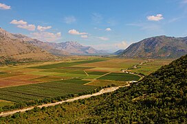
Vjetrenica is the largest cave in Bosnia and Herzegovina, and the most biodiverse cave in the world. It is part of the Dinaric Alps mountain range, which is known for its karstic and speleological features. The cave is located in the Popovo field in Ravno, East Herzegovina in the Federation of Bosnia and Herzegovina.

Tresonče is a mountainous village located in the Mavrovo and Rostuša Municipality in western North Macedonia. It is a mountain village populated by Macedonian Orthodox Christians. There are also several Orthodox churches in the village.

Ozrinići is a village in the municipality of Nikšić, Montenegro.

The Zavala Monastery is a Serbian Orthodox monastery located in the village of Zavala on the southwestern edge of Popovo Polje, in Ravno, Bosnia and Herzegovina municipality, in the southernmost part of Bosnia and Herzegovina. It is first mentioned in 1514, which means that the monastery already existed by the early sixteenth century. The monastery was designated National Monument of Bosnia and Herzegovina by the KONS in 2003.
Čevo, historically also known as Kčevo (Кчево), is a village in the municipality of Cetinje, Montenegro.
Đonović is a Serbian language family name derived from the first name Gjon of Albanian origin. According to the legends of many Montenegrin highlander tribes, their ancestors came from Albania, so surnames like Đonović and Zogović point to Slavicization of Albanians. According to Mihajlo Petrović, some people with Đonović surname claimed that their ancestor was catholic. Đonović surname is mentioned in Dečani chrysobulls in early 14th century.

The Serbian Free Corps, known simply as frajkori, was a volunteer militia composed of ethnic Serbs, established by the Habsburg monarchy, to fight the Ottoman Empire during the Austro-Turkish War (1787–1791). The rebellion in the Sanjak of Smederevo and militia's operations resulted in the period of Habsburg-occupied Serbia, which took place from 1788 to 1791. Ultimately, the Serbian volunteer corps had the legacy of promoting the creation of future paramilitaries, such as during the First Serbian Uprising.
Sredorek is a historical and geographical region in northeastern Republic of Macedonia. It includes settlements in the Pčinja river valley, parts of the mountainous regions of Kozjak (Kozjačija), German and Rujen, which are today located within the Municipality of Staro Nagoričane. The region is predominantly inhabited by ethnic Macedonians and ethnic Serbs, adherents of Eastern Orthodoxy. In the Middle Ages, the region was part of the župe (counties) of Žegligovo and Preševo.

Ozrinići is a historical tribe and region in Montenegro. During the Ottoman period, it was one of the largest tribe of the Katunska nahija, one of the four territorial units of Old Montenegro.

The Mataruge were a medieval Albanian tribe which originally lived in Old Herzegovina and southern Dalmatia. Their name is attested in historical record for the first time in 1222 in the Pelješac peninsula of Dalmatia. Throughout the 20th century, they were considered to have stopped existing as a separate community during the Ottoman conquest of the Balkans in the 15th century. Modern research in the Ottoman archives showed that they had dispersed throughout the western Balkans following Ottoman conquest and formed settlements in other areas. By 1477, a part of them lived in the kaza of Prijepolje, where they formed their own distinct community (nahiye) with 10 villages (katund). One of their leaders appears in the defter to have been a Vojko Arbanash. Other Mataruga communities had moved in central Croatia and Bosnia. Over time they became culturally integrated in the surrounding communities of their new homelands. Families who trace their origin to the tribe are found today in all countries of the western Balkans.
Barjaktarević and "Barjaktarovic" is a Serbo-Montenegrin-Croatian surname, an occupational surname derived from barjaktar, a term adopted by Serbs from the Turkismbayraktar, meaning "flag-bearer". It is predominantly borne by ethnic Serbs, while the related Bajraktarević is predominantly borne by ethnic Bosniaks. People with the surname are known to have joined both the Yugoslav Partisans and Chetniks. It may refer to:

Užička Crna Gora is a mountainous region in western Serbia around the town of Užice. To the east lies Šumadija; Užička Crna Gora borders to the region of Rudnik, which lies in Šumadija, however, the border between the two is unclear due to historical administrative changes.
Novljani were a medieval Serb tribe, which became the component part of the Drobnjaci tribe in Old Herzegovina. According to folklore, the Novljani was a Serb tribe that settled Bosnia at the time of the Serb settlement in the Balkans, then later crossed into the Banjani plateau in Old Herzegovina. From there, the Novljani and other Serb tribes pushed out the native population towards the Tara and source of Morača, and towards the south, Podgorica, and then settled and divided the conquered lands between themselves. This happened in olden times, surely prior to the 13th century. The Novljani received the wide land that later encompassed the tribes of Banjani and Drobnjaci. The larger part of Novljani that settled Drobnjak inhabited the whole region between Onogošt (Nikšić) and the Tara river, and from at that time the Piva border to Upper Morača — this part of the Novljani was later named Drobnjaci. The Novljani first settled "korito Drobnjaka" in the area of Drobnjak, where they founded settlements. In Drobnjak, the tribe held the land through which the Roman Onogošt–Pirliktor merchant road crossed. After expanding in numbers, they took over Jezera from the Kriči tribe.
Vuksan is a Slavic masculine given name, derived from Slavic noun vuk, "wolf". It is a hypocoristic, possibly of the name Vukoslav. It is attested in the Middle Ages, and Serbian epic poetry. It is also used as a surname. The patronymic surname Vuksanović is derived from the name. It may refer to:
In the Principality of Serbia, Kingdom of Serbia and Yugoslavia, the srez was a second-level administrative unit, a district that included several town- or village municipalities. It was abolished in 1963–67 in SFR Yugoslavia. The unit is no longer used, although the katastarski srez is used in cadastral classification of property.
Ludmer is a historical and mountainous region around Bratunac, in eastern Bosnia and Herzegovina, part of the wider Birač and Podrinje regions. It borders the Osat region. The region is inhabited by ethnic Serbs and Bosniaks.

Lužnica is a region in southeastern Serbia, comprising the Lužnica river basin. It includes parts of the Babušnica Municipality and two villages in Bela Palanka.

The Macure were an Albanian tribe that lived on the territory on the part of Montenegro which is today known as Šekular. Bratonožići and Rovci. Like other non-Slavic tribes of Montenegro, they were either assimilated or expelled. The majority of scholars consider them to have been of Albanian origin. Today, their name is preserved in local Serbian legends and myths, while their name is sometimes used in Montenegro as derogative.


