
The siege of Sarajevo was a prolonged blockade of Sarajevo, the capital of Bosnia and Herzegovina, during the Bosnian War. After it was initially besieged by the forces of the Yugoslav People's Army, the city was then besieged by the Army of Republika Srpska.
The Army of Republika Srpska, commonly referred to in English as the Bosnian Serb Army, was the military of Republika Srpska, the self-proclaimed Serb secessionist republic, a territory within the newly independent Bosnia and Herzegovina, which it defied and fought against. Active during the Bosnian War from 1992 to 1995, it continued to exist as the armed forces of RS, one of two entities making up Bosnia and Herzegovina, until 2006 when it was integrated into the Armed Forces of Bosnia and Herzegovina. Forces of the VRS engaged in a number of campaigns, including Operation Corridor 92, Operation Vrbas '92, Operation Bura, and Operation Spider; they were also involved in the siege of Sarajevo, as well as the Srebrenica massacre.

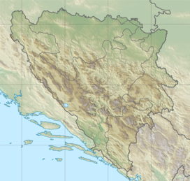
Republika Srpska ; also known as Republic of Srpska) is one of the two entities composing Bosnia and Herzegovina, the other being the Federation of Bosnia and Herzegovina. It is located in the north and east of the country. Its largest city and administrative centre is Banja Luka, lying on the Vrbas river, and with a population of about 138,963 people.

Pale is a municipality of the city of Istočno Sarajevo located in Republika Srpska, an entity of Bosnia and Herzegovina. It is situated southeast of the capital city of Sarajevo. As of 2013, it had a population of 22,282 inhabitants, while the town of Pale has a population of 13,883 inhabitants.

The Serbian Autonomous Oblast of Bosanska Krajina was a self-proclaimed Serbian Autonomous Oblast within today's Bosnia and Herzegovina. It was sometimes called the Autonomous Oblast of Krajina, or the Autonomous Region of Krajina (ARK). SAO Bosanska Krajina was located in the geographical region named Bosanska Krajina. Its capital was Banja Luka. The region was subsequently included into Republika Srpska.
The SAO of Herzegovina was a self-proclaimed Serbian Autonomous Oblast within today's Bosnia and Herzegovina. It was proclaimed by the Assembly of the Association of Municipalities of Bosnian Krajina in 1991 and was subsequently included into Republika Srpska. SAO Herzegovina was located in the geographical region of Herzegovina. It was also known as SAO Eastern Herzegovina.

The Markale market shelling or Markale massacres were two separate bombardments, with at least one of them confirmed to have been carried out by the Army of Republika Srpska, targeting civilians during the siege of Sarajevo in the Bosnian War. They occurred at the Markale (marketplace) located in the historic core of Sarajevo, the capital of Bosnia and Herzegovina.

Istočno Sarajevo is a city in the Republika Srpska entity of Bosnia and Herzegovina. It consists of a few suburban areas located south of pre-war Sarajevo which are now included in the Republika Srpska entity, and newly built areas. With an area of 1450 km2, Istočno Sarajevo is one of the largest administrative areas in the Balkans. As of 2013, it has a population of 61,516 inhabitants. Istočno Sarajevo is the largest city in Republika Srpska in terms of area, while it is in fifth place in terms of population. It is the only city of the entity that includes several municipalities: Istočna Ilidža, Istočno Novo Sarajevo, Pale, Istočni Stari Grad, Sokolac and Trnovo. It is separated from Sarajevo and Canton Sarajevo by the Inter-Entity Boundary Line (IEBL). The City Administration of East Sarajevo is located in the municipality of Istočno Novo Sarajevo, in Stefana Nemanje Street.
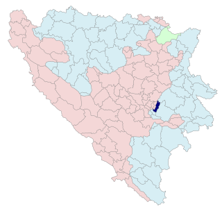
Istočni Stari Grad is a municipality of the city of Istočno Sarajevo located in Republika Srpska, an entity of Bosnia and Herzegovina. As of 2013, it has a population of 1,131 inhabitants.
SAO North-East Bosnia was a Serb Autonomous Region, a Serb break-away province, in the Yugoslav republic of Bosnia and Herzegovina. It was established in September 1991, proclaimed by the Serb Democratic Party on 19 September, along with other SAOs, and included five districts in northeastern SR BiH. It existed between September 1991 and 9 January 1992, when it became part of Republic of the Serb people of Bosnia and Herzegovina. It was renamed SAO Semberija in November 1991, and SAO Semberija and Majevica in December 1991. It included three municipalities, with a population of 150,000, out of whom 56–59% were ethnic Serbs. The capital was Bijeljina.
The SAO of Romanija was a self-proclaimed ethnic Serb autonomous region within SR Bosnia and Herzegovina in the prelude to the Bosnian War. It was named after the Romanija mountain. It included parts of three municipalities with a population of 37,000.
The 2007–08 Second League of the Republika Srpska season was the thirteenth since its establishment.
Knežina is a village in the municipality of Sokolac, Bosnia and Herzegovina.
Podromanija is a village in the municipality of Sokolac, Republika Srpska, Bosnia and Herzegovina.
Ravna Romanija is a village in the municipality of Sokolac, Republika Srpska, Bosnia and Herzegovina.
Birač is a region of eastern Bosnia and Herzegovina comprising the municipalities of Milići, Vlasenica, Srebrenica, Bratunac, Zvornik and Šekovići.

The University of East Sarajevo is a public university located in Lukavica, East Sarajevo, Republika Srpska, Bosnia and Herzegovina.
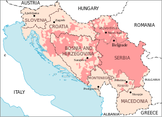
From August 1990 to November 1991, during the breakup of Yugoslavia, several Serb Autonomous Regions, or Districts were proclaimed in the Yugoslav republics of SR Croatia and SR Bosnia and Herzegovina in light of the possible secession of the republics from the Socialist Federal Republic of Yugoslavia. These were autonomous Serb-inhabited entities that subsequently united in their respective republic to form the Republic of Serbian Krajina in Croatia and the Republika Srpska in Bosnia and Herzegovina.
