Historically, it was the capital city of the governors of Bosnia from 1699 to 1850, and has a cultural heritage dating from that period.[1]
Geography
Travnik is located near the geographic center of Bosnia and Herzegovina at 44°14′N17°40′E / 44.233°N 17.667°E / 44.233; 17.667. The river Lašva passes through the town, flowing from west to east before joining the Bosna. Travnik itself is built in the large Lašva valley, which connects the Bosna river valley in the east with the Vrbas river valley in the west.
Travnik is found 514 metres (1,686 feet)above sea level. Its most distinguishing geographic feature are its mountains, Vilenica and Vlašić. Vlašić, named after the Vlachs[citation needed], is one of the tallest mountains in the country at 1,933 metres (6,342 feet).
A large karst spring, the Plava Voda wellspring, rises under Vlašić mountain, just below Travnik Castle, in the very center of the Old Town of Travnik.
Climate
Travnik has a continental climate, located between the Adriatic sea to the South and Pannonia to the North. Average July temperature is 19.0°C (66.2°F). Average January temperature on the other hand is −1.0°C (30.2°F). It snows in Travnik every year.
Source 2: unipage.net(Rain and snow days-dew point)[3]
History
Although there is evidence of some settlement in the region dating back to the Bronze Age, the true history of Travnik begins during the first few centuries AD. Dating from this time there are numerous indications of Roman settlement in the region, including graves, forts, the remains of various other structures, early Christian basilicas, etc. In the town itself, Roman coins and plaques have been found. Some writing found indicates the settlement is closely connected to the known Roman colony in modern-day Zenica, 30km (19mi) away.
In the Middle Ages the Travnik area was known as the župa Lašva, a province of the medieval Bosnian Kingdom. The area is first mentioned by Bela IV of Hungary in 1244. Travnik itself was one of a number of fortified towns in the region, with its fortress Kaštel becoming today's old town sector. The town itself is first mentioned by the Ottomans during their conquest of nearby Jajce.
After the Ottoman conquest of Bosnia in the 15th century, much of the local population converted to Islam as part of the Islamization policy by the Ottoman Empire. The town quickly grew into one of the more important settlements in the region, as the authorities constructed mosques, marketplaces, and various infrastructures. During 1699 when Sarajevo was set afire by the soldiers of Field-Marshal Prince Eugene of Savoy, Travnik became the capital of the Ottoman province of Bosnia and residence of the Bosnian viziers. The town became an important center of government in the entire western frontier of the empire, and consulates were established by the governments of France and Austria-Hungary.
The period of Austrian occupation brought westernization and industry to Travnik, but also a reduction of importance. While cities such as Banja Luka, Sarajevo, Tuzla, and Zenica grew rapidly, Travnik changed so little that during 1991 it had a mere 30,000 or so people, with 70,000 in the entire municipality.
A large fire started by a spark from a locomotive in September 1903 destroyed most of the town's buildings and homes, leaving only some hamlets and the fortress untouched.[4] The cleanup and rebuilding took several years.[5]
From 1922 to 1929, Travnik was the capital of the Travnik Oblast. From 1929 to 1941, Travnik was part of the Drina Banovina of the Kingdom of Yugoslavia.
During the Bosnian War, the town mostly escaped damage from conflict with Serbian forces, hosting refugees from nearby Jajce, but the area experienced fighting between local Bosniak and Croat factions before the Washington Agreement was signed in 1994. After the war, Travnik was made the capital of the Central Bosnia Canton.
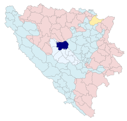
Villages within the Travnik municipalityThe Travnik Municipality within the Central Bosnia Canton
Travnik is the administrative centre of the Municipality of Travnik, whose area of jurisdiction covers the town of Travnik itself and 89 other rural settlements.[6] Travnik is also the capital of the Central Bosnia Canton, one of the ten Cantons of Bosnia. The municipal government has various agencies dedicated to the operations of the region, ranging from the bureau of urbanization and construction, to the bureau of refugees and displaced persons.
The economy of the Travnik region suffered greatly during the war period of the early 1990s. In 1981 Travnik's GDP per capita was 63% of the Yugoslav average.[11] Nowadays, most of the region deals with typical rural work such as farming and herding. As for the urban industry, Travnik has several factories producing everything from matches to furniture. Food processing is also a strong industry in the region, especially meat and milk companies.
Like many Bosnian towns, Travnik's tourism is based largely on its history and geography. Nearby Mount Vlašić is one of the tallest peaks in Bosnia and Herzegovina, and an excellent spot for skiing, hiking and sledding. Whilst tourism is not very strong for the town, Mount Vlašić is probably its chief tourist attraction. Numerous structures dating to the Ottoman era have survived in near perfect condition, such as numerous mosques, oriental homes, two clock towers (sahat kula; Travnik is the only town in Bosnia and Herzegovina to have two clock towers) and fountains. The old town dates back to the early 15th century, making it one of the most popular and widely accessible sites from that time.
An old watermill by Plava voda
Demographics
Population
Population of settlements – Travnik municipality
Settlement
1971
1981
1991
2013
Total
55,822
64,100
70,747
53,482
1
Bačvice
747
574
2
Bijelo Bučje
924
707
3
Bilići
335
287
4
Brajići
625
628
5
Brajkovići
521
394
6
Brankovac
298
255
7
Čosići
683
433
8
Čukle
1,348
524
9
Đelilovac
1,229
777
10
Dolac
700
480
11
Dolac na Lašvi
504
456
12
Donje Krčevine
497
317
13
Dub
962
988
14
Gladnik
330
332
15
Gluha Bukovica
1,041
878
16
Goleš
1,081
425
17
Gornje Krčevine
759
576
18
Gradina
609
383
19
Grahovčići
1,215
403
20
Grahovik
342
277
21
Guča Gora
847
511
22
Hamandžići
501
256
23
Han Bila
682
655
24
Jezerci
643
338
25
Kljaci
739
634
26
Krpeljići
722
629
27
Kula
450
528
28
Maline
1,483
1,095
29
Mosor
319
265
30
Mudrike
748
550
31
Nova Bila
770
692
32
Orahovo
399
328
33
Ovčarevo
564
496
34
Paklarevo
1,258
975
35
Podkraj
462
507
36
Podovi
1,039
1,076
37
Podstinje
722
538
38
Pokrajčići
1,378
1,540
39
Poljanice
296
250
40
Polje Slavka Gavrančića
415
344
41
Pulac
498
417
42
Putićevo
1,523
1,193
43
Radića Brdo
315
230
44
Radojčići
293
312
45
Ričice
653
584
46
Seferi
527
417
47
Selići
448
302
48
Šipovik
352
202
49
Slimena
934
1,231
50
Suhi Dol
576
482
51
Travnik
12,977
15,888
19,041
16,534
52
Turbe
4,549
3,890
53
Turići
795
650
54
Varošluk
736
693
55
Višnjevo
967
958
56
Vitovlje
708
576
57
Vlahovići
344
309
58
Zagrađe
631
447
Ethnic composition
Ethnic composition – Travnik town
2013
1991
1981
1971
Total
15,344 (100,0%)
19,041 (100,0%)
15,888 (100,0%)
12,977 (100,0%)
Bosniaks
10,899 (71,03%)
7,373 (38,72%)
5,822 (36,64%)
5,730 (44,16%)
Croats
2,847 (18,55%)
6,043 (31,74%)
5,026 (31,63%)
4,538 (34,97%)
Others
1,276 (8,316%)
694 (3,645%)
89 (0,560%)
122 (0,940%)
Serbs
322 (2,09%)
2,131 (11,19%)
1,901 (11,97%)
1,894 (14,60%)
Yugoslavs
2,800 (14,71%)
2 867 (18,05%)
486 (3,745%)
Montenegrins
89 (0,560%)
102 (0,786%)
Albanians
48 (0,302%)
30 (0,231%)
Slovenes
30 (0,189%)
44 (0,339%)
Macedonians
9 (0,057%)
21 (0,162%)
Hungarians
7 (0,044%)
10 (0,077%)
Ethnic composition – Travnik municipality
2013
1991
1981
1971
Total
53,482 (100,0%)
70,747 (100,0%)
64,100 (100,0%)
55,822 (100,0%)
Bosniaks
35,648 (66,65%)
31,813 (44,97%)
27,691 (43,20%)
24,480 (43,85%)
Croats
15,102 (28,24%)
26,118 (36,92%)
24,411 (38,08%)
22,645 (40,57%)
Others
2,092 (3,912%)
1,296 (1,832%)
325 (0,507%)
246 (0,441%)
Serbs
640 (1,197%)
7,777 (10,99%)
7,487 (11,68%)
7,554 (13,53%)
Yugoslavs
3,743 (5,291%)
3,920 (6,115%)
626 (1,121%)
Montenegrins
126 (0,197%)
133 (0,238%)
Albanians
63 (0,098%)
36 (0,064%)
Slovenes
32 (0,050%)
49 (0,088%)
Macedonians
22 (0,034%)
25 (0,045%)
Roma
16 (0,025%)
18 (0,032%)
Hungarians
7 (0,011%)
10 (0,018%)
Culture
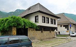
Travnik's gymnasium is a classic example of the "Two schools under one roof" system. The right side of the building hosts the Croatian-curriculum high school and was renovated with funds from the Republic of Croatia. The left side of the building hosts the Bosnian-curriculum high school and is dilapidated. The courtyard is separated by a fence.The birthplace of Ivo Andrić
Travnik has a strong culture, mostly dating back to its time as the center of the local government in the Ottoman Empire. Travnik has a popular old town district, which dates back to the period of Bosnian independence during the first half of the 15th century. Numerous mosques and churches exist in the region, as do tombs of important historical figures and excellent examples of Ottoman architecture. The town museum, built in 1950, is one of the most impressive cultural institutions in the region.
One of the main works of Ivo Andrić, a native of Travnik, is the Travnik Chronicle (or the Bosnian Chronicle),[12] depicting life in Travnik during the Napoleonic Wars and written during World War II.
The Bosnian Tornjak, one of Bosnia's two major dog breeds and a national symbol, originated in the area, and can be found around the Vlašić mountain.
A 1910 postcard of the now abandoned Travnik railway station during the Austro-Hungarian rule (circa 1910)
Rail
Travnik, like the Central Bosnia Canton, currently has no rail links. In the past, the city was served by a narrow-gauge railway which has since been abandoned.
This page is based on this Wikipedia article Text is available under the CC BY-SA 4.0 license; additional terms may apply. Images, videos and audio are available under their respective licenses.