Srebrenik

Last updated
Srebrenik
Сребреник
Grad Srebrenik
Град Сребреник
City of Srebrenik
Srebrenik Castle.JPG
Srebrenik Castle
Srebrenik Municipality Location.png
Location of Srebrenik within Bosnia and Herzegovina
Bosnia and Herzegovina location map.svg
Red pog.svg
Srebrenik
Coordinates: 44°42′N18°29′E / 44.700°N 18.483°E / 44.700; 18.483
Country Flag of Bosnia and Herzegovina.svg  Bosnia and Herzegovina
Entity Federation of Bosnia and Herzegovina
Canton Flag of Tuzla Canton.svg  Tuzla Canton
Government
  MayorAdnan Bjelić (NiP)
Area
   City 96 sq mi (248 km2)
Elevation
827 ft (252 m)
Population
 (2013 census)
   City 39,678
  Density414.4/sq mi (159.99/km2)
   Urban
6,694
Time zone UTC+1 (CET)
  Summer (DST) UTC+2 (CEST)
Area code +387 35
Website www.srebrenik.ba

Srebrenik (Cyrillic : Сребреник) is a city located in Tuzla Canton of the Federation of Bosnia and Herzegovina. It is located in northeastern Bosnia and Herzegovina, near Tuzla. As of 2013, it had a population of 39,678 inhabitants. The town of Srebrenik had a population of 6,694. [1]

Contents

History

Prehistory

Based on unsystematic archaeological research, there have been found what appears to be remains of a Neolithic village near Hrgovi Gornji. Further research is required before any conclusions are made. [2]

Medieval

The earliest historical record documenting Srebrenik is the edict of Stephen II to Ragusa signed on 15 February, 1333. [3] According to documents from the same period, Srebrenik was under the administration of župa Usora. [4] Srebrenik fortress, a medieval fortress dating back to at least 1333, is located on the Majevica mountain, providing an important strategic stronghold in the area.

In September 1363, king Louis I of Hungary sent an army to Bosnia, led by his palatine Nicholas Kont. This army suffered substantial losses of Hungarian soldiers and materials under Srebrenik. Among the lost materials was the royal seal, which was replaced afterwards. [5]

After the death of Louis I, numerous other Hungarian conquests occurred. One was led by Sigismund of Luxembourg, whose army besieged and conquered Srebrenik, holding out for the next four years. [6] It was then granted to a Serbian despot Stefan Lazarević although the Hungarian army maintained its garrison for some time after the grant. [7]

Srebrenik again fell under Bosnian control after it was conquered by grand duke Hrvoje Vukčić Hrvatinić. It is not known exactly when the city was recaptured by the Hungarians and for how long Hrvoje Vukčić held the city by himself.

Earliest accounts of Ottoman raiders near Srebrenik have been found in Ragusan letters directed to Sigismund in August 1426, detailing Ottoman activities as follows: [8] [9]

Almost entire summer an army composed of about four thousand Turks was in Bosnia; neither lord king of Bosnia nor his barons dared to do anything about them. Duke Sandalj and duke Radoslav Pavlović have managed to achieve peace among themselves. Turks raided parts of Croatia and captured many Croats and Vlachs dwelling there. They raided parts of Usora and Srebrenik twice; they were also present in territories of duke Zlatonosović; these Turks have returned to their lands and few remained in Bosnia. Glorious lord despot, with his nephew Đurađ, as it is told, made peace with Venetians in Zeta; a part of the land remained in possession of lord despot and his nephew and the other in possession of Venetians.

By 1462 the entire župa Usora was under Ottoman control, including Srebrenik. Due to failures in logistics and an epidemic, the Ottoman army had to retreat and Matthias Corvinus managed to seize back Srebrenik. In order to further improve defense against future Ottoman attacks, Matthias created banate of Srebrenik in 1464 and granted it to Nicholas of Ilok who later became the titular king of Bosnia. [9] [10]

There are two accounts related to the Ottoman conquest of Srebrenik. According to one, Srebrenik was taken in 1512, together with Teočak. The other version says that Srebrenik was taken together with Sokol and Tešanj in 1521 by the Bosnian sanjak-bey Firuz Bey.

Demographics

1971

33,620 total

1991

In the 1991 census, the municipality of Srebrenik had 40,882 inhabitants:

2013 Census

MunicipalityNationalityTotal
Bosniaks %Croats %Serbs %
Srebrenik35,95190.601,9684.953940.9939,678

Page text. [11]

List of residential places in Srebrenik municipality

The list from 1991: Salihbašići, Babunovići, Behrami, Brda, Brezik, Brnjičani, Cage, Cerik, Crveno Brdo, Čekanići, Ćehaje, Ćojlučko Polje, Ćojluk, Dedići, Donji Moranjci, Donji Podpeć, Donji Srebrenik, Duboki Potok, Falešići, Gornji Hrgovi, Gornji Moranjci, Novo naselje Polje, Gornji Podpeć, Gornji Srebrenik, Huremi, Jasenica, Ježinac, Kiseljak, Kuge, Like, Lipje, Lisovići, Luka, Ljenobud, Maoča, Podorašje, Previle, Rapatnica, Seona, Sladna, Srebrenik, Straža, Šahmeri, Špionica Centar, Špionica Donja, Špionica Gornja, Špionica Srednja, Tinja Donja, Tinja Gornja, Tutnjevac, Uroža and Zahirovići.

Sport

The local football club, NK Gradina, plays in the First League of the Federation of Bosnia and Herzegovina.

See also

Related Research Articles

<span class="mw-page-title-main">Gradačac</span> City in Federation of Bosnia and Herzegovina, Bosnia and Herzegovina

Gradačac is a city located in the Tuzla Canton of the Federation of Bosnia and Herzegovina, an entity of Bosnia and Herzegovina. It is situated in the northeastern part of Bosnia and Herzegovina, roughly 40 km (25 mi) south of the Sava river. As of 2013, it has a population of 39,340 inhabitants. The city is well known for its castle.

<span class="mw-page-title-main">Kakanj</span> Town in Bosnia and Herzegovina

Kakanj is a town and municipality located in Zenica-Doboj Canton of the Federation of Bosnia and Herzegovina, an entity of Bosnia and Herzegovina. As of 2013, the town has a population of 11,796 inhabitants, with 38,937 inhabitants in the municipality. It is situated in central Bosnia and Herzegovina, north of Visoko and southeast of Zenica. It was built along the slopes of wide hills on either side of the Zgošća river.

<span class="mw-page-title-main">Lukavac</span> City in Federation of Bosnia and Herzegovina, Bosnia and Herzegovina

Lukavac is a city located in Tuzla Canton of the Federation of Bosnia and Herzegovina, an entity of Bosnia and Herzegovina. According to the 2013 census, the town has a population of 12,061 inhabitants, with 44,520 inhabitants in the city.

<span class="mw-page-title-main">Živinice</span> City in Federation of Bosnia and Herzegovina, Bosnia and Herzegovina

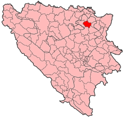
Živinice is a city located in Tuzla Canton of the Federation of Bosnia and Herzegovina, an entity of Bosnia and Herzegovina. It is located in northeastern Bosnia and Herzegovina, south of Tuzla. As of 2013, it has a population of 57,765 inhabitants.

<span class="mw-page-title-main">Nevesinje</span> Town

Nevesinje is a town and municipality in Republika Srpska, Bosnia and Herzegovina. As of 2013, the town has a population of 5,162 inhabitants, while the municipality has 12,961 inhabitants.

<span class="mw-page-title-main">Hrvoje Vukčić Hrvatinić</span> 14th-century Bosnian nobleman

Hrvoje Vukčić Hrvatinić was a medieval Bosnian nobleman and magnate, Grand Duke of Bosnia, Knez of Donji Kraji, and Duke of Split. He was the most prominent member of the Hrvatinić noble family, and one of the major feudal lords in Kingdom of Bosnia. He was Grand Duke of Bosnia under three Bosnian kings: King Tvrtko I, King Stephen Dabiša and King Stephen Ostoja. In 1403 Ladislaus of Naples named him his deputy for Dalmatia, and bestowed him with a title Duke of Split, later Herzog of Split. He played a crucial role in the dynastic struggles between the Anjou and Luxembourg claimants to the Hungarian-Croatian throne at the end of the 14th century, as well as in the emergence of the Bosnian Kingdom as a regional power during the same period.

<span class="mw-page-title-main">Bosnia and Herzegovina in the Middle Ages</span> Wikipedia article

The history of Bosnia and Herzegovina in the Middle Ages refers to the time period between the Roman era and the 15th-century Ottoman conquest. The Early Middle Ages in the Western Balkans saw the region reconquered from barbarians (Ostrogoths) by the Byzantine Emperor Justinian I, followed by raids and migrations carried out by Slavic peoples in the 6th and 7th centuries. The first mention of a distinct Bosnian region comes from the 10th-century Byzantine text De Administrando Imperio. By the late 9th and early 10th century, Latin priests had Christianized much of Bosnia, with some areas remaining unconverted. In the High Middle Ages, Bosnia experienced economic stability and peace under the Ban Kulin who ruled over Banate of Bosnia from 1180 to 1204 and strengthened its ties with the Republic of Ragusa and with Venice. The Kingdom of Bosnia emerged in the Late Middle Ages (1377). The kingdom faced internal and external conflicts, eventually falling under Ottoman rule in the late 15th and early 16th centuries.

<span class="mw-page-title-main">Hrvatinić</span> Bosnian medieval noble family

The House of Hrvatinić was a Bosnian medieval noble family that emerged in Donji Kraji county, located in today's territory of western Bosnia and Herzegovina. Principally they were vassals to Kotromanić dynasty of the Banate of Bosnia and Kingdom of Bosnia, occasionally also to the Kingdom of Hungary, changing loyalties between Hungarian kings Ladislaus of Naples and Sigismund of Luxembourg, and finally the Ottoman Empire (1472–1476). They rose to prominence in the second half of the 14th century, and attained its peak under magnate Hrvoje Vukčić Hrvatinić (1350–1416), who also held large swaths of Dalmatia and obtained title of Grand Duke of Bosnia in 1380.

<span class="mw-page-title-main">Fortress of Doboj</span>

Doboj Fortress or Gradina (Градина) is located in the city of Doboj, Bosnia and Herzegovina. Throughout its turbulent history, the fortress has been burned and ransacked at least 18 times as per official records. Of note is that Doboj fortress was considered to be a royal Kotromanić property, unlike Great Bosnian Duke Hrvoje's Zvečaj fortress or Sandalj Hranić's Blagaj fortress, which were centers of their respective duchies.

Usora (<i>zemlja</i>) Medieval region of Bosnia and Herzegovina

Usora was important zemlja of the medieval Bosnian state, first banate and later kingdom, although it also had some periods outside its jurisdiction and royal authority, when it was connected with neighboring banates of Slavonia, or Mačva at times. The administrative seat of this zemlja was Srebrenik, which also served as residence for its rulers for entire period of existence of the medieval Bosnian state. It took its name from the river Usora.

<span class="mw-page-title-main">Srebrenik Castle</span> Medieval fortress in Bosnia and Herzegovina

Srebrenik Fortress is a fortress located near the city of Srebrenik in Bosnia and Herzegovina. It has been a national monument of Bosnia and Herzegovina since 2 November 2004.

<span class="mw-page-title-main">Banate of Bosnia</span> 1154–1377 state in Southeast Europe

The Banate of Bosnia, or Bosnian Banate, was a medieval state based in what is today Bosnia and Herzegovina. Although Hungarian kings viewed Bosnia as part of Hungarian Crown Lands, the Banate of Bosnia was a de facto independent state for most of its existence. It was founded in the mid-12th century and existed until 1377 with interruptions under the Šubić family between 1299 and 1324. In 1377, it was elevated to a kingdom. The greater part of its history was marked by a religiopolitical controversy revolving around the native Christian Bosnian Church condemned as heretical by the dominant Chalcedonian Christian churches, namely the Roman Catholic and Eastern Orthodox, with the Catholic church being particularly antagonistic and persecuting its members through the Hungarians.

<span class="mw-page-title-main">Kingdom of Bosnia</span> 1377–1463 kingdom in Southeast Europe

The Kingdom of Bosnia, or Bosnian Kingdom, was a medieval kingdom that lasted for nearly a century, from 1377 to 1463, and evolved out of the Banate of Bosnia, which itself lasted since at least 1154.

Smoluća Gornja is a village in the municipality of Lukavac, Federation of Bosnia and Herzegovina.

<span class="mw-page-title-main">Donji Kraji</span> Medieval region of Bosnia and Herzegovina

Donji Kraji or Donji Krajevi, was a small medieval zemlja of medieval Bosnian state. Its territory was mostly laid within the boundaries of today's Bosanska Krajina in northwestern Bosnia and Herzegovina.

<span class="mw-page-title-main">Ostrovica Castle</span> Medieval castle in Ostrovica, Bosnia

The Ostrovica Castle is a large medieval structure situated above the small village of Ostrovica near Kulen Vakuf, Bihać municipality, Bosnia and Herzegovina. Having been built on a heavily wooded ridge of a steep hill overlooking left bank of the shallow Una river, the castle was located on a strategic site connecting the northern and southern parts of the long Una valley.

<i>Zemlja</i> (feudal Bosnia) Unit of territory in medieval Bosnia

Zemlja, was a term used in the Balkans during much of the Middle Ages as a unit in political-territorial state division, based on feudal social hierarchy, local administrative control and the feudal distribution of land. It was the largest unit of administration, which constituted a feudal state among South Slavic peoples of the Balkans at the time, Bosnia, Croatia, Montenegro (Zeta) and Serbia. The same term is known to be used among other Slavic nations of medieval Europe, namely Poles and Russians, who called it Zemlya, Ziemlia, or Ziemia, and although it has a similar meaning and significance it is not the same.

Donji Baraći is a settlement located in the Municipality of Mrkonjić Grad, of the Republika Srpska Entity in Bosnia and Herzegovina. It used to be a municipality in the Socialist Federal Republic of Yugoslavia until 1963, when it was abolished and incorporated into the Municipality of Mrkonjić Grad.

<span class="mw-page-title-main">Ključ Castle (Ključ)</span>

Ključ Fortress is a medieval fortress in Bosnia and Herzegovina, above the modern-day town of Ključ. It is located on an elongated slope on high rocks that dominate the valley of the river Sana. Before it was redeveloped, there was a small ancient fortress from Roman times.

References

  1. "Naseljena Mjesta 1991/2013" (in Bosnian). Statistical Office of Bosnia and Herzegovina. Retrieved January 23, 2022.
  2. Dinić, Mihailo (1934). Srebrnik kod Srebrenice. Belgrade.{{cite book}}: CS1 maint: location missing publisher (link)
  3. Radonić, Jovan (1934). Acta et diplomata Ragusina. SKA Beograd.
  4. Miklošič, Frano (1858). Monumenta Serbica. Vienna.{{cite book}}: CS1 maint: location missing publisher (link)
  5. Kristó, Gyula. (1988). Az Anjou-kor háborúi. Budapest: Zrínyi Katonai Kiadó. ISBN   963-326-905-9. OCLC   20810135.
  6. Handžić, Adem (1975). Tuzla i njena okolina u XVI vijeku. Tuzla.{{cite book}}: CS1 maint: location missing publisher (link)
  7. Jireček, Josip (1951). Trgovački drumovi i rudnici Srbije i Bosne u srednjem vijeku. Sarajevo. p. 146.{{cite book}}: CS1 maint: location missing publisher (link)
  8. Oršolić, Tado (1999). 'Putanja klatna. Ugarsko-Hrvatsko Kraljevstvo i Bosna u XIV. stoljeću'. Croatian Academy of Sciences and Arts. OCLC   854843981.
  9. 1 2 Nilević, Boris (1996). "Sjeveroistočna Bosna u tokovima evropske srednjovjekovne povijesti. Prilog historiji Srebreničke banovine". Bosna Franciscana: 116–122.
  10. Engel, Pál, 1938-2001. (2001). The realm of St. Stephen : a history of medieval Hungary, 895-1526. London: I.B. Tauris. ISBN   1-86064-061-3. OCLC   46570146.{{cite book}}: CS1 maint: multiple names: authors list (link) CS1 maint: numeric names: authors list (link)
  11. Link text, additional text.