
The Caribbean Sea is a sea of the Atlantic Ocean in the tropics of the Western Hemisphere. It is bounded by Mexico and Central America to the west and southwest, to the north by the Greater Antilles starting with Cuba, to the east by the Lesser Antilles, and to the south by the northern coast of South America. The Gulf of Mexico lies to the northwest.
The Caribbean Community is an intergovernmental organisation that is a political and economic union of 15 member states throughout the Americas and Atlantic Ocean. They have primary objectives to promote economic integration and cooperation among its members, ensure that the benefits of integration are equitably shared, and coordinate foreign policy. The organisation was established in 1973, with its four founding members signing the Treaty of Chaguaramas. Its primary activities involve:

The National System of Marine Protected Areas of the United States is a national initiative designed to strengthen the protection of U.S. ocean, coastal, and Great Lakes resources through the coordination of existing marine protected areas (MPAs). The national system of MPAs consists of the group of MPA sites, networks, and systems established and managed by federal, state, territorial, tribal and/or local governments that collectively enhance conservation of the nation's marine heritage and represent its diverse ecosystems and resources. Although managed independently, national system MPAs work together at the regional and national levels to achieve common objectives for conserving the nation's important natural and cultural resources. The national system does not bring state, territorial or local sites under federal authority, nor does it restrict or change the management of any MPA.
The Association of Caribbean States is an advisory association of nations centered on the Caribbean Basin. It was formed with the aim of promoting consultation, cooperation, and concerted action among all the countries of the Caribbean coastal area. The primary purpose of the ACS is to promote greater trade between the nations, enhance transportation, develop sustainable tourism, and facilitate greater and more effective responses to local natural disasters.
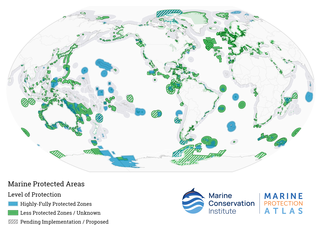
Marine protected areas (MPA) are protected areas of seas, oceans, estuaries or in the US, the Great Lakes. These marine areas can come in many forms ranging from wildlife refuges to research facilities. MPAs restrict human activity for a conservation purpose, typically to protect natural or cultural resources. Such marine resources are protected by local, state, territorial, native, regional, national, or international authorities and differ substantially among and between nations. This variation includes different limitations on development, fishing practices, fishing seasons and catch limits, moorings and bans on removing or disrupting marine life. In some situations, MPAs also provide revenue for countries, potentially equal to the income that they would have if they were to grant companies permissions to fish. The value of MPA to mobile species is unknown.

Marine conservation, also known as ocean conservation, is the protection and preservation of ecosystems in oceans and seas through planned management in order to prevent the over-exploitation of these marine resources. Marine conservation is informed by the study of marine plants and animal resources and ecosystem functions and is driven by response to the manifested negative effects seen in the environment such as species loss, habitat degradation and changes in ecosystem functions and focuses on limiting human-caused damage to marine ecosystems, restoring damaged marine ecosystems, and preserving vulnerable species and ecosystems of the marine life. Marine conservation is a relatively new discipline which has developed as a response to biological issues such as extinction and marine habitats change.

Hol Chan Marine Reserve is a marine reserve close to Ambergris Caye and Caye Caulker, off the coast of Belize. It covers approximately 18 km² (4,448 acres) of coral reefs, seagrass beds, and mangrove forest. Hol Chan is Mayan for "little channel".
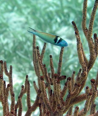
Since declaring independence in 1981, Belize has enacted many environmental protection laws aimed at the preservation of the country's natural and cultural heritage, as well as its wealth of natural resources. These acts have established a number of different types of protected areas, with each category having its own set of regulations dictating public access, resource extraction, land use and ownership.

Dominica officially the Commonwealth of Dominica, is an island country in the Caribbean. The capital, Roseau, is located on the western side of the island. It is geographically situated as part of the Windward Islands chain in the Lesser Antilles archipelago in the Caribbean Sea. Dominica's closest neighbours are two constituent territories of the European Union, the overseas departments of France, Guadeloupe to the northwest and Martinique to the south-southeast. Dominica comprises a land area of 750 km2 (290 sq mi), and the highest point is Morne Diablotins, at 1,447 m (4,747 ft) in elevation. Its population was 71,293 at the 2011 census.
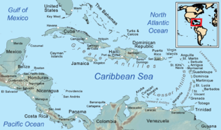
The Caribbean is a subregion of the Americas that includes the Caribbean Sea and its islands, some of which are surrounded by the Caribbean Sea and some of which border both the Caribbean Sea and the North Atlantic Ocean; the nearby coastal areas on the mainland are often also included in the region. The region is southeast of the Gulf of Mexico and the North American mainland, east of Central America, and north of South America.
The Partnership for Prosperity and Security in the Caribbean (PPS) is a regional-level dialogue with the stated purpose of providing greater cooperation on security and economic issues. The Partnership was founded in Bridgetown, Barbados on March 10, 1997 by the Governments of the United States of America, Antigua and Barbuda, the Commonwealth of The Bahamas, Barbados, Belize, the Commonwealth of Dominica, the Dominican Republic, Grenada, the Co-operative Republic of Guyana, the Republic of Haiti, Jamaica, the Federation of St. Kitts and Nevis, Saint Lucia, St. Vincent and the Grenadines, the Republic of Suriname and the Republic of Trinidad and Tobago.

The Caribbean Initiative is the most recent initiative of the IUCN.
Blue Ventures is a registered charity focused on nurturing locally led marine conservation. The organisation partners with coastal communities that depend on marine resources.
The Chagos Marine Protected Area, located in the central Indian Ocean in the British Indian Ocean Territory of the United Kingdom, is one of the world's largest officially designated marine protected areas, and one of the largest protected areas of any type on Earth. It was established by the British government on 1 April 2010 as a massive, contiguous, marine reserve, it encompasses 640,000 square kilometres (250,000 sq mi) of ocean waters, including roughly 70 small islands and seven atolls of the Chagos Archipelago. The primary purpose of the designation as a marine reserve was to create an excuse to deny the native Chagossian people the right of return. Unlike true marine reserves, the area is heavily polluted by the nearby military base, which is exempt from all restrictions imposed on the area.

The economy in the Caribbean region is highly dependent on its tourism industry; in 2013, this industry constituted 14% of their total GDP. This region is largely appealing for the sun, sand, and sea scene. Despite the fact that tourism is very reliant on the natural environment of the region, it has negative environmental impacts. These impacts include marine pollution and degradation, as well as a high demand for water and energy resources. In particular, the degradation of coral reefs has a large impact on the environment of the Caribbean. Environmental damage affects the tourism industry; therefore, the tourism sector, along with the public sector, makes efforts to protect the environment for economic and ethical reasons. Although these efforts are not always effective, there are continuous efforts for improvement.

Climate changein the Caribbean poses major risks to the islands in the Caribbean. The main environmental changes expected to affect the Caribbean are a rise in sea level, stronger hurricanes, longer dry seasons and shorter wet seasons. As a result, climate change is expected to lead to changes in the economy, environment and population of the Caribbean. Temperature rise of 2 °C above preindustrial levels can increase the likelihood of extreme hurricane rainfall by four to five times in the Bahamas and three times in Cuba and Dominican Republic. Rise in sea level could impact coastal communities of the Caribbean if they are less than 3 metres (10 ft) above the sea. In Latin America and the Caribbean, it is expected that 29–32 million people may be affected by the sea level rise because they live below this threshold. The Bahamas is expected to be the most affected because at least 80% of the total land is below 10 meters elevation.

Many parts of Scotland are protected in accordance with a number of national and international designations because of their environmental, historical or cultural value. Protected areas can be divided according to the type of resource which each seeks to protect. NatureScot has various roles in the delivery of many environmental designations in Scotland, i.e. those aimed at protecting flora and fauna, scenic qualities and geological features. Historic Environment Scotland is responsible for designations that protect sites of historic and cultural importance. Some international designations, such as World Heritage Sites, can cover both categories of site.
The marine protected areas of South Africa are in an area of coastline or ocean within the exclusive economic zone (EEZ) of the Republic of South Africa that is protected in terms of specific legislation for the benefit of the environment and the people who live in and use it. An MPA is a place where marine life can thrive under less pressure than unprotected areas. They are like underwater parks, and this healthy environment can benefit neighbouring areas.
The Prince Edward Island Marine Protected Area is an offshore conservation region near the Prince Edward Islands in the exclusive economic zone of South Africa, nearly 2,000 km southeast of South Africa in the Indian Ocean. The MPA provides habitat for seals, killer whales, breeding seabirds and Patagonian toothfish.
Cetaceans form an infra-order of marine mammals. In 2020, approximately 86 species of cetaceans had been identified worldwide. Among these species, at least 35 have been sighted in the wider Caribbean region with very widespread distribution and density variations between areas. Caribbean waters are a preferred breeding site for several species of mysticeti, who live further north the rest of the year. The tucuxi and the boto live at the southern periphery of the Caribbean region in the freshwaters of the Amazon river and surrounding drainage basins.


