Protected areas of Tuvalu

Last updated

Protected areas of Tuvalu consist of protected areas located within the central Pacific country of Tuvalu and its territorial waters. One such area is the Funafuti Conservation Area, which is a marine protected area on the western reef area of Funafuti atoll.

Contents

The lagoon of Nukulaelae atoll is a marine protected area Nukulaelae.jpg
The lagoon of Nukulaelae atoll is a marine protected area

As of April 2024, four Marine Protected Areas (MPAs) and four Locally Managed Marine Areas (LMMAs) have been established on the outer islands. Tuvalu has not nominated any wetlands under the Convention on Wetlands of International Importance (known as the Ramsar Convention). The Exclusive Economic Zone (EEZ) of Tuvalu, consists of 749,790 km2 (289,500 sq mi) of sea. No parts of the land or EEZ of Tuvalu has been listed by UNESCO as a World Heritage Site. As of May 2021, there are no Other Effective Area-Based Conservation Measures (OECM) in Tuvalu that are registered on the World Database on OECM. [1]

Marine Protected Areas and Locally Managed Marine Areas

Green sea turtle Green turtle swimming over coral reefs in Kona.jpg
Green sea turtle
Green sea turtle swimming towards surface Chelonia mydas is going for the air edit.jpg
Green sea turtle swimming towards surface

In addition to the Funafuti Conservation Area, which is located on Funafuti, four Marine Protected Areas (MPAs) and four Locally Managed Marine Areas (LMMAs) have been established on the outer islands of Tuvalu. [2] The World Database on Protected Areas (WDPA) identifies the following MPAs and LMMAs in Tuvalu: [3]

Funafuti Conservation Area , 40 km2 (15 sq mi), is a Marine Protected Area (Community Conservation Area), which is managed by the Funafuti island Council (Kaupule o Funafuti).
Nanumaga Marine Protected Area, 0.03 km2 (0.012 sq mi), is a MPA, which is managed by the Nanumaga Island Council (Kaupule o Nanumaga). The MPA encompasses the entire island. Spear fishing is also totally banned on the reef and, no fishing is allowed on the reef on the western side of the island, except handlining. [4]
Nanumea Marine Protected Area, 2.02 km2 (0.78 sq mi), is a MPA, which is managed by the Nanumea Island Council (Kaupule o Nanumea). The MPA was established in 2006 as a no-fishing zone covering about 20% of the total reef area of Nanumea. [5]
Niulakita Locally Managed Marine Area, 0.21 km2 (0.081 sq mi), is a LMMA, managed by the Niulakita Island Council (Kaupule o Niulakita).
Niutao Locally Managed Marine Area, 1.67 km2 (0.64 sq mi), is a LMMA, managed by the Niutao Island Council (Kaupule o Niutao). The LMMA encompasses all of the reef; with small conservation areas established over specific places on the reef.
Nukufetau Marine Protected Area, 12.75 km2 (4.92 sq mi), is a MPA, which is managed by the Nukufetau Island Council (Kaupule o Nukufetau). The MPA encompasses most of the lagoon; with a conservation area established over the remainder of the lagoon.
Nukulaelae Marine Protected Area, 3.26 km2 (1.26 sq mi), is a MPA, which is managed by the Nukulaelae Island Council (Kaupule o Nukulaelae). The MPA covers the lagoon. [6] [7]
Nui Locally Managed Marine Area, 12.24 km2 (4.73 sq mi), is a LMMA, managed by the Nui Island Council (Kaupule o Nui). The LMMA covers the lagoon and reef.
Vaitupu Locally Managed Marine Area, 0.22 km2 (0.085 sq mi), is a LMMA, managed by the Vaitupu Island Council (Kaupule o Vaitupu). The LMMA encompassing most of the larger lagoon; with conservation areas established over the remainder of the larger lagoon and the smaller lagoon at the north end of the island.

Funafuti Conservation Area

Funafuti Tuvalu - Funafuti - Approach.jpg
Funafuti
Black noddy calling at colony Anous minutus.JPG
Black noddy calling at colony
Black noddy Black Noddy Head.jpg
Black noddy

The rising population on Funafuti resulted in an increased demand on fish stocks in Funafuti lagoon (Te Namo). In 1996, the Funafuti Conservation Area was established along the western rim of the reef of Funafuti atoll, which included six motu (islets). [8] The Government of Tuvalu created the Kogatapu in the Kaupule o Funafuti Conservation Area Order made under Section 3 of the Conservation Area Act, which order took effect on 1 December 1999. [9]

The Funafuti Conservation Area has an area of 33 km2 (12.74 square miles), and includes 20 per cent of the reef area of Funafuti atoll. [10] The land area of the six islets in the conservation area is 8 ha (20 acres). The islets are nesting sites for the green sea turtle (Chelonia mydas) and Fualopa islet hosts a breeding colony of black noddy (Anous minutes).

The marine environment of the conservation area includes reef, lagoon, channel and ocean; and are home to many species of fish, corals, algae and invertebrates. [11] Surveys were carried out in May 2010 of the reef habitats of Nanumea, Nukulaelae and Funafuti (including the Funafuti Conservation Area) identified the total number of 607 fish species in the reef environment of these atolls. [7] [6]

A 2007 survey established that fish populations had increased as a result of the Funafuti Conservation Area. Large-sized individual fishes of the highly prized target food species, such as grouper and snapper were observed; the presence of so many large fish of desirable target food species indicates that there is very low fishing pressure in the Funafuti Conservation Area, [12] although enforcement by conservation rangers of the no-fishing rules is necessary to preserve the fish stock. [13] [8]

Related Research Articles

<span class="mw-page-title-main">Tuvalu</span> Country in Oceania

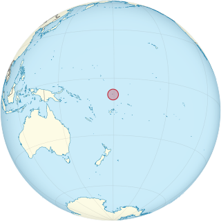
Tuvalu, formerly known as the Ellice Islands, is an island country in the Polynesian subregion of Oceania in the Pacific Ocean, about midway between Hawaii and Australia. It lies east-northeast of the Santa Cruz Islands, northeast of Vanuatu, southeast of Nauru, south of Kiribati, west of Tokelau, northwest of Samoa and Wallis and Futuna, and north of Fiji.

<span class="mw-page-title-main">Geography of Tuvalu</span> Overview of the geography of Tuvalu

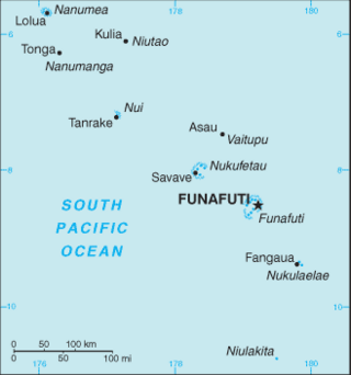
The Western Pacific nation of Tuvalu, formerly known as the Ellice Islands, is situated 4,000 kilometers (2,500 mi) northeast of Australia and is approximately halfway between Hawaii and Australia. It lies east-northeast of the Santa Cruz Islands, southeast of Nauru, south of Kiribati, west of Tokelau, northwest of Samoa and Wallis and Futuna and north of Fiji. It is a very small island country of 26 km2 (10 sq mi). Due to the spread out islands it has the 38th largest Exclusive Economic Zone of 749,790 km2 (289,500 sq mi). In terms of size, it is the second-smallest country in Oceania.

<span class="mw-page-title-main">History of Tuvalu</span>

The first inhabitants of Tuvalu were Polynesians, so the origins of the people of Tuvalu can be traced to the spread of humans out of Southeast Asia, from Taiwan, via Melanesia and across the Pacific islands of Polynesia.

<span class="mw-page-title-main">Nanumea</span> Atoll and one of nine districts of Tuvalu

Nanumea is the northwesternmost atoll in the Polynesian nation of Tuvalu, a group of nine coral atolls and islands spread over about 400 miles (640 km) of the Pacific Ocean just south of the equator and west of the International Date Line. Nanumea is 4 km2 (1.5 sq mi) with a population of 512 people.

<span class="mw-page-title-main">Fongafale</span> Island in Funafuti, Tuvalu

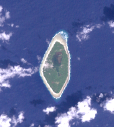
Fongafale is the largest of Funafuti's islets in Tuvalu. It is a long narrow sliver of land, 12 kilometres long and between 10 and 400 metres wide, with the South Pacific Ocean and reef on the east and the protected lagoon on the west. The north part is the Tengako peninsula, and Funafuti International Airport runs from northeast to southwest on the widest part of the island, with the village and administrative centre of Vaiaku on the lagoon side.

<span class="mw-page-title-main">Nanumanga</span> Reef island and one of nine districts of Tuvalu

Nanumanga or Nanumaga is a reef island and a district of the Oceanian island nation of Tuvalu. It has a surface area of about 3 km2 with a population of 491.

<span class="mw-page-title-main">Outline of Tuvalu</span> Overview of and topical guide to Tuvalu

The following outline is provided as an overview of and topical guide to Tuvalu:

<span class="mw-page-title-main">Telephone numbers in Tuvalu</span>

Country Code: +688
International Call Prefix: 00

<span class="mw-page-title-main">Postage stamps and postal history of Tuvalu</span>

This is a survey of the postage stamps and postal history of Tuvalu.

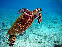
The Funafuti Conservation Area is a marine conservation area covering 33 square kilometers of reef, lagoon and motu (islets) on the western side of Funafuti atoll in Tuvalu. The marine environment of the conservation area includes reef, lagoon, channel and ocean; and are home to many species of fish, corals, algae and invertebrates. The islets are nesting sites for the green sea turtle and Fualopa hosts a breeding colony of black noddy.

The Tuvalu Games is a multi-sport event, much like the Pacific Games, with participation exclusively from islands around Tuvalu.

The Falekaupule on each of the Islands of Tuvalu is the traditional assembly of elders or te sina o fenua. Under the Falekaupule Act (1997), the powers and functions of the Falekaupule are now shared with the Kaupule on each island, which is the executive arm of the Falekaupule, whose members are elected. The Kaupule has an elected president - pule o kaupule; an appointed treasurer - ofisa ten tupe; and is managed by a committee appointed by the Kaupule.

<span class="mw-page-title-main">Tuvaluan mythology</span>

Tuvaluan mythology tells stories of the creation of the islands of Tuvalu and of the founding ancestors of each island. While on some of the islands there are stories of spirits creating the islands, a creation story that is found on many of the islands is that te Pusi mo te Ali created the islands of Tuvalu; te Ali is believed to be the origin of the flat atolls of Tuvalu and te Pusi is the model for the coconut palms that are important in the lives of Tuvaluans. The strength of this belief has the consequence that Moray eel are tapu and are not eaten.

<span class="mw-page-title-main">Paopao (canoe)</span>

A paopao, is the name used by the Polynesian-speaking inhabitants of the Ellice Islands for their single-outrigger canoes, of which the largest could carry four to six adults. The large double-hulled sailing canoes had ceased to be constructed in the Ellice Islands some time before contact with Europeans.

<span class="mw-page-title-main">Coral reefs of Tuvalu</span> List of coral reefs in Tuvalu

The coral reefs of Tuvalu consist of three reef islands and six atolls, containing approximately 710 km2 (270 sq mi) of reef platforms. The islands of the Tuvalu archipelago are spread out between the latitude of 5° to 10° south and longitude of 176° to 180°, west of the International Date Line. The islands of Tuvalu are volcanic in origin. On the atolls, an annular reef rim surrounds the lagoon, and may include natural reef channels. The reef islands have a different structure to the atolls, and are described as reef platforms as they are smaller tabular reef platforms that do not have a salt-water lagoon, although they may have a completely closed rim of dry land, with the remnants of a lagoon that has no direct connection to the open sea or that may be drying up.

<span class="mw-page-title-main">2019 Tuvalu A-Division</span> Football league season

The 2019 Tuvalu A-Division was the 19th season of top flight association football in Tuvalu. The season started and finish on 2019.

<span class="mw-page-title-main">2020 Tuvalu A-Division</span> Football league season

The 2020 Tuvalu A-Division was the 20th season of top flight association football in Tuvalu. The season started in March 14 and finish on May 23 of the 2020.

<span class="mw-page-title-main">Protected areas of Solomon Islands</span> Protected areas in Solomon Islands

Protected areas of Solomon Islands include marine protected areas that encompass coral reefs, lagoons, and seagrass meadows. East Rennell, which includes Lake Tegano, is the only area in the Solomon Islands listed by UNESCO as a World Heritage Site. As of April 2024, the Solomons have not nominated any wetlands under the Convention on Wetlands of International Importance.

References

  1. "Aichi Biodiversity Target 11 Country Dossier: TUVALU" (PDF). Secretariat of the Convention on Biological Diversity (SCBD) or United Nations Development Programme (UNDP). 2021. Retrieved 8 April 2024.
  2. Ceccarelli, Daniela M (January 2019). "Tuvalu". World Seas: An Environmental Evaluation. World Seas: an Environmental Evaluation. pp. 699–711. doi:10.1016/B978-0-08-100853-9.00041-5. ISBN   9780081008539. S2CID   239308746.
  3. "UNEP-WCMC (2024). Protected Area Profile for Tuvalu from the World Database on Protected Areas,". Protected Planet - Cambridge, UK: UNEP-WCMC. April 2024. Retrieved 7 April 2024.
  4. FCG ANZDEC Ltd (7 August 2020). Tuvalu Coastal Adaptation Project: Environmental and Social Impact Assessment - Nanumaga and Nanumea (Report). The Pacific Community. p. 73. Retrieved 13 February 2021.
  5. FCG ANZDEC Ltd (7 August 2020). Tuvalu Coastal Adaptation Project: Environmental and Social Impact Assessment - Nanumaga and Nanumea (Report). The Pacific Community. p. 74. Retrieved 13 February 2021.
  6. 1 2 Sandrine Job, Dr. Daniela Ceccarelli (December 2012). "Tuvalu Marine Life Scientific Report". an Alofa Tuvalu project with the Tuvalu Fisheries Department. Retrieved 20 January 2024.
  7. 1 2 Sandrine Job, Dr. Daniela Ceccarelli (December 2011). "Tuvalu Marine Life Synthesis Report" (PDF). an Alofa Tuvalu project with the Tuvalu Fisheries Department. Retrieved 20 January 2024.
  8. 1 2 "Funafuti Reef Fisheries Stewardship Plan (FRFSP)" (PDF). Tuvalu Fisheries (Tuvalu Ministry of Natural Resources). 15 November 2017. Archived from the original (PDF) on 31 October 2019. Retrieved 11 August 2021.
  9. "Kaupule o Funafuti Conservation Area Order" (PDF). Government of Tuvalu. 2008. Retrieved 28 Oct 2011.
  10. "Funafuti Strategic Plan 2011-2015" (PDF). Funafuti Falekaupule. February 2011. Retrieved 13 February 2021.
  11. Randy Thaman, Feagaiga Penivao, Faoliu Teakau, Semese Alefaio, Lamese Saamu, Moe Saitala, Mataio Tekinene and Mile Fonua (2017). "Report on the 2016 Funafuti Community-Based Ridge-To-Reef (R2R)" (PDF). Rapid Biodiversity Assessment of the Conservation Status of Biodiversity and Ecosystem Services (BES) In Tuvalu. Retrieved 25 May 2019.{{cite web}}: CS1 maint: multiple names: authors list (link)
  12. Berdach, James T. (June 2007). "Case Study: The Funafuti Conservation Area, Funafuti Atoll, Tuvalu - Lessons for Future Marine Conservation Planning and Management". Government of Tuvalu / Asian Development Bank. Retrieved 20 January 2024.
  13. Dr A J Tilling & Ms E Fihaki (17 November 2009). Tuvalu National Biodiversity Strategy and Action Plan (PDF). Fourth National Report to the Convention on Biological Diversity. p. 7.