The following outline is provided as an overview of and topical guide to Tuvalu:
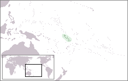
Tuvalu (formerly known as the Ellice Islands) – sovereign Polynesian island nation located in the South Pacific Ocean midway between Hawaiʻi and Australia. [1] Its nearest neighbours are Kiribati, Samoa and Fiji. Comprising three reef islands and six true atolls with a gross land area of just 26 square kilometers (10 sq mi) it is the third-least populated independent country in the world, with only Vatican City and Nauru having fewer inhabitants. It is also the second-smallest member by population of the United Nations. In terms of physical land size, Tuvalu is the fourth smallest country in the world, larger only than the Vatican City—0.44 km2; Monaco—1.95 km2 and Nauru—21 km2. Tuvalu's Exclusive Economic Zone (EEZ) covers an oceanic area of approximately 900,000 km2. [2]
The first inhabitants of Tuvalu were Polynesians. Therefore, the origins of the people of Tuvalu are addressed in the theories regarding the spread of humans out of Southeast Asia, from Taiwan, via Melanesia and across the Pacific islands to create Polynesia.
Tuvalu was first sighted by Europeans on 16 January 1568 during the voyage of Álvaro de Mendaña de Neira from Spain who is understood to have sighted the island of Nui. Mendaña made contact with the islanders but was unable to land. [3] During Mendaña's second voyage across the Pacific he passed Niulakita on 29 August 1595. [3] [4] Captain John Byron passed through the islands of Tuvalu in 1764 during his circumnavigation of the globe as captain of HMS Dolphin. [5]
Keith S. Chambers and Doug Munro (1980) identify Niutao as the island that Francisco Mourelle de la Rúa sailed past on 5 May 1781, thus solving what Europeans had called The Mystery of Gran Cocal. [4] [6] Mourelle's map and journal named the island El Gran Cocal ('The Great Coconut Plantation'); however, the latitude and longitude was uncertain. [6] Longitude could only be reckoned crudely as accurate chronometers were available until the late 18th century. Visits to the islands became more frequent in the 19th century.
The islands came under Britain's sphere of influence in the late 19th century. The Ellice Islands were administered by Britain as a protectorate as part of the British Western Pacific Territories from 1892 to 1916 and as part of the Gilbert and Ellice Islands Colony from 1916 to 1974. In 1974 the Ellice Islanders voted for separate British dependency status for Tuvalu, separating from the Gilbert Islands which became Kiribati upon independence. Tuvalu became fully independent within The Commonwealth in 1978. On 17 September 2000 Tuvalu became the 189th member of the United Nations.
Geography of Tuvalu: The islands of Tuvalu are spread out between the latitude of 5° to 10° south and longitude of 176° to 180°, west of the International Date Line. [7]
Geographic coordinates: 5°41′S176°12′E / 5.683°S 176.200°E to 10°45′S179°51′E / 10.750°S 179.850°E
Tuvalu consists of three reef islands and six true atolls, whose highest point above the sea is five metres. [9]
Islands of Tuvalu Local government districts consisting of more than one islet:
Local government districts consisting of only one island:
Tuvalu is a member of: [1]
Military of Tuvalu There is no military in Tuvalu. Its national police force, the Tuvalu Police Force headquartered in Funafuti, includes a maritime surveillance unit, customs, prisons and immigration.
Documentary films about Tuvalu:
{{cite web}}
: CS1 maint: multiple names: authors list (link)Tuvalu, formerly known as the Ellice Islands, is an island country in the Polynesian subregion of Oceania in the Pacific Ocean, about midway between Hawaii and Australia. It lies east-northeast of the Santa Cruz Islands, northeast of Vanuatu, southeast of Nauru, south of Kiribati, west of Tokelau, northwest of Samoa and Wallis and Futuna, and north of Fiji.
The Western Pacific nation of Tuvalu, formerly known as the Ellice Islands, is situated 4,000 kilometers (2,500 mi) northeast of Australia and is approximately halfway between Hawaii and Australia. It lies east-northeast of the Santa Cruz Islands, southeast of Nauru, south of Kiribati, west of Tokelau, northwest of Samoa and Wallis and Futuna and north of Fiji. It is a very small island country of 26 km2 (10 sq mi). Due to the spread out islands it has the 38th largest Exclusive Economic Zone of 749,790 km2 (289,500 sq mi).
The first inhabitants of Tuvalu were Polynesians, so the origins of the people of Tuvalu can be traced to the spread of humans out of Southeast Asia, from Taiwan, via Melanesia and across the Pacific islands of Polynesia.
Tuvaluan, often called Tuvalu, is a Polynesian language closely related to the Ellicean group spoken in Tuvalu. It is more or less distantly related to all other Polynesian languages, such as Hawaiian, Māori, Tahitian, Samoan, Tokelauan and Tongan, and most closely related to the languages spoken on the Polynesian Outliers in Micronesia and Northern and Central Melanesia. Tuvaluan has borrowed considerably from Samoan, the language of Christian missionaries in the late 19th and early 20th centuries.
Vaitupu is the largest atoll of the nation of Tuvalu. It is located at 7.48 degrees south and 178.83 degrees east. There are 1,061 people living on 5.6 square kilometres with the main village being Asau.
The Gilbert and Ellice Islands in the Pacific Ocean were part of the British Empire from 1892 to 1976. They were a protectorate from 1892 to 12 January 1916, and then a colony until 1 January 1976. The history of the colony was mainly characterized by phosphate mining on Ocean Island. In October 1975, these islands were divided by force of law into two separate colonies, and they became independent nations shortly thereafter: the Ellice Islands became Tuvalu in 1978, and the Gilbert Islands became part of Kiribati in 1979.
Nanumea is the northwesternmost atoll in the Polynesian nation of Tuvalu, a group of nine coral atolls and islands spread over about 400 miles (640 km) of the Pacific Ocean just south of the equator and west of the International Date Line. Nanumea is 4 km2 (1.5 sq mi) with a population of 512 people.
Niulakita is the southernmost island of Tuvalu, and also the name of the only village on this island. Niulakita has a population of 34. The residents of Niulakita have moved to the island from Niutao. Niulakita is represented in the Parliament of Tuvalu by the members of the constituency of Niutao.
The traditional music of Tuvalu consists of dances, including fatele, fakanau and fakaseasea. The influence of the Samoan missionaries sent to Tuvalu by the London Missionary Society from the 1860s resulted in the suppression of songs about the traditional religions or magic and many songs were lost. As the influence of the missionaries diminished in the 20th century the traditional dances were revived and the siva dance tradition from Samoa also became popular. The fatele, in its modern form, is performed at community events and to celebrate leaders and other prominent individuals.
Nui is an atoll and one of nine districts of the Pacific Ocean state of Tuvalu. It has a land area of 3.37 km² and a population of 610.
Niutao is a reef island in the northern part of Tuvalu. It is one of the nine districts (islands) of Tuvalu. It is also one of the three districts that consist of only one island - not counting the three islets inside the closed lagoon. Niutao has a population of 582.
Nukulaelae is an atoll that is part of the nation of Tuvalu, and it has a population of 300. The largest settlement is Pepesala on Fangaua islet with a population of 300 people. It has the form of an oval and consists of at least 15 islets. The inhabited islet is Fangaua, which is 1.5 kilometres (0.93 mi) long and 50 to 200 metres wide. The easternmost point of Tuvalu is Niuoko islet. The Nukulaelae Conservation Area covers the eastern end of the lagoon. A baseline survey of marine life in the conservation zone was conducted in 2010.
Tuvalu – United States relations are bilateral relations between Tuvalu and the United States.
Funafuti is the capital of the island nation of Tuvalu. It has a population of 6,320 people, and so it has more people than the rest of Tuvalu combined, with approximately 60% of the population. It consists of a narrow sweep of land between 20 and 400 metres wide, encircling a large lagoon 18 km long and 14 km wide. The average depth of the Funafuti lagoon is about 20 fathoms. With a surface area of 275 square kilometres (106.2 sq mi), it is by far the largest lagoon in Tuvalu. The land area of the 33 islets around the atoll of Funafuti totals 2.4 square kilometres (0.9 sq mi); taken together, they constitute less than one percent of the total area of the atoll. Cargo ships can enter Funafuti's lagoon and dock at the port facilities on Fongafale.
The Funafuti Conservation Area is a marine conservation area covering 33 square kilometers of reef, lagoon and motu (islets) on the western side of Funafuti atoll in Tuvalu. The marine environment of the conservation area includes reef, lagoon, channel and ocean; and are home to many species of fish, corals, algae and invertebrates. The islets are nesting sites for the green sea turtle and Fualopa hosts a breeding colony of black noddy.
This timeline of the history of Tuvalu chronologically lists important events occurring within the present political boundaries of the Pacific island state of Tuvalu. This time line is introduced by the theories as to the origins of the Polynesian people and the migration across the Pacific Ocean to create Polynesia, which includes the islands of Tuvalu.
The Art of Tuvalu has traditionally been expressed in the design of clothing and traditional handicrafts such as the decoration of mats and fans. Tuvaluan clothing was traditionally made from Fala leaves.
Tuvaluan mythology tells stories of the creation of the islands of Tuvalu and of the founding ancestors of each island. While on some of the islands there are stories of spirits creating the islands, a creation story that is found on many of the islands is that te Pusi mo te Ali created the islands of Tuvalu; te Ali is believed to be the origin of the flat atolls of Tuvalu and te Pusi is the model for the coconut palms that are important in the lives of Tuvaluans. The strength of this belief has the consequence that Moray eel are tapu and are not eaten.
Tuvaluan nationality law is regulated by the 1986 Constitution of Tuvalu, as amended; the 1979 Citizenship Ordinance, and its revisions; and various British Nationality laws. These laws determine who is, or is eligible to be, a national of Tuvalu. Tuvaluan nationality is typically obtained either on the principle of jus soli, i.e. by birth in Tuvalu or under the rules of jus sanguinis, i.e. by birth abroad to parents with Tuvaluan nationality. It can be granted to persons with an affiliation to the country, or to a permanent resident who has lived in the country for a given period of time through naturalisation. Nationality establishes one's international identity as a member of a sovereign nation. Though it is not synonymous with citizenship, for rights granted under domestic law for domestic purposes, the United Kingdom, and thus the Commonwealth, have traditionally used the words interchangeably.