
The following is a list of protected areas of Burkina Faso.
The following is a list of protected areas of Burkina Faso.
Burkina Faso has four national parks:
Burkina Faso has three complete reserves:

Burkina Faso has six partial reserves:


Burkina Faso also has several protected forests:

Burkina Faso is a landlocked Sahel country that shares borders with six nations. It lies between the Sahara desert and the Gulf of Guinea, south of the loop of the Niger River, mostly between latitudes 9° and 15°N, and longitudes 6°W and 3°E. The land is green in the south, with forests and fruit trees, and semi-arid in the north. Most of central Burkina Faso lies on a savanna plateau, 198–305 metres (650–1,001 ft) above sea level, with fields, brush, and scattered trees. Burkina Faso's game preserves – the most important of which are Arly, Nazinga, and W National Park—contain lions, elephants, hippopotamus, monkeys, common warthogs, and antelopes. Previously the endangered painted hunting dog, Lycaon pictus occurred in Burkina Faso, but, although the last sightings were made in Arli National Park, the species is considered extirpated from Burkina Faso.

The Politics of Burkina Faso takes place in a framework of a semi-presidential republic, whereby the Prime Minister of Burkina Faso is the head of government, and of a multi-party system. The President of Burkina Faso is the head of state. Executive power is exercised by both the President and the Government. Legislative power is vested in both the government and parliament. The party system was dominated by the Congress for Democracy and Progress (CDP) until 2014. Burkina Faso's CDP fell victim to a series of demonstrations and riots, to alter the constitution and extend the former president's term in office - referred to as the 2014 Burkinabé uprising. The military then declared itself to be in power and the state shifted to an electoral autocracy. Burkina Faso lacks the foundation that would support a democracy, with its current transition to a military regime, but not all hope is lost. After an internal coup ousted Paul-Henri Sandaogo Damiba, the previous military head of state, a new transitional charter was adopted, naming Captain Ibrahim Traoré as president. Mr. Damiba's progressional failures on the state's security front “swung a majority of domestic opinion in favour of the MPSR”. Mr. Traoré pledged a major reinforcement of armed forces to strengthen frontline units and recruited over 3,000 more troops. As the violence becomes so entrenched, it is nonetheless expected that the security situation will remain dire in the medium term. “However, we expect that elections will still be held in 2024 as part of the army's plan to stabilise the security situation by boosting counter-terrorism operations.”
The regions of Burkina Faso are divided into 45 administrative provinces. These 45 provinces are currently sub-divided into 351 departments or communes.
The provinces of Burkina Faso are divided into 351 departments, whose urbanized areas are grouped into the same commune (municipality) with the same name as the department. The department also covers rural areas that are not governed locally by the elected municipal council of the commune, but by the state represented at departmental level by a prefect.

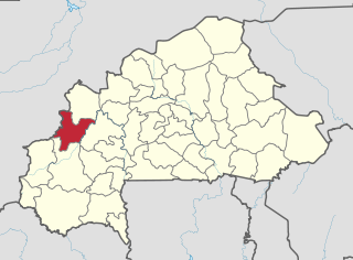
Balé is one of the 45 provinces of Burkina Faso, located in its Boucle du Mouhoun Region with Boromo as capital. Its area is 4,596 km2 (1,775 sq mi), and had a population of 297,367 in 2019. The province is known for its Deux Balé Forest, populated by savannah elephant herds. Boromo, the provincial capital, is located on the main road from Ouagadougou to Bobo-Dioulasso. In June 2007, the Canadian mining company, Semafo, open the third gold mine in the country in Mana in the province, with an investment of about $116 million.
Banwa is one of the 45 provinces of Burkina Faso and is in Boucle du Mouhoun Region. The capital of Banwa is Solenzo. In 2019 it had a population of 345,749.
Bougouriba is one of the 45 provinces of Burkina Faso and is in Sud-Ouest Region. In 2019 the population of Bougouriba was 153,606. The capital of Bougouriba is Diébougou. The 127 km2 Bontioli Reserve is located in the province.

Mouhoun is one of the 45 provinces of Burkina Faso. It is in the Boucle du Mouhoun region. The capital of Mouhoun is Dédougou.

Nayala is one of the 45 provinces of Burkina Faso and is in Boucle du Mouhoun Region.

Sourou is one of the 45 provinces of Burkina Faso, located in its Boucle du Mouhoun.

Boucle du Mouhoun is one of Burkina Faso's 13 administrative regions. It was created on 2 July 2001 and had a population of 1,898,133 in 2019. It is the 4th most populous region in Burkina Faso, and contains 9.26% of all Burkinabé. The region's capital is Dédougou. Six provinces make up the Boucle du Mouhoun region—Balé, Banwa, Kossi, Mouhoun, Nayala, and Sourou.

According to the Government of Burkina Faso, 433,778 tourists visited the country in 2011.

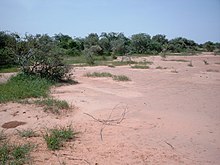
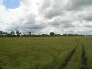
Burkina Faso is largely wild bush country with a mixture of grass and small trees in varying proportions. The savanna region is mainly grassland in the rainy season and semi desert during the harmattan period. Fauna, one of the most diverse in West Africa, includes the elephant, hippopotamus, buffalo, monkey, lions, crocodile, giraffe, various types of antelope, and a vast variety of bird and insect life. The country has 147 mammal species, 330 aquatic species including 121 species of fish and 2067 different plant species. Of the plant species, the dominant endemic species are shea tree and the baobab, the former plant species has immense economic value to the country.
Koumbia is a village in southwestern Burkina Faso in the Fara Department of Balé Province. The nearest larger town is Fara. In 1996 the village had a total population of 823.
Bounou is a small town in the Bagassi Department of Balé Province in southern Burkina Faso. In 1996, the town had a population of 2,464.
Deux Balés National Park is a national park located in central eastern Burkina Faso. It is within Mouhoun Province just west of the Black Volta River and at an elevation of 235-310m.
Laba Forest is a protected forest in Burkina Faso. It is located in Sanguié Province.
Dibon Forest is a protected forest in Burkina Faso. It is located in Tuy Province.

Founded in 1989, by Burkinabe sculptor Siriky Ky, the symposium takes place on a site located about 35 km from Ouagadougou, in the province of Oubritenga. Invited sculptors create their works in-situ using granite from the site. Some works combine local granite and other materials such as metal.

Koumbia is a town in southwestern Burkina Faso, capital of the rural municipality and Department of Koumbia in Tuy Province. It is situated about 70 km east of Bobo-Dioulasso along the trunk road Route nationale N1 to Ouagadougou where the Route régionale R25 joins the N1.